Sunday, December 14, 2014

Templeton Trail to Cathedral Rock


Jim Manning planned and led this hike to Cathedral Rock on 25 October 2014. It was planned as a short hike to be followed by a party at Jim's house in honor of several hikers who had recently or soon would be celebrating their seventieth birthday. These were Lila, Daisy, Miriam and Jim himself.

From Cottonwood, we drove to the Village of Oak Creek, turned west on Verde Valley School Road and continued for about 5.2 miles before parking in the Baldwin Trail parking area. The lot is on the left side of the road but the trailhead is on the right, so one parks and then crosses the road to start hiking. Of course crossing a rural dirt road is not usually very difficult or hazardous.

Before leaving the parking area we posed for a group photograph. We were thirteen strong today; however, two hikers choose to remain unidentified. The remaining eleven are shown below.

Left to right: Donna Goodman, Jim Manning, Miriam Sterling, Anita Jackson, Daisy Williams, Frank Lombardo, Betty Wolters, Dolly Yapp, Samantha Moor, the author and Gary Jacobson – photograph by Name withheld

We crossed the road and found one of those old, rusted, but seemingly indestructible metal signs (right) marking the Baldwin Trailhead. To reach the Templeton Trailhead we would need to hike about 0.7 miles along Baldwin.
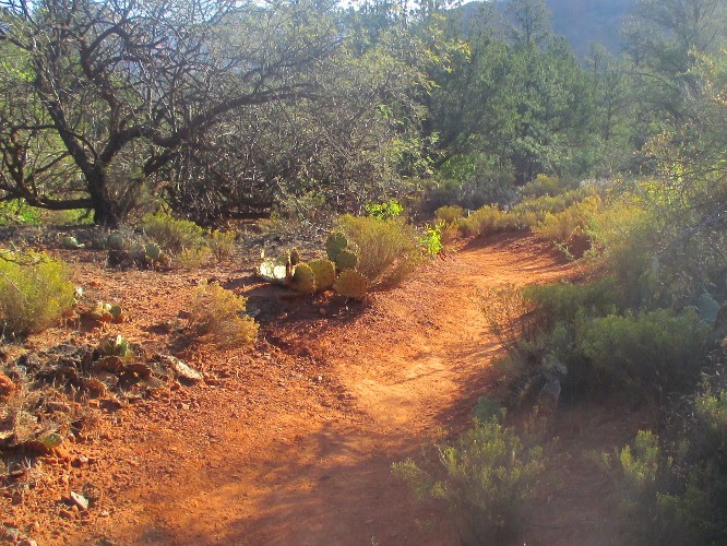
Baldwin was a well-marked and well-used trail (left). I would not, however, wish to hike it during wet weather. The surface was worn into that fine, powdery dust that one sees in the Red Rock area and which, when wet, sticks to boots like glue.

We descended to the Oak Creek flood plain and found ourselves in a small, lovely meadow between the creek and a red rock cliff.

Small meadow in Oak Creek floodplain


Today the trail was dry, the hiking easy and we were shortly at the clearly-marked start of Templeton Trail (right). At this point Baldwin Trail heads up a wash that separates a separate 4400 foot butte from Cathedral Rock proper, circles around that butte, and returns to the starting point.

Templeton Trail, on the other hand, continued at an angle on toward Oak Creek. Just past the Templeton/Baldwin Trail junction a spider had apparently spent the night weaving an intricate web (left) between some twigs and two strands of barbed wire. The web fairly glistened in the morning sun and I could imagine the proprietor sitting somewhere in the maze congratulating himself on his excellent handiwork. Or do spiders appreciate beauty; perhaps they just take a utilitarian view of everything.

We next came to an area where the canyon walls closed in and we were squeezed between the cliff and the creek (right). The trail now turned to the right and slanted up the cliff wall at a fairly decent slope. However, it was still well-defined and the footing was good, and there were a number of switchbacks to alleviate the climbing. All in all, it was not a very difficult climb.

The two photographs below show the start of the climb and the first of the five switchbacks that would take us to the shelf running along the foot of Cathedral Rock that was our goal.

Start of climb from Oak Creek
  First of five switchbacks
After rounding the last switchback, the trail followed a shelf (or ledge) around the northeast side of Cathedral Rock. Looking ahead to the southeast we had a clear view of Courthouse Butte outlined against the morning sky in the distance.


Courthouse Butte outlined against the morning sky

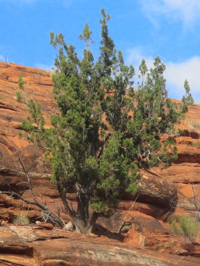
About 0.2 miles after reaching the ledge we stopped for a snack where the trail made a sharp bend as it dipped into and back out of a deep indentation eroded into the wall of the mountain. Just above us a small juniper (left) clung tenaciously to the cliff face, defying both wind and drought.

The trail had pretty much been ours thus far. However, soon after continuing from our snack break, we were joined by several other hikers and also by a large number of bikers. I wondered “where did they all so suddenly come from,” a question that was soon answered when we came first to the Cathedral Trail crossing and then, a short distance, away a junction with the Easybreezy Trail. Even farther ahead is the HT Trail crossing. Hikers and bikers from all of these feeder trails use Templeton Trail to transit from one trail to another.

Although we spent a great deal of time stepping off the trail to let bikers pass and avoid bumping into other hikers, the views were well worth it.

Panoramic view of Cathedral Rock

After seeing this much of Templeton Trail, I am determined to do the rest of it in the future, perhaps even including a climb on up Cathedral Rock Trail.

Jim had done an excellent job by selecting a hike that would both be enjoyable and give us a good workout while still allowing us to finish in time to enjoy the birthday party for the bumper crop of 70 year old hikers.

According to my GPS, the round trip hike was 5 miles, the highest elevation was 4173 feet and the total ascent was 702 feet.

Our track is shown in red on the included map (see next page).


Saturday, December 13, 2014

Slate Mountain Trail


A hike on Slate Mountain Trail had been on my list of things to do for more than two years when we finally did it on 18 October 2014. We drove north on I-17 to Flagstaff, continued straight on Milton when the freeway ended, passed under the railroad overpass, took the sharp right turn and then turned left onto US Hwy 180 (Humphreys Street). We drove on US 180 for 26.7 miles, passing the turnoff to Snowbowl along the way, turned left onto Forest Road 191 and drove another 1.9 miles before parking at the Slate Mountain Trailhead.

On arrival we hoisted our packs and then posed for a group photograph. On a whim we decided to accentuate height differences by having the two short hikers stand in a gully while everyone else towered over them.
Left to right: Karl Sink, David Beach, Anita Jackson, Daisy Williams,  the
 author, Betty Wolters and Lila Wright – photograph by Name Withheld
We then paused to read a Forest Service sign that provides a good description of the trail.
Trail description from National Forest Sign

I later read that Slate Mountain, formed between 1.5 and 1.9 million years ago, is a “laccolith, a solid igneous intrusion between sedimentary strata.” The mountain might well have been called Rhyolite Mountain as it is primarily composed of a solid mass of rhyolite that extends for some 5000 feet below the surface. Sedimentary layers were pushed aside by the intrusion and the name Slate Mountain is said to come from one of these sedimentary layers.1

Slate Mountain is younger than Bill Williams Mountain, Sitgreaves Mountain and Kendrick Peak, but older than Mount Elden and Humphreys Peak with its surrounding summits.2

The trail follows the course of an old road that once led to a lookout tower located atop the mountain.3

The old roadbed makes an excellent trail, rising gently up the slope of the mountain.

We started in a forested area that had been burned over several years ago, the SummitPost trail post quoted above suggested the burn occurred in 2000 and that looks about right from what we saw. As always, the burn area (right) was an opportunity for new growth of different species that thrive in the absence of mature trees.

As an example, I saw several instances of what I think was blue grama grass rings (left). This is a phenomenon that commonly occurs “in resource-limited arid and semi-arid environments” and is thought to occur due to “negative feedback between sediment deposition and vegetation growth” inside clumps of grass. This growth pattern is, however, not limited to blue grama grass and I am no grass expert, so this might well be another species.4

Notable also was the abundance of cliffrose in the burn area. It had appeared at first as isolated shrubs (right).

But the cliffrose, with its subtle, offwhite blossoms, became ever more abundant as we climbed higher in the burned area and we were soon traveling through a veritable cliffrose forest.


Slate Mountain Trail with cliffrose shrubs on both sides

We saw several isolated flowers along the way. One that especially struck my fancy was a purple locoweed (left) on which a colorful butterfly had alighted for a refreshing sip of nectar. I made an attempt to identify the butterfly and finally decided that would take more effort than I was prepared to devote to the subject. I did find several that looked very similar, but often the different species seemed to be differentiated by as little as a single spot or a bar connecting two spots. I decided to leave identification to the entomologists.

We had been traveling in a generally northeast direction, but just after leaving the burn area the trail took a sharp turn to the west to climb the mountain slope. We stopped at a viewpoint just near the turn to look out to the south. We had a grand view of Kendrick Peak, slightly west of directly south, and the surrounding prairie spread out below us.

                                         Kendrick Peak, slight left of center, and the surrounding prairie

Just below the top of the mountain we found an Oregon grape plant (right) growing on the road bank. Along with a number of other plants seen along the way, it had been identified and a sign had been posted by the Forest Service sometime in the past. Sadly most of the identifying signs have now gone missing.

At the very top of the mountain the slanting trees (left) bear mute testimony to the strong prevailing winds that sweep the area.

The old road ends just below the top in an area that shows signs of having been quarried. Perhaps someone in the past took advantage of the lookout tower road to haul quarried stone to market. Or perhaps the lookout tower was preceded by the quarry. The trail continues on making a sharp spiral through the leaning trees shown above to arrive in an open area, presumably the site of the old lookout tower. However, we saw no signs that anything had ever been erected there.

We stopped to eat lunch and enjoy the scenery spread out around us in all directions. From our vantage point it was easy to understand why this spot would have been chosen for a lookout tower. The photograph below shows the far-away San Francisco Peaks on the left and Kendrick Peak just right of center.

                                           San Francisco Peaks at left, Kendrick Peak at right of center

After lunch we headed back down the trail, stopping often along the way to admire trees, plants and flowers. On the way up I had noted that the last cliffrose was at an elevation of around 6700 feet and the first Douglas fir tree appeared at about 8000 feet. Having photographed several cliffroses already, I made a special point of photographing a fir (right) on the way back.  

Between the fir tree and the highest elevation cliffrose we found a fremont holly grape shrub (left) growing alongside the trail, the only one I saw today.

Not far from the fremont holly grape we found the most colorful flower we had seen all day. It was a skyrocket (right) standing all alone in splendid isolation, barely far enough off the trail to escape being trampled.

Two additional flowers, an Indian paintbrush and a groundsel, were located in the burn area and I don't know how they had escaped my attention on the way up the trail.
Indian Paintbrush


Groundsel
 

According to my GPS, the round trip hike was 4.8 miles, the highest elevation was 8229 feet and the ascent was 1111 feet.

The hike route is shown in red on the included map (next page).


1http://www.summitpost.org/slate-mountain/152873
2Ibid
3http://www.summitpost.org/slate-mountain-mountain-trail-128/161672

4http://people.virginia.edu/~pd6v/Publications_files/2008-Ravi_oecologia%20Grass%20Rings.pdf

Wednesday, December 10, 2014

Crook Trail - Twentynine Mile Tank to County Line


Seven Skyliners hiked the section of Crook Trail from Twentynine Mile Tank (actually from Forest Road 144) to the Yavapai/Coconino County line on 11 October 2014. We drove from Cottonwood to the county line on Hwy 260 and dropped one car. We then proceeded to mile marker 249, turned north on Forest Road 144 and drove another 0.5 miles to the point where Crook Trail crosses FR 144. A family had set up camp at our chosen parking area, but there was plenty of room for everyone, so we parked, disembarked, donned our hiking gear and gathered for a group photograph before heading down the trail.

    Left to right: Betty Wolters, Karl Sink, Daisy Williams, the author, Lila
Wright and Kwi Johnson – photograph by Name Withheld
We started our hike by following an old, still traveled road through the ponderosa pine forest. Other than one passing 4-wheeler, a couple of squirrel hunters and a tarantula scurrying along the trail on some unknown mission, we had the trail to ourselves.

We chatted with the hunters for a few minutes and learned that they had nothing as yet to show for their efforts, but were still convinced that they would earn their dinner before the day was done. Of course, optimism is the first requirement for being a hunter. As for the tarantula, (right) we also stopped to visit with him; however, he seemed disinclined to reveal the purpose of his wild scurrying about, so we were soon on our way again.


We were at an elevation of just over 7000 feet on the Mogollon Rim and we knew that we would eventually leave the ponderosa forest behind in favor of junipers, pinons and other low-growing trees as we descended from the rim. As it happened, we passed in and out of discrete ponderosa groves several times before finally leaving them behind entirely. By the time we first emerged into a more open terrain we had left the currently used dirt road behind, but we were guided on our way by one of the ever-present chevrons posted on a tree. In other places no markers were needed as the old wagon road was easily discerned.
Chevron on tree at left
Old Crook wagon road still discernible

Hiking through this more open terrain was a bit more difficult as much of the old road bed had eroded away leaving rocks of various sizes behind. But we took our time, walked carefully and stopped often to enjoy the sights. One particular noteworthy object (or possibly objects) is shown in the picture below. I still don't know whether this is a single alligator juniper fighting to become two or two of them making love.

Alligator juniper(s) – breaking up or making out?
We had wondered just where Twentynine mile Tank was located and that question was finally answered. It is located approximately 2.2 miles from FR 144. Twentynine Mile Butte, meanwhile, is located about half way between the tank and FR 144.

This section of Crook Trail is much easier to hike than is the section between Clear Creak and the county line. We were hiking about an 8.9 miles section today and would descend only around 900 feet. I had deliberately chosen to hike down the trail rather than up, thinking it would be a little easier. However, that precaution was hardly necessary as it would also have been a relatively easy uphill hike.

When we came to what would be our last ponderosa grove we found the larger pines to be more widely scattered and interspersed with smaller trees, mostly small ponderosa but also some oaks.

Large ponderosas widely dispersed with smaller trees underneath
We didn't see a lot of colorful foliage on this hike. It was a little early for most of the deciduous trees, primarily oaks, that were scattered about. However, we did find one particularly beautiful spot (left) where a Hwy 260 underpass was framed by the striking red fall foliage of sumacs.

Although we noted relatively few flowers on this hike, those we did find were especially attractive. Some of these are shown below.

Mountain aster?
 Indian paintbrush
The contrasting red and yellow flowers (below right) are Indian paintbrush and, according to Daisy Williams, yellow composites or perhaps goldenrod. According to one source yellow wildflowers are often just referred to as “damned yellow composites” because there are so many different varieties and identification is so frustrating.

I have referred to being guided along the trail by chevrons and by the remaining trace of the old wagon road. Often some of the more striking trees were selected to display the chevrons. For example, the ancient alligator juniper shown here (left).

Additionally, other markers such as wire-bound cairns, the remains of destroyed cairns and even an occasional official National Recreation Trail sign all provide guidance. Coupled with the use of a downloaded GPS track, these markers pretty well ensured that we would not go far wrong on the Crook Trail.
A neat wire-bound cairn
            The remains of a cairn
In this photograph (below right), of an official National Recreation Trail marker, the colorful letters in the middle of the sign once said USA. The S, the top letter, is almost completely gone now, but if you look carefully you can still make out the U and the A, the bottom two letters. Note also that the chevron shown here is copper-colored. It is just one of the regular aluminum chevrons, as shown elsewhere in this report, painted with copper paint. I have no idea why anyone would go to the trouble to apply paint, but we have observed several of them on this and previous hikes.

At various points as we made our descent we had excellent views all the way to the distant San Francisco Peaks (left) beyond Flagstaff.

The below photograph was taken looking south. We were hiking along very close to Hwy 260 and the area between us and the highway was dotted with Indian paintbrush, showing here as a faint reddish-orange tint in the grass on the other side of the fence. This scene was stitched together from three separate photographs.

Panoramic view looking south from Crook Trail
The hike was 8.9 miles, the highest elevation was 7113 feet, the total ascent was 531 feet and the total descent was 1424 feet. The GPS track is shown in red on the attached map (next page).


Tuesday, December 9, 2014

A Hike in the Pine Grove Quiet Area


This 4 October 2014 hike would be our first of the 2014/2015 season and we had decided to start the season with a hike in the Pine Grove Quiet Area. From I-17 at Flagstaff we turned onto Lake Mary Road and continued for about 17 miles to the Pine Grove Campground turnoff. We turned right as though going to the campground, crossed Walnut Creek and then, almost immediately, turned left into a parking area.

We were now in the quiet area where no motorized traffic is allowed between 15 August and 1 January. Donning our packs we headed south, finding ourselves following a section of the Arizona Trail.

Strangely, no “You Are Here” marker appeared on the map (right). But, for those who might be interested, we were just below the loop in the trail at Flagstaff. One branch runs directly through the city, the other loops to the east and bypasses it.

Almost immediately we found ourselves following along the course of a raised ridge of earth, a man-made berm or dike, running along the ridge. One of our hikers had previously hiked in the area with a Forest Service-sponsored group and was told by the group leader that it was the remains of an old railroad track intended to be part of the proposed Arizona Mineral Belt Railroad (AMBRR), which was intended to connect Globe and Flagstaff. The promoters, partially backed by the Atlantic and Pacific (A&P) Railroad, began working on a tunnel at the Mogollon Rim in 1883. However, the A&P withdrew its support the very next year. Work on the tunnel was stopped and the promoters moved to Flagstaff and started building south. By 1887 AMBRR trains were running between Flagstaff and a station about ten miles south of Mormon Lake.1

The raised ridge we were following was barely wide enough on top to hold even a narrow-gauge railroad. It was suggested that it might once have been wider but had eroded away since the 1880s, when it supposedly was erected. However, the sides appeared much too smooth for that to have been the case. Additionally, there was no evidence that the builders had used stone or gravel to form a solid foundation for a roadbed. This would surely have been done if it really were part of the AMBRR. It is possible that it was a spur railroad built to haul logs from Anderson Mesa just across Walnut Canyon. That sort of route would only have needed to last until the timber was harvested and could have been built to less exacting standards. A section of the raised formation is shown in the photograph below.

Raised ridge of earth that reportedly was part of the AMBRR
The trail followed the ridge for awhile, running southwest, and then turned west, actually slight northwest for a distance, away from the man-made formation we had been following, before again turning south. Just before the trail turned to the south, we came upon a herd of eight antelope. As usual by the time I had readied my camera, they were gone.

After turning south we found that we were now following closely along the remains of another old railroad track (right). This was the remains of the FLM (Flagstaff Lumber Manufacturing) Company Railroad which was built onto the grade of the AMBRR.2 I have no date for when the FLM Railroad became operational, but the company opened its mill in Flagstaff on 30 November 1910.3

The AMBRR had been purchased at sheriff's auction by the Riordan brothers, owners of Arizona Lumber and Timber Company. They sold part of the railroad and renamed the rest the Central Arizona Railroad. I have no information as to how the Central Arizona Railroad passed from Arizona Lumber and Timber to Flagstaff Lumber Manufacturing, just the comment in a United States Forest Service/National Forest Service Interpretive Partnership handout4 stating that it was “over a decade” after the Riordan brothers acquired the old AMBRR.
Through a series of acquisitions over the years all of the companies mentioned above seem to have wound up in the hands of Southwest Forest Industries. The old abandoned tracks in the area are all listed under that name on a map titled Railroads of Arizona (2002) available at the Arizona Railway Museum. The map which includes abandoned lines and historical surveys is also available online.5 One thing that I found interesting is that the survey for the AMBRR would it have had it running to Phoenix rather than Globe. Perhaps the idea was to go first to Phoenix and then extend it to Globe later.

As we continued south on the Arizona Trail along the old FLM roadbed we found that the track we were now following converged with the previous man-made ridge where that ridge ended at the crest of the gently-sloping ridge west of Walnut Creek. The trail continued to closely follow the course of the old railroad track and we started to see pieces of ancient cross-ties (left), some with spikes still affixed.

Along the way we saw another herd of antelope, this time at least twelve in number. We think that the earlier sighting had been of a part of the same herd. A little later we saw them again, but I still was unable to take a decent photograph.

We next came upon two hunters sitting dejected and empty-handed alongside the trail and stopped to chat for a few minutes. They had parked and started their hike at the southern end of the Quiet Area where the Arizona crosses the West Weimer Springs Road (Forest Road 132). They told us there was a sign posted there that provided information about the old railroad.

Meanwhile the old road bed was itself becoming ever more well defined. The below photograph shows where a bridge once crossed a stream.

The bed of the FLM Railroad and the AMBRR before it
Shortly after passing the area shown above we came to the sign that the hunters had described to us and just beyond that the edge of the quiet area at Forest Road 132. We stopped to read the sign which basically just told us that, in addition to being a logging railroad, the FLM carried as many as 300 passengers per day during weekdays. We also learned from the sign that the railroad ceased operation almost 90 years ago, in 1927 to be more precise.

We found a nice spot near the sign and stopped for lunch before starting back. I had laid out a route that would take us east along FR 132 for a short distance to intersect with County Road 90, a paved road with a nice wide shoulder, which we would follow for about 0.5 miles before turning off onto an old dirt road that was now closed (see right) to motor vehicles at the entry to the quiet area.

The road did, however, show signs of rather extensive motor vehicle use during the season such is allowed.

Quiet area closed to motor vehicles
We were now on Forest Road 90E, but we only followed it for about a mile before turning onto another, fainter old road that followed north along Walnut Creek. The hiking was easy and we stopped often to admire isolated flowers found along the way. Some of these are shown on the following page.

Here are some of the flowers we saw during the hike.

Asters
A single Indian paintbrush


Woodhouse phlox
Fetid goosefoot


We continued along an old road that closely followed the presently dry course of Walnut Creek. As we drew near to the bridge that carries traffic across the creek to Pine Grove Campground the road became very indistinct and some of the party just left it and hiked directly through the forest to where we were parked. Others of us, being of an obstinate cast of mind, continued along the faint path of the old road, climbed out of the wash at the bridge and followed the campground road back to the parking area.


Not until we arrived back at the parking area did I remember that we had not yet posed for a group photograph during this hike.

    Left to right: Frank Lombardo, Kwi Johnson, Loren Pritzel, Lila Wright,
     Anita Jackson, Daisy Williams, Gordon Bice and Jim Manning – photograph
     by the author
As shown in red on the attached map (next page), the total hike distance was 8.5 miles, the maximum elevation was 7200 feet and the elevation difference along the trail was negligible.


1 Arizona Mineral Belt Railroad, Published by the USFS/NPS Interpretive Partnership
2 Arizona Mineral Belt Railroad, Published by the USFS/NPS Interpretive Partnership
3http://steam.wesbarris.com/consolidation/?page=flm
4 Arizona Mineral Belt Railroad, Published by the USFS/NPS Interpretive Partnership

5http://www.azrymuseum.org/Information/Arizona_Railroad_Map_2002.pdf