Saturday, October 19, 2013

Willard Springs Loop Hike


Ten Skyliners hiked in the Willard Springs area, between Interstate 17 and Oak Creek Canyon, on 19 October 2013. We call this hike, mostly along Forest Service roads, the Willard Springs Loop. It is a rather short hike with little elevation change, perfect for a day when you want to hike, but really don't want to put a lot of effort into it.

We took I-17 north to Exit 326 and turned west on Forest Road 253 which we followed for 2.1 miles before parking at the junction with FR 9497. From there, we hiked for 1.0 mile along FR 9497 before turning off the road and continuing southwest through a relatively open forest for 0.4 miles to connect with FR 9498 which we followed all the way to the upper Thomas Point Trailhead, our planned lunch stop.

Along the way we saw a number of beautiful bright yellow flowers (right) which George Everman later identified as showy goldeneye. This seemed to be the season for it because we found others wherever the trees thinned and allowed grass to grow.

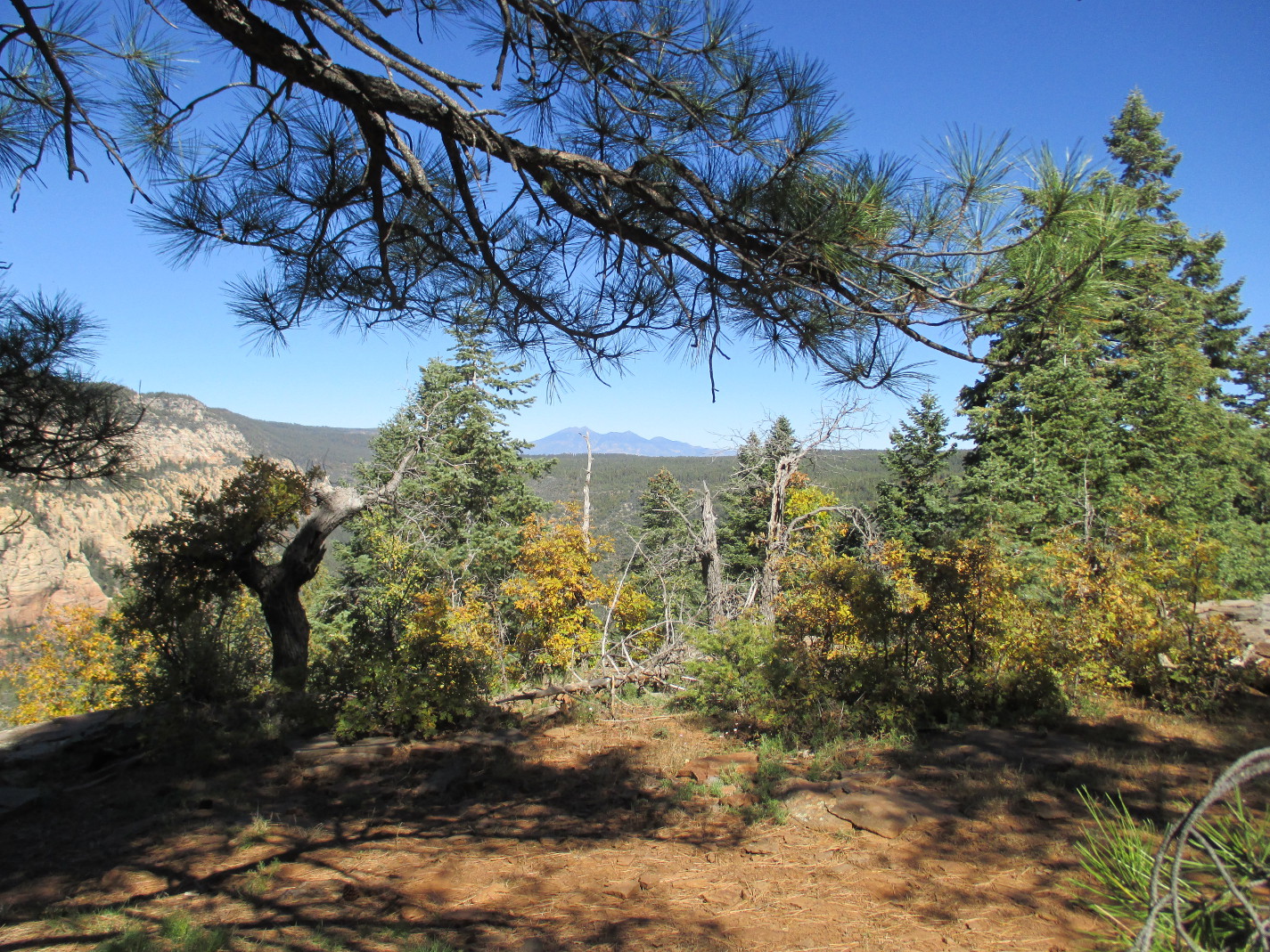
As we neared the Thomas Point Trailhead we came to an opening which allowed us a view across Oak Creek Canyon to the white cliffs on the other side.

View across Oak Creek Canyon from Thomas Point
This seemed a good spot for a group photograph, so we posed on the rim of the canyon.

Left to right (front row): Betty Wolters, Kwi Johnson, Dolly Yapp, the author; 

(back row): Lila Wright, Connie Woolard, Daisy Williams, David Beach 
and Miriam Sterling – photograph by Name Withheld
The old road we were following continued on past this point for a short distance to end at a man-made rock wall (left), seemingly serving no other purpose than perhaps to mark the Thomas Point Trailhead. In any case, that is what I have always used it for. The point is just a hundred yards or so wide at this spot and when I turned from taking the photograph of the wall, I had to walk only a few yards for the following terrific view of Oak Creek Canyon looking toward Sedona.

Looking down Oak Creek Canyon toward Sedona from Thomas Point
Intrigued by the scattered spots of fall color in the above photograph, I zoomed in for a closer view (right) of one particularly noticeable area showing a range of colors.

It was just a little after 1100 and we normally don't stop for lunch on our hikes until 1200. But we would not find a better viewpoint anywhere on this hike, so we ate early and enjoyed the view.

As we were departing the point, I paused for a final look at the San Francisco Peaks prominent on the distant horizon.

The San Francisco Peaks seen from Thomas Point
On the return hike we saw, along with many more of the showy goldeneye flowers, a few asters and an isolated Indian paintbrush.

Clump of asters
Indian paintbrush
The oak trees scattered along our trail were in formal fall dress, proudly showing off their colors among the green conifers.

Oak trees in seasonal color among the conifers
Farther along the trail, we saw entire meadows peppered with showy goldeneye flowers.

Meadow peppered with showy goldeneye flowers
We arrived back at our parked cars at 1330, a few minutes over fours from the time we started the hike.

According to my GPS, the hike distance was 5.4 miles, the total ascent was 523 feet and the highest elevation was 6703 feet.

The map (below) shows the hike to Thomas Point in red and the return trip in blue. Where the tracks are coincident only blue is visible.


Saturday, October 12, 2013

Sandys Canyon, Fisher Point and Walnut Canyon


By 12 October 2013, we had begun to migrate our weekly hikes from the high country down toward the Verde Valley area for the winter season. Last weeks hike had been in the Inner Basin of the San Francisco Peaks; this week we would hike in Sandys Canyon and Walnut Canyon southeast of Flagstaff.

Following our by now normal routine of starting our hikes at 0700, I was at the meeting place and ready to go at that time. Alas, only Connie Woolard had shown up. Somewhat puzzled at the absence of other hikers, we waited an extra ten minutes, but then headed out to do the hike by ourselves. It never occurred to me to check the schedule for the starting time. After all, had I not made it out myself?

We were almost to Flagstaff when my cellphone rang. It was one of six additional hikers who had met at 0800, the time actually published in the schedule. Connie and I decided to wait at the Circle K Station located at the I-17/Lake Mary Road interchange for the others to catch up.

We thought it would be a rather boring wait, enlivened only by people watching; however, we were surprised to find a prairie dog village located between the service station and the freeway, actually within the road right of way on the ramp that exits from I-17 to I-40 heading east. The fellow shown here (right) is actually located outside the perimeter fence for the freeway right of way. However, he was closer to us and the only one I could photograph easily.

When the other hikers arrived, we immediately headed on out Lake Mary Road to the Sandys Canyon Trailhead. According to notes I had made from a previous hike, it should be located between five and six miles from the I-17 exit. We found the actual distance to the turn off from Lake Mary Road to be 9.5 miles. One still exits as before at the Canyon Vista Campground. Now, however, trailhead parking has been relocated to just outside the campground and one must walk about two tenths of a mile through the campground to the trailhead. The previous parking area which was located near the trailhead, is now blocked off by large boulders. Incongruously, a sign, not visible in the photograph (above left), is still posted warning people that parking in the lot is not permitted after 8 PM. The campground itself was deserted, apparently having been closed due to the current government shutdown.

We stopped near the trailhead at a sign describing the Arizona Trail, a bit of which we would be hiking on today, for a group photograph.

Left to right: David Beach, Frank Lombardo, Daisy Williams, Jeanmarie 'Jeannie' Haney (kneeling), 
Connie Woolard (almost hidden), the author and Betty Wolters
From the trailhead at Canyon Vista Campground, the trail runs for half a mile along the western rim of Sandys Canyon. While traveling along the rim hikers are afforded excellent views down into the canyon and all the way to the San Francisco Peaks.

Looking from the western rim of Sandys Canyon across the colorful fall foliage in the canyon 
and on to the San Francisco Peaks beyond
After traveling along the rim for about half a mile, the trail turns sharply right and descends steeply into Sandys Canyon. It might be worth noting at this point that one can avoid Canyon Vista Campground altogether by turning off Lake Mary Road onto Forest Road 9478Y about 0.7 miles short of the campground turnoff and driving about one-tenth of a mile to a large parking/turnaround area. One can park there and take a marked path about 150 yards to this point. But if you do you will miss the views along the rim of the canyon, one of the high points of the hike.

This alternate access point was explained to us by a local resident we met while he was out walking his five or six dogs. After a brief conversation, we thanked him and proceeded down into the canyon, descending about 150 feet in three-tenths of a mile. We then traveled along the canyon floor for another six-tenths of a mile to connect with the Arizona Trail which we followed for about a mile to the junction with Fay Canyon. The area is labeled on maps as both Lake Mary Valley and Skunk Canyon. In any case it is the large flat expanse where Sandys Canyon and Fay Canyon come together. Walnut Canyon starts here, at Fisher Point, carrying the runoff from Fay Canyon and Sandys Canyon.

Out of curiosity, I used Google Earth to trace Walnut Creek which flows down Sandys Canyon. The Creek starts on the north slope of Mormon Mountain and flows northwest through Upper Lake Mary and Lower Lake Mary, turns north/northwest to flow through Sandys Canyon, then east/northeast through Walnut Canyon. It crosses I-40 near Winona, continues north to pass west of Cinder Mountain and empties into the San Francisco Wash near Leupp Road north/northwest of Cinder Mountain. San Francisco Wash in turn empties into Padre Canyon which empties into Diablo Canyon. Diablo Canyon then carries the runoff to the Little Colorado River at Leupp.

Although we intended to climb to Fisher Point Vista, we decided to first follow a trail that leads down Walnut Canyon to where we thought it ended about three-tenths of a mile ahead. This was based on a hike that some of us did in 2009. However, we found a sign posted along the trail that indicated it now ended one mile ahead. We could go that far, so we continued.

On the way we stopped for a few minutes to investigate a cave formed by an ancient rockslide. The photograph (right) shows clearly how the cave must have been formed. We thought it was probably only a shallow opening, going back just a few feet. 


But when we entered we found that we could travel without difficulty, upright all the way, for at least 150 feet before we came to a very narrow section where, as shown here (left), only a very skinny person would be able to pass. We turned back.

Leaving the cave, we traveled on down the canyon, pausing frequently to admire the fall foliage and the colorful rocks of the canyon walls.

Colorful rock cliffs and fall foliage in Walnut Canyon
After hiking down the canyon for about a mile but seeing no evidence that the trail ended anywhere nearby, we wondered whether it might now extend all the way to the Walnut Canyon National Monument, about another 8.5 miles. But that was certainly not a project for today, so we found a sunny spot to eat and then turned back toward Fisher Point.

From the grama grass-covered flats below Fisher Point, it is a winding mile-long, 432-foot climb to the top. The view from the top is certainly worth the effort. We could look down into Walnut Canyon to the east while straight ahead, looking south, we had a panoramic view of Lake Mary Valley (or Skunk Canyon) over 400 feet below.

View from Fisher Point Vista showing the flats (Lake Mary Valley) below
The red dot in the above photograph indicates the intersection of the trail with the Arizona Trail which runs right up Fay Canyon from here and left up Sandys Canyon, the way we will go. The blue dot near the center of the photograph shows where a short cut leaves the trail to connect with the Arizona Trail about a hundred yards up Sandys Canyon from the junction shown by the red dot. Close inspection will show five riders on the trail at bottom left.

Just as we started our descent from the vista, we found a patch of the most colorful foliage of the entire hike, a small patch of deciduous trees nestled under the conifers.

Fall foliage beneath the conifers
It was now around 1400 and we wasted no time in making our way back down the trail to connect with the Arizona Trail for the trip up Sandys Canyon and back to the trailhead. We didn't want to be too late returning home as the days were getting shorter and dark came early. Additionally it had been a fairly long hike and we were getting hungry, or at least I was.

When I arrived home and downloaded my GPS data, I found that the first data was recorded at 0938 and that we had arrived back at our cars at 1612. In other words we had been on the trail for 6 hours and 35 minutes.

The total round trip hike distance was recorded as 9.5 miles with an elevation gain of 432 feet (highest to lowest), a total ascent of 1198 feet and a highest elevation of 7057 feet. Because of the large difference between total ascent and the highest to lowest elevation readings, the trail profile, showing all the ups and downs, is shown below.

The GPS track for this hike is shown in red on the included map (below). The map also shows the alternate access to Sandys Canyon Trail.


Saturday, October 5, 2013

Inner Basin Trail to Waterline Trail and South


We had hiked the Inner Basin Trail from Lockett Meadow to Waterline Trail and then continued north on Waterline to Bearjaw Trailhead just three weeks ago. At that time there was the barest hint of fall shown on a few early-turning bushes along the trail between the Inner Basin and Bearjaw. We thought that now, on 5 October 2013, the aspens should be about at their peak, so we headed back to Lockett Meadow for another hike through the aspen forest to Waterline Trail. This time we would hike as far south on Waterline as we wished and then return by way of an old road to the lower end of Lockett Meadow. I had plotted the track we intended to take on a topographic map and transferred it to my GPS, so we were confident that we knew the route along the old road and, even if we didn't find it, we could return to the meadow without any problem except perhaps some extra time.

There were only five of us for this hike and we all piled into Kwi's car for the trip to the trailhead, arriving there at 0900. At Lockett Meadow, we found that most of the fee camping sites were occupied, but that was not a problem as we were headed for the no-fee parking at the Inner Basin Trailhead. Even that was rapidly filling up when we arrived. But there was still room for us, and we were soon headed up the trail.

We had noted three weeks ago that this section of the trail had fairly recently been rerouted. This time I looked a little more closely and decided that part of the new trail had been constructed at a firebreak where the 2010 Schultz fire had been contained. Work done to create the firebreak and contain the fire probably made construction of that section of trail relatively easy.

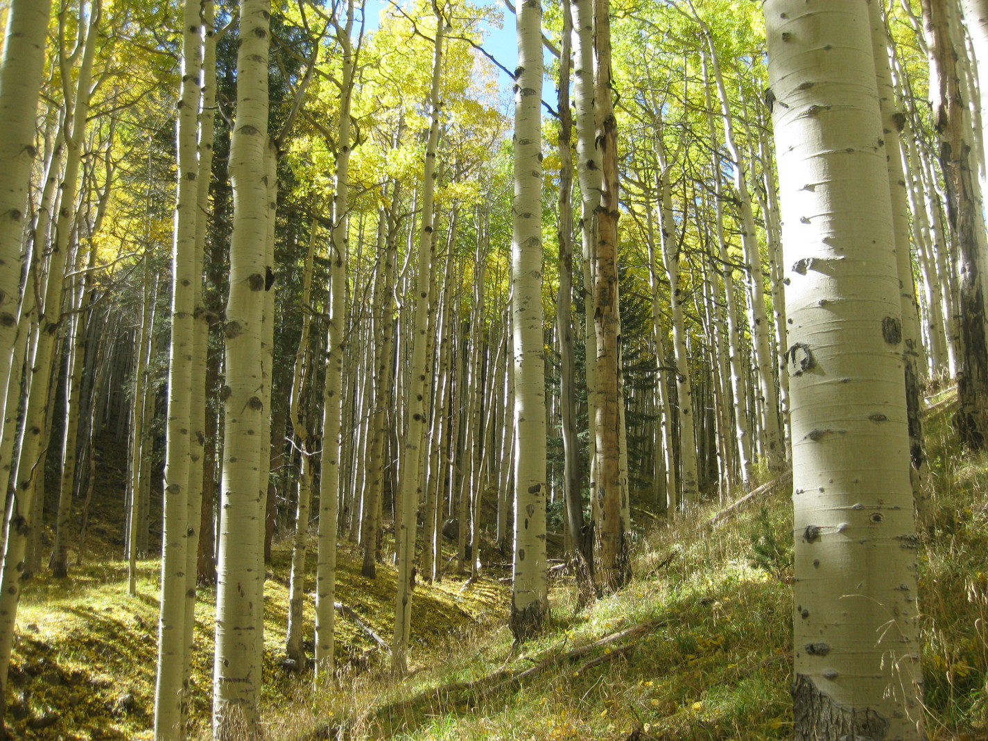
We moved rapidly past the section of trail constructed along the firebreak and on into undamaged forest, anxious to reach the switchbacks that would take us up the mountain through the aspen forest to connect with Waterline Trail. The aspens would tell us how well we had timed our hike for the fall colors. We were soon among them and our timing could not have been better. The forest was absolutely splendid. The clear blue sky could be glimpsed through the sun-drenched golden canopy provided by the aspens. The striking white trunks supporting this canopy were planted in a light green carpet of grass while the darker blue-green of scattered fir trees, although contrasting sharply with the lighter colors, blended smoothly into the overall scene.

The aspen forest between Lockett Meadow and Waterline Trail
This part of the recently-constructed section of trail (right), switchbacking its way through the aspens and rising about 300 feet in 0.7 miles, is alone worth the trip. I have never found a hike anywhere that I enjoy more than this short section of the Inner Basin Trail.

While still in the aspens we paused for a group photograph.

Left to right: Kwi Johnson, Lila Wright, Connie Woolard and Frank Lombardo
When we arrived at Waterline Trail we stopped for a snack and a short rest. While paused we discussed what we knew about the history of Waterline Trail. Basically, that turned out to be very little more than that the road it follows is used to service a waterline that carrying water to the city of Flagstaff. We knew that it started at Schultz Pass, ran along the slope of the mountain east of Schultz Peak and Doyle Peak, crossed the Inner Basin near Jack Smith Spring and continued north along the slope below Rees Peak to end in Abineau Canyon. No one had a good idea as to when the waterline was constructed.

However, Lila Wright later found that the City of Flagstaff has a website containing a brief history of the water system.1 According to this source, “a 12 mile, 6-inch clay pipeline was constructed from the Inner Basin through Schultz Canyon to a 2.5 million gallon reservoir located north of Flagstaff along what is now Schultz Pass Road2” was constructed after the city was incorporated in 1884. I have no date for when the waterline from the Inner Basin actually went into service, but it would likely have been soon after 1884. Also I do not know when the waterline was extended north from Jack Smith Spring around Rees Peak to capture water from the north slopes. However, I have hiked that section of trail all the way to Abineau Canyon and did not notice any remains of clay pipe such as are seen all along the trail south of Jack Smith Spring. That would seem to indicate a later date of construction.

After our short break we headed south on Waterline. This section continues through the aspen forest and is a very pleasant hike.

Looking down Waterline Trail just south of Jack Smith Spring
We knew that we would soon enter the 2010 burn area, so were determined to enjoy the unspoiled forest while we could. Still, even after we entered the burn area, about 1.1 miles from the junction with Inner Basin Trail, we found Waterline a rewarding hike. We found ourselves following along the edge of the burn area and passing in and out of untouched sections of forest and those that had been completely destroyed. Each has its own attraction.

An area untouched by the burn seen along with a devastated area
In the burned-over areas recovery was now well underway with some areas covered with lush grass and others thick with new-growth aspen.

Showing new-growth aspen and grass growing in the burn area
A few minutes before 1200, our planned lunch time, we came to a sunny spot sheltered from the brisk, rather chilly wind and stopped a little early for lunch. After eating, we decided to head back to the trailhead. We knew that the narrow, one-lane road into Lockett Meadow would be heavily congested on the way out and we were not absolutely certain that the old road along which we had plotted our return hike was all still there. Some maps had shown it as not going all the way to Waterline Trail; we might have to hike cross country. Lastly, it would be a good two-hour drive back to Cottonwood after the hike was done. So we turned and headed back to where we thought the old road ran, just at the beginning of the burn area.

We had some good views along the way. Highway 89 was visible below us and we could see the Painted Desert beyond Sunset Crater and across the Navajo Reservation.

Looking across the Navajo Reservation to the Painted Desert
We easily found the old road we planned to follow and followed it for 1.6 miles back to where we were parked. It was steep running down the mountain, but otherwise in excellent condition. And it did extend all the way to Waterline Trail. We encountered several hikers and hunters walking up the trail but no vehicular traffic at all except for a single ATV parked behind a tree just above the road near Waterline Trail. When we reached the foot of Sugarloaf Mountain, just where the road turns west to make the final descent to Lockett Meadow, we encountered a gate across the road and the following Forest Service sign (left) that explained the general lack of vehicular traffic.

As we made the final descent into the meadow, we caught our first glimpse of Humphreys Peak, looming at the west end of the Inner Basin. Lined up along the north side of the Basin were Abineau shown dimly through the trees in the center of the photograph and Rees Peak seen at the extreme right in the same photograph.

Humphreys Peak (center)
Abineau (center); Rees (right)
The road below the gate blocking vehicular traffic was quite busy and we kept having to step aside to permit cars to pass. Busy dodging cars and sorting out and identifying the peaks, I was largely unaware of scenery closer in. However, Lila drew my attention to the brilliant colors displayed by a small group of aspens just off the road in the following photograph.

Brilliantly-colored aspens at Locket Meadow
When we arrived back at the meadow, we found that it was even more crowded than when we had started our hike. All camping slots were filled and the trailhead parking area was overflowing, with cars parked haphazardly along the narrow roadway.

Lockett Meadow camp slots and trailhead parking were filled to overflowing
One thing we noted immediately on entering the camping area was that, despite the overflow crowd, there was no line outside the toilet. Closer examination, however, revealed a neat sign on the door telling us that it was out of use due to the current government shutdown. That and the inability to access the USGS National Map Viewer, which I use to create maps for my hike reports, are the only problems I have personally encountered during this first week of the shutdown.

My final GPS statistics show that we hiked for 2 hours and 51 minutes and stopped along the way for 1 hour and 51 minutes, for a total time of 4 hours and 42 minutes. The total round trip hike distance was recorded as 7.0 miles, the total ascent was 1554 feet and the highest elevation of 9,420 feet.

The GPS track for this hike is shown on the attached topographic map (below).


1 http://www.flagstaff.az.gov/documentcenter/view/14325

2 http://www.flagstaff.az.gov/documentcenter/view/14325

Saturday, September 21, 2013

Finding the Vultee Plane Crash Site


Several members of the Skyliners hiking group had long wanted to visit the site of the 1938 Vultee plane crash. A 2011 article in the Verde Independent1, a local newspaper, had whetted our interest and we had already made one unsuccessful attempt last February only to be foiled by an 18-inch snow cover on top of the mountain. Now, reinforced by the accompaniment of Bill Reller, who had visited the site a number of years ago, we set out for another attempt.

Several members of the group left from Cottonwood and drove to Sedona where we met with others at the Burger King Restaurant. From there we continued north on Hwy 89A to meet the final members of our group at Indian Gardens in Oak Creek Canyon. We then proceeded on up the canyon toward Flagstaff, turning left onto Forest Road 535 between mile markers 390 and 391. The best directions we had to the site started at the East Pocket Lookout Tower and we originally planned to start our search from there. The distance to the tower from where we first turned onto FR 535 turned out to be 23.1 miles. The first 5.5 miles (FR 535) was well maintained, the second 3.3 miles (FR 536) contained a few large mudholes that we had to maneuver around and the third section (FR 231) was well maintained but with a few rough spots. With care, the entire route could have been traversed in a normal passenger vehicle, although a high-clearance vehicle is recommended.

As noted, our original intent had been to drive all the way to the lookout tower and start our search from there. The very sketchy directions we had used the tower as a reference point. We found out later that it is not possible to drive all the way to the tower; the road is blocked by a closed gate about 0.5 miles short of it.

As it were. Bill Heller remembered turning off FR 231 for the crash site before actually reaching the tower. That was true; however, we turned off about 1.4 miles too soon. About 0.4 miles after turning off, we reached a spacious parking area, located right on the rim that, that provided an excellent view of the country below us.

From the lot where we parked – looking across Sedona and the 
red rock country
This seemed as good a place as any for a group photograph.

Left to right (standing): Jerry Showalter, Lila Wright, Miriam Sterling, Mike 

McDaniel, Bill Reller, Anita Jackson, Nancy Imus; (kneeling/sitting): 
the author, George Everman, Akemi Tomioka and Dolly Yapp
– photograph by Name Withheld
Although it was now pretty obvious that we were not as near the crash site as we had planned, we decided to leave the cars and start our hike from here anyway.

It was not as though the crash site were unknown; a good number of reports are to be found describing previous visits to it. However, nowhere in any of these reports had I found location coordinates or a good description of how to get there. I think that is partly because the place is so deceptively simple to find once you know where it is. In our case, we were sure that if we just traveled along the rim toward East Pocket, we could not fail to find it.

As we made our way east along the rim, we were constantly treated to great views out over the red rock country. The below photograph, looking across Sedona to Airport Mesa, shows faint contrails from an air show currently in progress there.

Contrails above airport, see slightly right and below center
After traveling for about half a mile along the rim we were once again very close to FR 231 on our left. It grew farther away as we continued along the rim but then grew closer again until, about 1.3 miles from the parking lot, we found ourselves actually hiking on the forest road. We continued along it for about 0.2 miles until we came to an old road, now closed to vehicular traffic, that I later learned was old FR 231, that once led to East Point Tank. Looking straight ahead on the main road (FR 231), we could see a gate across that road about a hundred yards ahead. Someone remembered the gate from a previous trip to the area and thought it was very near the crash site, so we turned south on old FR 231 road and then left it after a short distance to follow more closely along the rim.

When we had hiked far enough that we thought we should have encountered the crash site, we decided to turn northeast and hike to the tower. We could eat lunch there, reorient ourselves and get a fresh start on our search. Additionally, we had been told that the tower would be manned and that we might be able to arrange a visit to the observation booth. That turned out to be the case and the attendant was quite helpful in providing us some additional information to aid us in our search.

After everyone had visited the tower and we had eaten lunch, we headed down FR 231 to the gate and the junction with old FR 231 just beyond it. It turns out that we were actually headed in the right direction when we had previously turned south on that road. We just hadn’t gone far enough. At the tower, we were joined by a Lady from Mesa, AZ who had hiked up A B Young trail and who stayed with us for the remainder of our hike before heading back the way she had come.

The distance to the junction from the tower proved to be just 0.6 miles, as measured by GPS, and on reaching it we once again headed south along the rim. This time we followed the old roadbed for 0.3 miles, to the top of a fairly steep hill, before it veered to the east and we left it to travel south along the rim. It was a lot farther than we had expected and we were about to turn back, thinking that we had simply missed it among the numerous ferns growing along the rim and now sporting their fall rust color. Fortunately, just at that moment someone spotted the small white cross erected at the site in 2011 by Peter Vultee, Jerry's son, and his cousin John Vultee2. We had traveled, following closely along the rim as we did, some 1.3 miles from FR 231. Much farther than any of us had thought. The trip back, with no longer any need to hug the rim, was a little shorter, about 1.1 miles.

Memorial cross erected at the Vultee crash site
The blowup displayed below shows the plaque mounted in the center of the cross.
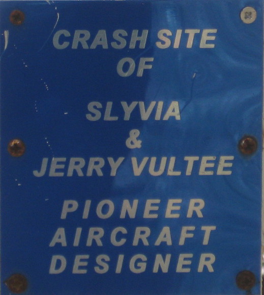
Enlarged view of plaque mounted on cross
The remains of a major part of the airframe assembly can be seen to the right of the cross in the above photograph and debris is scattered over a relatively small area extending from there to the left of the cross. This debris field is seen from another angle in the below photograph.
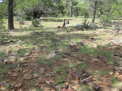
Vultee crash site debris field
The major part of Jerry Vultee's life and career, along with the history of the company he founded are described in an article appearing on the Davis-Monthan Aviation field Register web page3 and the aforementioned article published in the Verde Independent speculates on why he was flying in such bad weather. I will not elaborate further here, but will leave it to interested readers to review those sources themselves.

Just a few yards beyond the site, we had an exhilarating view from the rim of the Dry Creek watershed. Although we looked very hard, we could not see Vultee Arch from the rim, finally deciding it was obscured from our view by the west wall of Sterling Canyon. Later, I did determine that it is 1.5 miles from the crash site at a bearing of 1630 true. The photograph below shows the rough, beautiful country spread out below us.

Dry Creek watershed viewed from the Vultee crash site
On leaving the site, we took the most direct route back to the junction of FR 231 with old FR 231. Meanwhile, three hikers had gone on ahead to retrieve vehicles and meet us at the junction. We all then drove back to the parking area to retrieve a vehicle still parked there. What had been intended as a stroll in the woods, so to speak, become a good hike by the time we had finished and we surely would not have found the site at all without the help of Bill Reller and the information provided by the tower attendant.

The following map (below) shows the immediate area of the crash site and the fire tower. Forest Road 231 is shown in purple, the short drive from FR 231 to the rim parking lot is shown in yellow, the dark green line shows our hike to the tower and the red line shows the most direct route from FR 231 to the crash site. The light green line is A B Young Trail. It is 1.1 miles in length, so a 2.2 mile round trip hike will get you from a car parked at the junction to the site and back. The next time we will know this.

Close up map of the Vultee Crash Site and the East Pocket area
While we were rambling around searching for the crash site, I found a few colorful flowers. The most attractive of these is shown here (left). I am not sure, but I think it may be a desert dahlia.

Meanwhile, Akemi had become fixated on mushrooms. She photographed a number of different specimens, sending those she found most interesting to me for inclusion in the hike report.
Below are Akemi's mushroom photographs. The colorful, spherical one (first two photos below) is poisonous and psychoactive. It was featured in a recent issue of Arizona Highway Magazine4 and erroneously listed as edible, causing that issue to be recalled.

Fly agaric or fly amanita mushroom
Of the two photographs below the one on the left was included because it is shaped like a heart. The one on the right, on the other hand, turned out on closer examination to be the author taking a nap.

Heart-shaped mushroom
The author posing as a mushroom
We actually hiked 5.4 miles. But just hiking from the FR 231/old FR 231 junction to the crash and back would be 2.2 miles with an elevation gain of 210 feet and a highest elevation of 7025 feet.


1 http://verdenews.com/main.asp?SectionID=74&SubsectionID=114&ArticleID=43609
2 http://verdenews.com/main.asp?SectionID=74&SubsectionID=114&ArticleID=43609
3 http://www.dmairfield.com/people/vultee_je/

4 http://arizonahighways.wordpress.com/2013/09/13/arizona-highways-magazine-issues-statement-about-october-issue/