Saturday, March 10, 2012

Towel Creek Trail


Directions from Cottonwood are as follows: drive through Camp Verde on Hwy 260, turn right on Fossil Creek Road (ten miles from the Hwy 260/I-17 interchange at Camp Verde) and continue for another 8.9 miles to arrive at the Towel Creek Trail Trailhead. There is no designated parking area; however, the road is wide enough to permit parking alongside.  These directions are for reaching the trailhead; however on this hike, we actually stopped just past Needle Rock, parked at a wide open area on the east side of the road about 200 yards short the actual trailhead.  After parking, we climbed over a fence, bypassing a locked gate, followed a road across the Hackberry Springs Wash and then turned south, still following an old road, to connect with the Towel Creek Trail.  The way we went is actually shown on the USGS overlay for Google Earth as being Towel Creek Trail.  I think the trail must have been rerouted sometime in the past to avoid a Ranch house located just across the wash from where we parked.

After crossing the gated fence, we paused for a group photograph with Needle Rock in the background before continuing our hike.

Left to right: Fran Lind (kneeling), Miriam Sterling, Becky Fowski, George 
Everman (kneeling, front), Bob Wakefield (kneeling, behind George), 
Jim Manning, Annie Johnson (kneeling), Lila Wright, Dave Beach, 
Akemi Tomioka (kneeling), Janet Wakefield, Dolly Yapp (kneeling), 
Name Withheld, Daisy Williams (kneeling), Anita Jackson, 
Mary Gavan and the author (kneeling)
As we traveled south along Hackberry Springs Wash toward the connection with Towel Creek Trail we encountered a herd of horses (second photograph below).  They were very friendly but lost interest once it was determined that we were not dispensing snacks.  Connecting with the trail, we continued along the southeast slope of Hackberry Mountain.  At first we were actually on the slope of a thousand foot lower formation that separated us from Hackberry Mountain proper and shielded it from view.  It was not until we passed Pombo Tank, over half way to Towel Tank, that we could actually see Hackberry Mountain.  We were still traveling southeast and now had Hackberry Mountain in view on our now right and could see the Towel Peaks directly ahead.  When we reached Towel Tank, located between Hackberry Mountain and the Towel Peaks, we would turn west and go directly between those two formations, following Towel Creek Trail on toward our goal, the Indian Ruins located near the Verde River.

On arriving at Towel Tank, we were confronted by a herd of cattle.  Like the horses we had encountered earlier, they lost interest as soon as it was determined that we didn’t come bearing edible goodies.  Pictures of both the cows and the horses are shown below.

Herd of cattle at Towel Tank.
The tank is located at the top of the saddle that separated Hackberry Mountain to the north from the Towel Peaks to the south.

Herd of horses encountered between the ranch house below Needle 
rock and Towel Trail
Towel Tank lies in the saddle that separates Hackberry Mountain to the north from the Towel Peaks to the south.  To this point we had climbed gently along a rocky trail from Fossil Creek Road.  From here we would follow an equally rocky trail sloping a little more steeply down to the Indian Ruins.  The picture shown on the next page accurately illustrates the type and condition of the trail for most of its length.  The picture was taken as I descended into a wash and shows the ascent on the other side.

Only six hikers intended to hike all the way to the ruins.  Some of the others had already visited them on a recent scouting hike and some simply wanted a shorter hike, so we separated not far beyond the tanks, with George, Akemi, Jim, Mary, Ellis and Becky continuing on.

The rocky Towel Creek Trail required close attention to footing.
About two-thirds of the way from Towel Tank to the ruins we came upon a short section of the creek that actually had a small trickle of flowing water.  There were no cattle in the area at the time; however, we saw plenty of fresh signs indicating it is heavily used.  Having just stopped for a rest and a snack break shortly before arriving at the flowing water, we did not pause, but pressed on toward our goal.

Form here the trail was a little less discernible, although we found occasional cairns placed along the way.  Fortunately, all the false trails made by cattle soon come to an end and it is then apparent that one has made a wrong turn.

On reaching the area of the ruins it is necessary to cross the wash and bushwhack up the hillside on the other side to access them.  At the point where we left Towel Creek Trail (2.1 miles short of the river) we could see both ruins set in the cliffs across the creek.  Easing our descent to the creek was a side trail that angled upstream and descended to the bottom.  The way up to the ruins was fairly steep but open and we were soon settled in at the larger (westernmost) of them eating lunch.

The larger of the two ruins in the area
After lunch and my traditional nap we traveled the short distance eastward along the cliff face to look at the smaller ruin.

This is the smaller of the two ruins
I did nothing more than stick my head inside either of the ruins; they are both being used extensively by bats and the floors are deeply carpeted with enough nitrogen rich guano to keep the most avid gardener happy for several seasons.

We descended back to Towel Creek upstream from where we had ascended to the ruins and followed a wash up the slope to access the trail.  We should have returned the way we came; it would have been easier.  We made, primarily at my insistence, several stops during the rock stream climb back to Towel Tank.  I really didn’t realize how dehydrated I had become until I weighed myself before stepping into the shower that night and found that I was several pounds lighter than normal.

For some reason George had poker chips with him (Was he trying to get a game started?).

One of the other hikers who turned back early got his hands on one and left it squarely in the middle of a cow pile (right) for George to find on the way back.


After the hike I learned from Lila that the group that turned back early visited the Tee Pee Rocks on the way home.  This formation, a clustering of fumaroles related to an eruption of Hackberry Volcano about 7 million years ago, is located just off Fossil Creek Road about a mile from Hwy 260.

The following is quoted from an article by Steve Ayers in the Camp Verde Journal:

The unusual formations are called fumaroles. They are the result of hot volcanic ash falling on a surface that is saturated with calcium rich water, such as the shores of the former "Lake Verde." The water in the ground turns to steam and vents upward through the fallen ash.

Where the calcified water comes in contact with the ash a layer of cement-like material is formed. Over time, the softer ash around the vents is eroded, leaving the conical shaped vent pipes exposed.

The pockmarked holes are the result of water eroding the base of the cones as they slowly expose themselves to the elements.
The Cottonwood Basin Fumaroles resulted from an eruption of Hackberry Volcano that took place about 7 Ma {million years}, give or take a Ma.1

For a look at active fumaroles one has no farther to go than Salton Sea in Imperial County, California.  A shallow magma body underlying the area causes the activity there; carbon dioxide is released and conveys subsurface mud to the surface.  These fumaroles are located in a mud field and, although you can drive to the edge of the field, it is difficult to get really close to the fumaroles without sinking into the muddy surroundings.

Here is a shot by David Beach of the fumaroles at Tee Pee Rocks

Fumaroles at Tee Pee Rocks
Bob Wakefield got a couple of good flower photographs along the way.  He identifies them as a Desert onion and “possibly” as Indian Mallow or Abutilon palmeri.

Desert onion
Abutilon palmeri
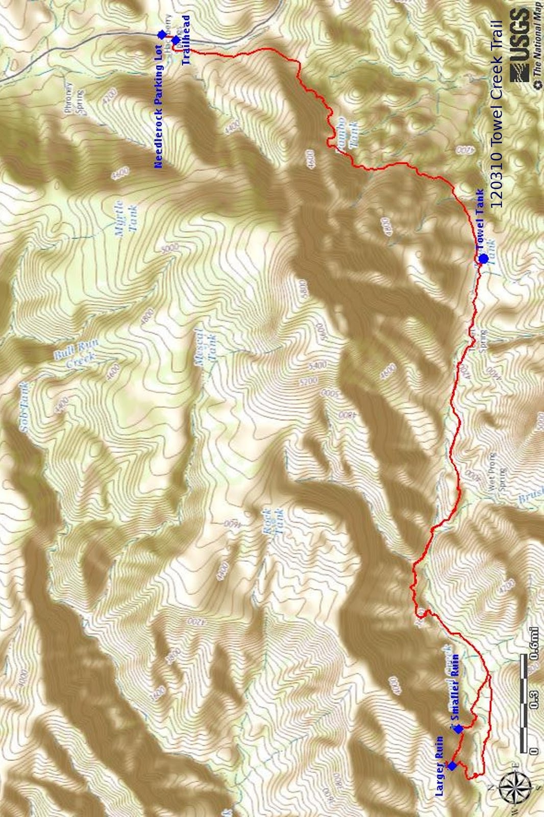
The GPS Track for this hike is shown in red on the included map (below). Note that the track shown is the actual present-day trail; it avoids climbing the fence at the locked gate. From the Needlerock parking lot, one walks a short distance south along Fossil Creek Road to join the trail at the official trailhead.

The round trip distance from the parking lot for this hike is 10.2 miles, the highest elevation is 4465 miles and the total ascent is 1959 feet.


1 https://www.cvbugle.com/news/2010/mar/23/a-violent-past-a-brief-history-of-verde-valley-vo/

Monday, March 5, 2012

White Pocket Trip

On Sunday, 4 March 2012, six Skyliners drove to White Pocket, camped overnight and explored the site the next day. We all met at George’s house and consolidated our gear into two high-clearance, 4-wheel drive vehicles, my pickup and George’s Jeep. We had been warned to expect very rough roads.

Left to right: Ellis Price, George Everman, Becky Fowsky, Jim Manning, Lila Wright and Gordon Bice
The neighborhood roadrunner (right) perched on the roof, view the proceedings with a seemingly skeptical eye. Did he know something we did not?

“But, what could a roadrunner know,” we said, as we climbed into our vehicles and headed up Oak Creek Canyon toward Flagstaff.

From Flagstaff, we took US 89 north and 141 miles from George's house, turned left onto US 89A. We crossed the Colorado River at Marble Canyon, below Lee's Ferry, and continued along the Vermilion Cliffs until we came to House Rock Road, 42 miles from the turnoff from US 89. Turning north on House Rock Road, we drove 9.4 miles before turning right on BLM 1017 (Pine Tree Road). About 6.2 miles from House Rock Road, we turned left (onto BLM 1087), continued about 4 miles and bore left (onto BLM 1086). From here it is about another 5.4 miles to White Pocket. The Google Earth map incorporated into this report (attached at end of report) shows the route from US 89Alt to White House.

The section of House Rock road we traveled on turned out to be relatively smooth and well-maintained. The roads after we turned off House Rock were less well-maintained but still passable. The surface was largely packed sand was delightful to drive on, although the ruts were deep enough in places to make us glad that we did have high clearance vehicles.

We arrived at the White Pocket parking lot early enough to have a quick look around before setting up camp for the night. To find a good spot, we drove on past the parking area for about a quarter of a mile and camped at the edge of a rock ledge. George and Akemi were sleeping in his Jeep, Jim, Becky and Lila had each brought a tent, while Gordon and I were sleeping in the open.

It was much colder than we expected that night. I used two sleeping bags and long johns and was still cold. When we arose the next morning at sunrise, the thermometer said 260 F and it must have been a few degrees colder during the night. But it was a beautiful morning, and George captured the sun it as slowly illuminated the countryside.

Sunrise at White Pocket
I felt dizzy and a little queasy that morning, barely eating anything for breakfast, and think that I must have picked up a bug along the way. We had come down a fairly steep sand dune on a deeply rutted road to reach the camping area from the parking lot and I didn't want to be driving while feeling dizzy, so asked Gordon to drive my truck back to the parking lot. He did and after that I left the driving with him for the rest of the trip. After all driving on the packed sand roads was a lot of fun, and I had gotten to do it on the way in.

When we arrived back at the parking lot, I was still feeling a bit down and stayed with the truck for a few minutes while the others entered White Pocket. However, after about half an hour I felt better and, camera in hand, went to see for myself the other-worldly vistas I had read about. I must say White Pocket does live up to expectations. Below are only a few of the many photographs we took during this visit.

White Pocket – photograph by George
White Pocket – photograph by Ellis
Gordon at White Pocket – photograph by Ellis
Akemi at White Pocket – photograph by George
White Pocket – photograph by Ellis
One could spend hours wandering around taking photographs at White Pocket. But enough for now, still not fully recovered from my early morning spell of queasiness, I made my way back to the parking area and found a nice sunny spot for a nap. Soon dead to the world, I knew nothing more until Lila woke me up an hour later and gave me some chocolate. I was now fully recovered.

The rest of our group soon straggled in and we headed back home, stopping at an old building, apparently with only a cat as resident, at the junction of BLM Roads 1017 and 1087 in Corral Valley to look around. George found a perch for his camera and we posed for another group photograph.

Akemi feeding the cat – photograph by George

Leaving the old building behind, we continued on down Corral Valley on BLM 1017 to connect with House Rock Road.

We made one more stop on the way back, to get a closer look at the old stone house built in the shelter of a fallen rock below the Vermilion Cliffs in Marble Canyon (photograph below).

Stone house built under a fallen rock – photograph by Ellis
A nearby sign was inscribed as follows:


We still had over 150 miles to go, so we didn't stay long to admire the old rock house, but were soon on our way home from what had turned out to be a very satisfying overnight trip.


Saturday, March 3, 2012

House Mountain via Turkey Creek Trail


We had House Mountain on the schedule for today, intending originally to hike in from the south to the house-like formation on one of the peaks. However, after some discussion, we decided to hike in from the north on Turkey Creek Trail. We would go as far as the crater and leave the peak with the house-like formation for another day. Ten hikers left the Cottonwood Safeway parking lot, drove to The Village of Oak Creek and turned off Hwy 179 onto Verde Valley School Road. We continued on Verde Valley School Road (and Red Rock Crossing Road - unpaved) for 4.0 miles to a rough dirt road leading off to the left. Another hiker, Mary Gavan, met us at this location and we drove on the rough 4-wheel drive road for about 0.6 miles to reach the parking area at Trail 92 (Turkey Creek Trail).

We didn’t linger long at the trailhead, but quickly donned our packs and headed out toward House Mountain. We paused for a few minutes at Turkey Tank and then continued along the trail. After crossing two distinct washes, the trail starts switch backing up House Mountain and the going becomes moderately difficult. About 1.25 miles along from Turkey Creek Tank, the trail makes a sharp turn to the right. A cairn is located alongside the trail just before the turn, followed by another just after the turn. What appears to be a trail leads east from the turn along the contour of the mountain. However, I can say from experience that it does not go very far.

After a short rest at the turn, we continued on up House Mountain on Turkey Creek Trail, coming out on top in a saddle atop the ridge about 260 yards and one more switchback ahead.

We stopped at the saddle for our midmorning snack and to take in the view looking out over the crater. To our left, southeast (about 112 degrees) from our position, the rim of the crater formed a peak that rises to almost 5100 feet. Across the crater to the southwest (about 225 degrees) we could see the house-like formation sitting atop the highest (at a bit over 5100 feet) of the peaks surrounding the crater.
After some discussion as to the possibility of continuing on to the “house on “House Mountain” we chose instead to climb the peak located to the southeast. We soon found that a lot of other hikers have made the same decision; a well-trodden path, with cairns helpfully placed along the way, leads almost to the top. It is a little rocky, fairly steep and one must dodge cactus along the way. However, all in all, it could be considered only a moderately difficult 450-foot climb from the saddle to the peak and we were soon enough at the top.

The time was just a few minutes past 1100, close enough to noon for lunch and we settled in to admire the views all around. From our perch we a panoramic view – the Black Hills to the west, Black Mountain and Casner Mountain to the northwest, the Red Rock Country northwest, north and northeast and Munds Mountain to the northeast. The Village of Oak Creek was directly to the east of our location. Dolly borrowed my camera and took a whole series of photographs that she intends to stitch into a panorama.

Looking across the Red Rocks at Sedona from atop House Mountain
After lunch we headed back the way we came, pausing briefly for a time-delay group photograph by Dolly, again using my camera.

Left to right: Dolly Yapp (not yet in position after pressing the camera 
button), Jim Manning, the author, Anita Jackson, Daisy Williams 
(kneeling in front), Mary Gavan, Lila Wright, Becky Fowski, 
Miriam Sterling, Name Withheld and Colleen Maktenieks 
– NOTE: We took the shot again in an attempt to get Dolly; 
however, she was hidden by a rock in that one and all I could see 
was her hat
The return trip went rapidly, with one casualty: Anita fell and damaged her finger. I didn’t see it before it was bandaged, but was told that it was ripped open and possibly broken. We called her son and had someone meet her on arrival back in cottonwood to take her to the doctor. This was the first time we have used Lila’s Hiker Emergency List to locate a next of kin. (NOTE: In case that sounds a bit dire, let me hasten to say that Anita was in good spirits and doing well when we reached the parking lot. She even refused to take an aspirin.)

My GPS read 8.39 miles when we arrived back at the parking lot; however, when I downloaded the track and measured it in MapSource, it measured only 7.4 miles. I don’t know the reason for the discrepancy, but I am voting for 8.39 miles.

The track for this hike is shown on the included map (below).


Saturday, February 25, 2012

89A to Lime Kiln Trail via Spring Creek


Twelve Skyliner hikers left the Safeway parking lot at 0800 on Saturday, 25 February 2012 for a hike along Spring Creek Wash. We drove north on Hwy 89A toward the Spring Creek bridge, turning on Spring Creek Ranch Road (a little-used road leading into an aborted (or at least delayed) housing development and parking just off the highway. From there we hiked 0.4 miles north along the east side of Hwy 89A to enter the wash at the bridge, crossing three fences along the way. As we followed the wash under the highway we noted a well-constructed bird nest tucked neatly under the bridge. I am not entirely sure what sort of bird built it; however it looked much like the owl’s nest that used to be located just above the main entrance to the local hospital. We saw no birds anywhere near.

Bird nest under the Hwy 89A bridge over Spring Creek Wash
We passed on under the bridge and continued up the wash, following cow paths along the side when possible. That is some of us followed the cow paths, others preferred the added exercise of hopping from rock to rock and just continued along the bed of the wash. I prefer the cow paths myself although, I must admit, the cows are prone to make their trails under low hanging bushes at times … good for brushing off flies if you are a cow, but sometimes difficult for hikers to navigate.

Soon after we left the bridge the walls on both sides of the wash grew higher and those of us following the paths along the bank had to cross over often when the stream bed veered too close to the wall. We continued in this manner for more than two miles before the wash widened and there was room for walking on both sides; even then some persisted in walking along the stream bed. About a mile before we came to our goal, the point where Lime Kiln Trail crosses Spring Creek Wash, we started to encounter dirt roads used by ranchers, campers and hunters. These roads played tag with the wash, approaching and veering away again, occasionally crossing over.

As we approached Lime Kiln Trail, we came to a fairly large herd of cattle, perhaps thirty or more, who seemed to have mixed emotions about interacting with humans. At first they appeared excited to see us, perhaps thinking that we were bringing something to eat. However, when we came closer, they hoisted their tails and scampered off.

Now on the east side of Spring Creek Wash, we hiked on past the point where Coffee Creek dumps into it, then crossed over and followed a dirt road up the west bank until we reached the Lime Kiln Trail markers. Finding ourselves a little distance west of the wash, we followed Lime Kiln Trail east until we crossed back over to the other side and found a nice spot for lunch. It was a little early, but we had just done a pretty strenuous 3.5-mile hike along a rocky wash, I had found a nice spot of grass (right, photo by George), and I didn’t hear anyone complain that they were not yet hungry enough to eat.

George seized the opportunity to pose us for our group photograph after my nap.

Left to right: George Everman (kneeling), the author, Donna Goodman, 
Jan Prefontaine, Daisy Williams (kneeling), Marvin Alt, Jim Manning, 
Colleen Maktenieks, Dolly Yapp (kneeling), Anita Jackson, 
Akemi Tomioka (kneeling) and Mary Gavan
We then packed up and headed back down the wash; this time taking the dirt road on the east side of the wash for a short distance.

The trip back was uneventful and we made very good time, although we did stop twice for short rest periods. Along the way, George found a gardening tool, carefully hidden in a tree near the trail. Donna examined it carefully (right, photo by George) and I thought she might be considering taking it home with her. We couldn't understand why anyone would have hidden it so carefully in the middle of nowhere. Were they using it to clear the trail? Perhaps the saw would have been useful for that, but this was not the sort of trail one used a rake to clear. In the end, George carefully replaced it where he had found it.

The hike was about 7 miles round trip. My GPS said 6.99 miles when we returned, Mary’s read just a bit higher, and the track when downloaded to the computer measured 6.4 miles. I have no explanation for the discrepancies. Elevation gain was negligible with only around 150 feet difference between the bridge at Hwy 89A and Lime Kiln Trail. I was back home just after 1400.

On the included map (below). today’s hike is shown in red; the blue line shows a section of Lime Kiln Trail.


Saturday, February 18, 2012

Apache Maid Trail


Seventeen Skyliner hikers set out to hike on Bell and Apache Maid Trails the bright, sunny morning of 18 February 2012. Hikers from Cottonwood met at the Safeway parking lot and carpooled to the Bell Trailhead; those coming from Sedona met us there.

Apache Maid Trailhead is located a little short of three miles up the trail from the Bell Trailhead at Beaver Creek Ranger Station. A parking lot (large but often filled) is located at the Bell Trailhead. To reach it take I-17 to exit 298 (Hwy 179/FR 618), otherwise known as the Sedona Interchange. From I-17 take FR 618 east for 1.5 miles to the Beaver Creek Ranger Station turnoff (FR 618A). Turn left and proceed 0.25 miles to parking area and trailhead. If the lot is full, turn around and go back about 0.25 miles toward I-17 on FR 618 and then turn right to park at the Bell Trail Overflow Parking Lot. You will have seen the sign on the way in. Toilet facilities are provided at both parking lots.

Don’t’ even think about hiking on Bell Trail unless you want a lot of company. It must be one of the most popular trails in the state. I have never been on it without seeing several other hikers. Once George and I came upon a Mexican lady struggling up the trail carrying half a watermelon on a silver platter. She was taking it along as refreshment for her family while they frolicked at the swimming hole. Apache Maid, which starts about three miles from the parking lot, is another matter. This is the second time I have hiked on it without meeting anyone along the way.

Bell Trail after leaving the parking lot on an old roadbed approaches and then follows northeast along Wet Beaver Creek. Soon a school (Southwestern Academy, Beaver Creek Ranch Campus) comes into view across the creek.

Perhaps a half-mile from the parking lot we came to the Bruce Brockett Trailhead. I was told that this trail leads to the Bell Trail overflow parking lot. According to the sign the lot is named Bruce Brockett.
That would mean that the hiking distance would be approximately the same whether one parked at the main trailhead or the overflow lot. The photograph shown here (right) was taken on the return trip and shows Bruce Brockett Trail leading up the bank to the right. It is not shown on any maps that I have seen, so I suppose it is relatively new.

To our right as we continued along the trail, the remains of an old irrigation system were to be seen between the trail and the creek. 

In places the system was just a ditch or canal.

Ditch or canal - part of irrigation system
In other places it seems to have been constructed of plastic pipe.

Plastic pipe - part of irrigation system
And even corrugated piping of the sort that is commonly used for highway culverts.

Corrugated piping - part of irrigation system
The section of the system that was composed of just a ditch (or canal) was unlined but in some places appears to have been reinforced by the installation of metal sheeting on the lower side.  

Reinforced section of open ditch
The system seems to have been abandoned several years ago.

Just under a mile along the trail we came to a petroglyph-covered rock beside the trail. Some of the markings look suspiciously recent in origin. Whether others were actually made by Indians I cannot say, but I think they probably were.

Petroglyph-covered rock
About another 0.8 miles along the trail we came to a trailhead marked White Mesa Trail (left). I have never been on this trail; however others have told me that it only goes a short distance up on the mesa and ends.

Shortly after passing the White Mesa Trailhead, we came to some Indian ruins located alongside the trail and overlooking the creek just a few yards away. Located as they are alongside the trail, which itself follows an old road, they ruins have been picked over and pretty much destroyed. About the most impressive thing that I saw along the abandoned roadway was what is left of an old pit house.

Ruins of an old pit house
Not more than half a mile beyond the Indian ruins, we came to the Apache Maid Trailhead and stopped for a snack. Apache Maid leads up to the Mogollon Rim from here while Bell Trail continues along Wet Beaver Creek, and some of our hikers wanted to go farther on Bell Trail rather than climb to the rim.

Apache Maid does look pretty scary from the bottom when standing at Bell Trail looking up to the rim high above. After some discussion, we split into two groups, a member of each group carrying a walkie-talkie, and agreed to meet back at this point at 1300. The walkie-talkies are a recent acquisition by the Skyliners and we were trying them out on this hike. We have found that as the number of hikers has grown, we often have a need to break into two groups and this gives us a way to keep in touch in the event one of the groups encounters a problem.
Before parting ways, we paused for the obligatory group picture.

Left to right: George Everman (kneeling), Jim Manning, Jan Prefontaine 
(kneeling), Daisy Williams (kneeling), Connie Woolard, the author 
(kneeling), Bill Woolard, Terri Johnson, Jan Johnson, Dolly Yapp 
(kneeling), Lila Wright, Jo Benkendorf, Akemi Tomioka (kneeling), 
David Beach, Becky Fowski, Mary Gavan and Karl Buckendahl
I hiked with the group going to the rim on Apache Maid Trail. It is in good shape all the way to the top and, as we had found out by hiking the entire length of the trail starting at the base of Apache Maid Mountain just a few weeks ago, the rest of Apache Maid is also in pretty good condition. I was struck by the consistent grade of the trail, accomplished by use of a lot of switchbacks. It hardly varied all the way to the top. At the rim we encountered a weathered sign (left) discouraging hikers from continuing beyond this point. Those of us who had recently hiked the trail thought it a bit misleading. Our experience was that it is relatively easy to follow the entire length of the trail just by paying attention to the wire-bound cairns placed along the way.

We had arrived at the top with plenty of time left to eat lunch and have a quick nap before heading back to meet the others at the junction with Bell Trail. I, of course, quickly dispensed with lunch and settled in for my nap (right), first unpacking and donning my windbreaker; it was a little breezy on the rim. I slept a good thirty minutes before being awakened by the noise of my cellphone alarm sounding. After I got home, George sent me a picture, taken by Akemi during my nap.

The views on the way up to the rim and from the top were the highlights of this hike for me. A couple of shots are shown below.

The San Francisco Peaks from Apache Trail at the edge of the Mogollon Rim
Looking down Wet Beaver Creek, across Southwestern Academy and 
on the distant mountains
The hike turned out to be only a little over eight miles (GPS reading) instead of the ten miles I had estimated. The section of Apache Maid that we hiked was 1.8 miles by GPS with an elevation gain of 1100 feet. The section of Bell Trail that we hiked to get to Apache Maid is essentially flat with around a 100-foot elevation gain.

Historical Note:

Hike Arizona.com (http://hikearizona.com/decoder.php?ZTN=384) presents two possible sources for the name Apache Maid: One is that troops, fighting Indians here in 1873, killed an Apache woman and took her baby with them to the fort at Camp Verde. This is coupled with an account that a young Apache girl came to the area with troops from Camp Verde in 1874 and that the mountain was named after her. Acceptance of this possibility thus requires the assumption that the “baby” taken to Camp Verde by the troops the year before was actually a young girl. The second possible source presented is that Apache Maid was named after a lost and starving young Apache girl who was adopted by one of the early settlers.

See the included map (below) for a track of this hike.


Saturday, February 11, 2012

Searching for Indian Ruins above Badger Springs


The Skyliners set out to explore Indian ruins we had been told are located on the mesa above Badger Springs Wash. We drove to Camp Verde and took I-17 south about 30 miles to Exit 256, the Badger Springs Exit. After exiting we turned back under the southbound lanes of the freeway and drove east on Badger Springs Road, crossing under the northbound lanes after about 0.4 miles, and continued for another 0.5 miles before turning the right to follow a road down Badger Springs Wash. Approximately 0.1 miles down the wash we came to a toilet, apparently installed and serviced as part of the Agua Fria National Monument.

We paused while those who felt the urge utilized the facilities and then, instead of following the well-worn trail on down the wash to the Agua Fria River, turned to climb the west slope of the wash to the mesa above. We had been told that the ruins we sought were located near the juncture of the wash with the river, but that they were best approached from the mesa. The path we followed was well marked for a short distance but grew ever fainter until, near the top, it vanished completely. The going was nevertheless not too difficult, just a bit rocky and with scattered cactus. We hiked along on top of the mesa, heading southeast toward where we believed the ruins were located. When we thought we were nearing the ruins we cut back to follow closely along the rim so as not to miss them. Conspicuously missing was any sign of Indian ruins.

Although we still hadn't seen any ruins, we did have a spectacular view of the Badger Springs Wash with the Agua Fria River, and before continuing our search, we paused to enjoy the view and take a photograph (below).


Junction of Badger Springs Wash with Agua Fria River – seen from the 
mesa above the was
We continued along the rim for about another 0.2 miles before deciding that we had either missed the ruins or they were a myth. Declining to waste any more time searching, we turned and headed back along the rim looking for a good place to descend into the wash. Our plan was to eat lunch at the mouth of Badger springs Wash.

Part of the group thought that the point where we had originally approached the rim looked like a favorable point to descend, others wanted to go back farther and look for an easier descent, so we broke into two groups. This would anyway give us a chance to test two walkie-talkies provided by David Nelson. The Skyliners had decided to purchase a pair for use in just such circumstances and David was able to provide, for a test, a ten-year old pair of the model we are considering.

The way down the hillside (perhaps I should say Cliffside) into the wash was steep and rocky. However, with care it was navigated successfully and we were soon enough walking down the sandy bottom of the wash toward its junction with the river. There we stopped to look at hieroglyphics visible on the canyon wall and wait for the group who were searching for an easier descent into the wash. All the while, successfully keeping in touch in touch by use of the walkie-talkies.

Although I had been this way before without seeing he hieroglyphics, they are really quite prominent once one knows to look for them. I took four different photographs (below) while we waited for the rest of the party to join us for lunch at the junction of Badger Springs Wash and Aqua Fria River.

Photograph 1 - junction of Badger Springs Wash with Agua Fria River
Photograph 2 - junction of Badger Springs Wash with Agua Fria River
Photograph 3 - junction of Badger Springs Wash with Agua Fria River
Photograph 4 - junction of Badger Springs Wash with Agua Fria River
We settled in at the junction for the better part of an hour, taking naps and eating lunch. Mary found a smooth, sunny rock, I found a nice soft bed on the grass with a handy log on which to elevate my feet for a nap, Marvin found a spot to his liking just across the river and the rest of the group settled on the sand, perched on rocks or selected spots of grass.

The other group having joined us and rested for a while, we decided to move on and hike a short distance down the river before returning to our cars. Before leaving the spot, though, we posed for a group photograph, taken by another hiker (part of a duo from Phoenix) who happened along at just the right time.

 Left to right: George Everman (kneeling), Miriam Sterling, Lila Wright, 
 Mary Gavan, Becky Fowski, Daisy Williams (kneeling), Marvin Alt 
 (rear), the author, Connie Woolard (kneeling), Bob Wakefield, Bill 
 Woolard  (kneeling), Name Withheld, Jan PreFontaine, Dolly Yapp 
 (kneeling), Anita Jackson (rear) and Cindy Covin
A short conversation with our guest photographer Chris Bailey and his wife Erica revealed that they were from Phoenix, hiked in the area frequently and had been to the ruins we were looking for. Chris even has a GPS track to the site that he is will willing to share. We traded e-mail addresses and he promised to send the track to me. He and Erica also indicated that they might join us for future hikes.

The rest of the hike was pleasant but uneventful. We crossed the river and hiked downstream about 0.2 miles along a well-worn path on the east bank before turning back. For the trip back to the cars we chose the easy route, directly up the wash. I think we had all had enough of the rocky mesa for one day.

The total hike was only 3.5 miles according to my GPS; the maximum elevation was 3467 feet and the total ascent was only 575 feet; however, the rocky ascent to the top of the mesa and the precarious climb back down provided some good exercise.


Saturday, February 4, 2012

Hwy 89A to Cornville Ditch


On Saturday, 4 February 2012, the Skyliners hiked from Hwy 89A at Page Springs Road to the Echo Canyon Winery and on to the old dam at Cornville Ditch. We met at the Cottonwood Safeway parking lot, drove about 7.5 miles north on 89A to Page Springs Road. Turning on Page springs Road, we proceeded about 0.28 miles to a parking area on the right. After parking we crossed Page Springs Road, hiked up Hidden Valley Road for about 0.32 miles and turned right onto Echo Canyon Road. We found ourselves to be high above Oak Creek, looking down at a stretch of the creek leading on to the settlement at the bend.

Oak Creek seen from Echo Canyon Road – photograph by Virginia Driscoll
For this hike we had permission to pass through private property owned by a friend of Mary’s, so were able to travel along Oak Creek to the old dam site; we thus continued on Echo Canyon Road past the winery and then cut across the private property to reach the creek. On our way, we actually walked through a covered patio attached to the landowner’s house and then were joined in the back yard by his cat for our morning snack. George, the cat’s favorite hiker, was having milk and cereal.

George sharing his snack with the cat – photograph by Virginia Driscoll
Upon reaching the creek we traveled along the bank to the old dam site. From there, rather than take the suggested route (the yellow track shown on the Google Earth map included on page xx13) back to the road, we chose to continue on along the creek bank and travel up a wash near Old Schoolhouse Road to return to Echo Canyon Road somewhere near the intersection with Hidden Canyon Road. George and I, lagging behind the main group, passed on by the wash, following an enticing cow path straight ahead, and wound up in the back yard of a private home. The house was located on Old Schoolhouse Road and, managing to avoid detection by the landowner, we passed quickly through the yard, took Old Schoolhouse a short distance to connect with Page Springs Road. We then contacted our hike leader by cellphone to let her know our status and returned to the parking lot by way of Page Springs Road.

Meanwhile, the main group of hikers had left the wash and climbed the slope on the other side; we could see them making their way along the ridge toward Echo Canyon Road as we hiked along Page springs Road.

We paused for a group photograph, taken by George using my camera and his small tripod, upon our return to the parking lot.

Left to right: Jim Manning, Lila Wright, George Everman (kneeling), 
Anita Jackson, Ellis Price, Mary Gavan, Kate Lockwood (kneeling), 
Donna Goodman, Virginia Driscoll (kneeling), Marvin alt, Colleen Maktenieks 
(kneeling), Bill Woolard, Connie Woolard, Daisy Williams (kneeling), 
Name Withheld (blue blurb), and Miriam Sterling – photograph by George 
with time delay
After returning home and uploading my GPS track to the computer, I found that we had crossed private property on the way down the creek to the wash and that the wash itself crosses a section of private property.

The easiest way to hike to the dam at Cornville ditch is to take Echo Canyon Road (red) to the green 4-wheel drive connector and use it to connect with the yellow path. The section of the yellow track that runs parallel to Echo Canyon Road is not really a trail; it is just the way we bushwhacked our way back on the April 2008 hike. However, this bushwhack route, following along the top of the ridge, offers great views of the area. The road may be easier, but the ridge is certainly worth the extra effort. Finally, I have included a small track (magenta on the map) that shows the route to an excellent viewpoint overlooking Hidden Valley.

The total distance for this hike was about 5 miles. That includes the side trip out to the Hidden Valley overlook. The total elevation change is approximately 550 feet.

The only information I found about what might be called “Cornville Ditch” by doing a quick online search was the following extract from a Wikipedia article:

The first settlers in the Lower Oak Creek area were Captain Andrew Jackson, a retired Confederate officer from Virginia, and his wife, Margaret, who arrived in the spring of 1876. Several other families including the Dickinsons, Munds, Copples, Pages, Mullhollands and Tiptons had followed by the autumn of that year or the spring of 1877. The settlers quickly built an irrigation ditch serving farms on the west side of Oak Creek.1

I was given the name Cornville Ditch by the, now deceased, leader of a 6 April 2008 hike to this site. Based on what she told me, I have since referred to the site as Cornville Ditch Dam. This hike was accordingly publicized as “Hwy 89A to Cornville Ditch.” However, while editing this book for me, Lila Wright, who grew up in the area, informed me that Cornville Ditch was located farther downstream in Cornville. She had no name for the ditch associated with the dam we visited, but did point out that it runs no farther than Dancing Apache (or D A) Ranch (east of the stream) and might be called “D A Ranch Ditch” or “Page Springs Ditch.”

I never really liked the name Cornville Ditch and neither Page Springs nor D A Ranch sound any better, so I shall henceforth refer to it as Dancing Apache Ditch. That will at the very least give it a more specific location.

Thus this becomes the hike from Hwy 89A to Dancing Apache Ditch.

The included map (below) included in this report shows the entire track (red line on the map) that I followed for this (4 February 2012) hike, including the part that crossed private property). I have also put together an alternative track that does not cross private property. This alternative route is composed of part of an April 2008 hike (yellow on the map), along with a small interpolation (green) along a 4-wheel drive road between Echo Canyon Road and the yellow track.


1 http://en.wikipedia.org/wiki/Cornville,_Arizona