Tuesday, July 25, 2017

Hike to the B-24 Crash Site on Humphreys


It was 28 September 2013, fall had arrived, and we were beginning to feel a distinct morning chill in the Verde Valley. A visit to the B-24 crash site on the western slope of Mount Humphreys was on our to-do list and now, while the weather was still moderate in the high country, was the time for it. None of us wanted to hike in snow or be exposed to the coming winter winds that could be expected on the relatively bare slope of Mount Humphreys at the tree line.

Seven of us left from Cottonwood at 0700, picked up two additional hikers from Sedona at the Hwy 179/I-17 interchange and drove directly to Snowbowl, where we parked in the lower lot. Humphreys Trail begins there and we would follow it for 2.9 miles (my GPS) before turning off to follow one of many very indistinct trails for another half-mile across the rock fields to the crash site. The following photograph was taken from the trailhead.

Left to right: Jerry Helfrich, Lila Wright, the author, Frank Lombardo, George 

Everman, Bill Woolard, Kwi Johnson and Connie Woolard 
– photograph by Name Withheld
The trail runs across an open meadow for a little over a quarter of a mile, passing under the Snowbowl ski lift (photograph below) to enter an aspen forest.

The start of Humphreys Trail, looking from the trailhead to the aspen forest
After entering the forest, the trail soon starts to ascend, at first rather gently, but then becoming steeper and rockier. About a mile from the trailhead, at a sharp turn to the left it enters the Kachina wilderness Area. This is the second of seven switchbacks encountered on the Humphreys Trail between the trailhead and the turnoff to the crash site. The turnoff is actually located exactly at the seventh of these. But that was still 1.9 miles away.

By the time we entered the Kachina wilderness, the aspens had largely given way to conifers, which predominated for the remainder of the hike. Previously we had found a wide variety of mushrooms along this trail; none were visible now. Flowers were also sparse, with only a single scraggly example (right) along the trail.

We had been moderately concerned about ice and snow and we did find some shaded stretches of trail where footing was pretty precarious. But we managed to avoid any major falls and eventually found ourselves approaching the turnoff to the crash site. It turned out to be relatively easy to spot, located precisely at a sharp bend to the right. One just steps across the log located to the left of the trail onto a much fainter trail, starting between two close set trees, leading north along the mountain slope. Note the arrow pointing out the trail in the below photograph.

Turnoff to the B-24 Crash Site marked by an arrow
This relatively short trail (I should say trails because there are a variety of them all leading to the same site) is rough in places, leading through short stretches of wooded area, interspersed by rough climbs over rock fields. We had turned off Humphreys Trail at an elevation of 11,041 feet according to my GPS and climbed about another 250 feet to the crash site itself. Almost all of the climbing seemed to be as we crossed the rock fields. We stopped for lunch just after turning off the trail. In the upper right quadrant of the below photograph, a lone hiker can be seen walking on Humphreys Trail. The bright red object seen bottom right is a hikers backpack.

Skyliner hikers eating lunch (bottom) and lone hiker walking on Humphreys 
Trail (upper right quadrant)
It took us some time to make our way over the rock fields, as we traveled slowly and carefully; we also stopped frequently to rest. As a matter of fact, we probably spent more time eating lunch, resting and just admiring the unobstructed views from high on the slope of Mount Humpreys during the short trip from Humphreys Trail to the crash site than we did hiking and climbing.

After a final sharp climb over the rocky slope we came to the edge of the crash debris field. The first major bit of wreckage we saw was a bucket seat we think was designed to protect a machine gunner from bullets and shrapnel. Lila and Kwi are shown below posing in the seat.

Lila in machine gunner's seat
Kwi in machine gunner's seat
The plane that crashed here at 0330 on 15 September 1944 was a B-24J Liberator. It was flying on a training mission from Bakersfield, CA to Albuquerque, NM with a crew of eight. The plane's specifications and serial number are listed below:

Designation: B-24J
Serial Number: 50890
Wingspan: 110 feet
Height: 18 feet
Length: 67 feet, 7 5/8 inches
Weight (empty): 36,500 lbs
Weight (fully loaded): 65,000 lbs
Engines: Four, 1200 hp, Pratt and Whitney, R-1830-65
Performance: Max Speed: 290 mph, Service Ceiling: 28,000 feet, Range: 3,000 miles
Armament: Ten 50 caliber machine guns
Crew: 10.

Debris from the crash is scattered over an area of several acres, some in wooded areas and some on the rock field. As a result any waypoint for the crash site is somewhat arbitrary. I used one from a previous visitor to the site and one found on Google Earth. Either of the two would have taken me to the crash site, just different spots in the debris field.

Continuing across the rock field from where we found the machine gunner's seat, we came upon widely-scattered bits of the plane, still lying where they were flung by the impact.

Aileron or piece of a wing flap
Large section of a wing
Widely scattered wreckage – showing only a small section of the debris field
Standing upright like an ever-alert sentinel, was a part of the landing gear (left).

We gathered back at the spot we had first entered the debris field and paused for a moment of silence in honor of our eight fallen comrades who gave their lives at this spot in defense of our country. They included a pilot instructor along with four student pilots, two engineers and a radioman Their names were Warren Crowther, Ray Shipley, Clyce McClevey, Charles McDonald, Patrick Pertuset, James Hartzog, John Franke and Hugh Brown.1

After a last look across the crash site we headed back down the trail.

A final look across the crash site before heading back
When we reached Humphreys Trail we were relieved to see that most of the ice we had encountered on the way up had now melted. The worst patches were now either completely melted away or had at least been reduced to a soft slush (right).

When we reached the tree line at the edge of the aspen forest, just a short distance from the end of our hike, we encountered a group of young men from Scottsdale, AZ who were returning from a trip to Humphreys Peak. I walked ahead with one of the group as we crossed the meadow to the trailhead and we discussed their trip to the peak. He told me that at one point in the hike they thought one of their group wouldn't be able to complete the hike on his own, so they stopped to discuss their options. How would they transport him back? They finally decided that they would cut a sturdy pole and tie him to it, hand and foot, like a bagged deer. The rest of the group would then take turns on the ends of the pole to carry him out. Fortunately, by the time they had perfected their plan, he was found to have made a miraculous recovery and managed to complete the hike on his own. They would never know for sure whether his rapid recovery was due to the thought of being carted out like a bagged deer. Of course, considering that the elevation difference between Scottsdale and Humphreys Peak is over 10,000 feet, he probably just had a touch of altitude sickness and needed a few minutes to recover.

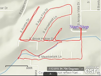
My GPS track shows that we hiked for 4 hours and 14 minutes and stopped along the way for 3 hours and 37 minutes, for a total time of 7 hours and 51 minutes. The total round trip hike distance was recorded as 6.9 miles with an elevation gain of 2012 feet and a highest elevation of 11,299 feet. Our GPS track is shown on the included map (below).


1Arizona Daily Sun, 4 September 2004

Wednesday, July 19, 2017

Ellis Health Update - 170719


On 3 July I Walked 2.5 miles at the recreation center and did 5 minutes at level 7 on a stationary bike. I then rescheduled Arizona Oncology appointments, canceling a scheduled chemotherapy treatment (now superseded by treatment at the Mesothelioma Treatment Center at Baylor).

The remainder of that day was spent on the telephone with the VA. I have submitted a claim with the VA and they wanted me to make an appointment to see a doctor at the VA Hospital in Prescott, AZ. The claim had been referred to Prescott from the Phoenix VA Hospital. Prescott wanted me to see their doctor on 8 August, a time when I will most likely still be in the hospital at Baylor recovering from surgery. I asked for an alternate date but was told that they were already booked up until 8 August and could not schedule more than 30 days in advance. I thought that was rather odd, as 8 August was already more than 30 days from the current date. I told them that was a catch 22 and asked them to send my record back to Phoenix. I then talked to a representative at Phoenix who agreed to put my file on hold until my current round of surgery is resolved.

As an aside, the way it was explained to me, the only reason I need to see a doctor at the VA is to do a breathing test, a test already performed during my present course of treatment. No wonder the VA is so far behind.

On the 4th, I again visited the recreation center where I walked 2.5 miles and did 10 minutes at level 7 on a stationary bike.

I met with our attorney on the 5th and then spent the next two days giving a legal deposition. That was the third and fourth day of a 4-day deposition.

On Saturday, 8 July, we traveled to Phoenix and then continued on to Houston on Sunday for surgery scheduled for the next day.

On Monday, 10 July, I underwent what is called Surgical Staging (surgical examination of the lymph nodes and intestinal area to determine whether the cancer has spread to those areas). After the operation, I was informed that there were no visible signs that the cancer had spread to these areas. This will be confirmed by biopsies taken during the procedure, results of which will be available next Monday or Tuesday. However, I was anesthetized for the procedure and a catheter was installed. The installation was very difficult due to an enlarged prostate and I am told it took three tries to insert it properly. This resulted in some damage that caused leaking (bleeding) around the catheter. As a result I was held for two days in the hospital before it was decided to remove the catheter and send me back home with a referral to my local doctor for followup.

We did make our already-scheduled flight back to Phoenix on Thursday, 13 July, but I was traveling in a wheelchair and not allowed to lift more than 10 pounds, actually I think they might have specified no more than 2 pounds for the first couple of days. Rosemary pushed me but I could tell that it was quite difficult by the way she grunted. If we return from the next surgery under the same conditions, I will insist that she wait for an attendant to push the wheelchair. In addition to being prohibited from lifting more than 10 pounds, I am currently unable to drive because of the medications I am taking.

I felt pretty drab for the next few days but finally managed a short walk in the neighborhood accompanied by Rosemary on the 17th and a one-mile walk by myself the next day.

Today, Wednesday, 19 July, I was notified that the “cervical mediastinoscopy and lymph node biopsies”, from the 10 July surgery were negative. Dr Sugarbaker still has to review my file and set a date for the major surgery, described as surgery to remove all cancerous cells that are visible to the naked eye. I am told that I will hear from the doctor no later than next Monday.

I celebrated the negative biopsy news by walking 2.7 miles at the recreation center. They have a short track; it takes 19 laps to do one mile, but you've gotta love the air-conditioning on these 100+ degree days.


Friday, July 7, 2017

Ellis Health Update - 170702


The last update was on 170613 following a 170606 office visit and after I had arranged a trip to Houston to consult with Dr Sugarbaker at the Mesothelioma Treatment Center at Baylor College of Medicine.

I underwent chemotherapy on 13 June (my birthday). Dr. Lindquist noted that it was my birthday and offered to shift the date. However, I told her that I would prefer to go ahead as scheduled.

The next day, 14 June, I felt good enough that I repeated and wrote an updated report for my 2.5-mile Neighborhood Walk. On 15 June, the second day after chemotherapy, still feeling good, I completed my 4.7-mile Big Block walk and wrote a report describing that walk.

The 16th of June was the third day after chemotherapy. This is a day that is normally totally lost because I feel so bad. Day four is usually a little better and then I am back to normal (or as normal as it gets while undergoing chemo) on day five. The doctor had prescribed sleeping medication for the three-day period surrounding chemo, the period when I take steroids, and I had hoped that the ability to sleep those three nights would alleviate the post-chemotherapy effects for days three and four. Alas, that was not to be.

I felt much better on 18 June; this was to be expected as it was day five after a chemotherapy session. The temperature outside was well over 100 degrees F, too hot to walk outside, so I decided to do a few indoor laps at the Recreation Center. According to a posted sign 19 laps equals one mile and, barring a miscount, that is what I did.

The next day I again visited the recreation center, this time carrying my GPS so I wouldn't have to count laps; I walked 2.5 miles this day and repeated that routine for the next two days.

On 22 June I underwent a PET Scan at the Verde Valley Medical Center. The scan was ordered by Dr. Lindquist at AZ Oncology where I have been undergoing chemotherapy. However, it would also substitute for the same procedure required at Baylor the next week. I just had to take a CD of the results with me to Houston.

The next day was taken up with collecting medical records to take with me to Baylor. Packed and organized for the trip to Houston. Dr Lindquist's Assistant, Victoria, called to tell me that the results of yesterday's PET Scan were good.

We traveled to Phoenix and stayed overnight at the Holiday Inn Express on 24 June and then took an American Airlines flight to Houston (George Bush International Airport) on 25 June.

The 26th of June was taken up with a series of tests at Baylor. These included the following: an ECHO (Echocardiogram), a Stress Test, an EKG (electrocardiogram), LABS (blood testing), a Chest MRI (Magnetic Resonance Imaging) and a PFT/6 Minute Walk (Pulmonary Function Test) and an Initial visit with clinic staff.

This was followed the next day by a group meeting. The purpose of this meeting was to introduce members of the treatment team. Among the individuals introduced were: Dr. Sugarbaker (Director, The Lung Institute), a Dietitian, a Social Worker, a Chaplain, a Patient Affairs Specialist and others. As explained, they are prepared to provide guidance on where to stay while undergoing treatment, how to navigate the scheduling system, what to eat in preparation for surgery and after surgery, transportation arrangements and, if all else fails, a chaplain to console the troubled soul.

After all the test results were available, including the PET Scan from VVMC, we met with Dr. Sugarbaker to discuss the findings and options. Dr. Sugarbaker tentatively scheduled me for Staging Treatment surgery or Surgical Staging* (surgical examination of the lymph nodes and intestinal area to determine whether the cancer has spread to those areas) on a specific date during the first part of July but also referred me to Dr. Diez for evaluation due to an anomaly noted during the stress test. I saw Dr. Diez that afternoon and was scheduled for a Cardiac Catheterization the next morning.

* Surgical Staging is described in a Mesothelomia Treatment Center handout as follows: "Three surgical sights may be explored as part of the staging of MPM (Malignant Pleural Mesothelomia). These are the thorax (chest), the anterior mediastinum (the space just anterior to the main airway) and the peritoneum (abdominal cavity). These spaces are explored using minimally invasive surgical techniques."

I underwent Cardiac Catheterization on 29 June and was cleared for the already-scheduled Staging Treatment surgery. Dr. Diez was very good, explaining the procedure very clearly in advance with drawings and in plain English. The other staff members were also friendly and efficient. However, the scheduling department at that hospital (CHI St Luke's) could use some attention. I arrived before 0715 and was rapidly checked in; I then remained in pre-op until after 1200. A 93-year-old gentleman, awaiting an operation to replace a heart valve, already in pre-op when I was wheeled in, was still waiting when I was wheeled out for my procedure.

On the 30th of June Rosemary and Julia checked out accommodations for future trips and decided that we should continue to use the Holiday Inn where we had stayed for this visit. This visit had worked out well, they provide shuttle service to and from the clinic as well as to other nearby locations, and they agreed to give us an additional discount if we returned for the major surgery, tentatively scheduled for a few weeks after the Staging Treatment surgery.

We traveled back home on 1 July, leaving Houston from nearby Hobby Airport at 0850 (a Southwest nonstop flight to Phoenix) and arrived back home before 1400. We switched to Southwest because they fly out of Hobby Airport which is closer to the medical center. They have several direct daily flights between Houston and Phoenix. This is important because, assuming everything goes well, I will need to make several followup visits to the clinic after the major surgery.

I am now scheduled to return to the clinic in early July for the Staging Treatment surgery mentioned above. This will tentatively be followed by major surgery a few weeks later to remove all of the cancer that, in Baylor Clinic terminology, "is visible to the naked eye." The plan is to then follow up with "chemotherapy and/or radiation therapy to kill any remaining cells."

This approach sometimes involves removal of a lung; however, Dr. Sugarbaker thinks, based on what he has seen so far, that he will be able to avoid that. If not, living with one lung is better than the alternative and I did meet a very lively and active patient who had one lung removed as part of his treatment. He was back at the clinic for a follow up visit.


Friday, June 30, 2017

TREKABOUT WALKING CLUB-July 2017


Walks are graded on a 1-4 scale (with 4 being the most difficult)
Meet Every Tuesday - hikes starting at 7:00am at trail head (subject to change)
HIKING SHOES RECOMMENDED/CARRY WATER/DOGS MUST BE ON LEASH
To join TrekAbout Walking Club, please email at jen.mabery@yavapai.us
Or call: 928-634-6877/928-301-6143
Get up and get moving! And it’s free

Tuesday July 4th!
Happy 4th of July!! Get out and do something!


Tuesday July 11th
Doe Mesa Trail” – This is about a 2.5 mile trail with a steep elevation gain. There are some very beautiful view rewards at the top!

Level 2.5(if your not used to the climb a 3)

Directions: From Cottonwood head to Sedona and turn left on Dry Creek Rd, Follow to the first T and turn left, follow to the second T and turn left. Go past the Fay canyon trail head and the next big parking lot on the left is Doe Mountain trail head.

Tuesday July 18th
Mingus Mountain” (Don’t know the real name) – I would say about 3-4 miles out and back. Go through some pines along the way to a very nice outlook view. Nothing too strenuous.

Level 2.5

Directions: From Cottonwood, Head up to Jerome, continue 4.2 miles beyond Jerome. You will then see a large pull out on the right that also has a big brown Prescott National Forest sign.


Tuesday July 25th
Cathedral Rock Summit” – This will only be about a 1.5 mile hike, but it has a very steap scramble to the top/center of Cathedral Rock. It is so awesome in the heart of the rock. Time to sit and stare or explore.

Level 2.5

Directions: It’s in the village of oak-creek, so coming from Cottonwood; head to Sedona via 89A then turn right onto HWY 179. Follow to Back O Beyond rd. and round-about to the right. Follow that until you get to the trail head.


Tuesday, June 20, 2017

The Big Block Walk - 170615


Several times during the past few weeks I have felt the urge to do a longer walk than the 2.5-mile jaunt around my immediate neighborhood. At first, in response to that urge, I ventured up Rio Mesa Trail to Quail Run and continued as far as I felt comfortable in going. Eventually, I substituted Desert Jewel and a small section of Contention for part of Quail Run because it is a more interesting route. Finally, rather than returning from my walk the same way I had gone, I continued to the south end of Quail Run, turned east on Quail Springs Ranch Road and followed it down the mountain to Old Hwy 279 (Camino Real) which I then followed north to Arrowhead Lane and then home. This route, 4.7 miles in length, is shown on the following map. I call it The Big Block Walk.

The Big Block Walk
As noted, I had walked this route several times before today, but always going counterclockwise. Today, having determined that the climb to Quail Run would be more gradual that way, I hiked it in the clockwise direction.

Leaving home, I followed Arroya Vista and Arrowhead to Old Hwy 279 (Camino Real) turned south and continued to Quail Springs Ranch Road. This was still a gravel road in the early 2000s when I first walked this way. I think the county must have paved it primarily as a dust abatement measure and I suppose it serves that purpose adequately. However, the road bed was not prepared properly before the asphalt was applied and much patching has been required since.

Much-patched Quail Springs Ranch Road
Just a short distance along Quail Springs Ranch Road I noted one of those ubiquitous road adoption signs which are used to announce organizations and individuals who have committed to keeping particular sections of road clean. This section appears to have been adopted by a public-minded tin lizard. He seems to have been doing a pretty decent job of it; there was very little debris scattered along the right of way.

The tin lizard who adopted a highway
The next noteworthy site along the walk is Quail Canyon, a gated community of 1.6- to 3-acre parcels. It boasts of “Electric Gas Water Paved, Curbed Roads.” Altogether, it appears to be an exclusive community of those who consider themselves a cut above the unwashed masses. To me that all added up to a group of people seeking to limit access to their community. However, when I paused for a closer look I noted something very odd about the physical arrangement of the main entrance to the complex. There are two separate gates, one for entry and another for exit. The entrance was unguarded and the entry gate stood wide open. It appears that anyone can enter but it is not evident that one can leave without a gate pass as the exit gate seems to be securely fastened.

Free to enter. But what about leaving?
Emblazoned on a sign near the entrance was a likeness of the bird for which the complex is named, Gamble's Quail (right). This bird is sometimes confused with the California Quail. As a matter of fact, I was told they were California Quails when we first moved to Arizona and only recently learned the difference. The example shown here is a male, distinguished by the copper-colored top feathers.

There are a number of side roads leading off Quail Springs Ranch Road, mostly just leading to one or a few homesites and ending. Some of these appear to be private drives while others seem to be maintained by the county. So far as I can determine a white sign with brown lettering indicates a privately-maintained road while a green sign with white lettering denotes a road that is maintained by the county.

However, some markings defy this neat logic. For instance Anica Lane is marked with a green and white sign on one side but sports an older sign on the other side proclaiming it to be a private drive and prohibiting trespassing or turning around. It could just be a left over sign from before the county adopted the road. Or it might be a small group of property owners struggling for exclusivity on the cheap. On the other hand, perhaps green on white really does not indicate that the road is maintained at taxpayer expense.

A mistake or struggling for exclusivity on the taxpayer's dime?
Continuing up the gently-sloping mountain I soon reached Quail Run and turned north. This is a road that I have walked often over the past fifteen years as a part of the Big Block Walk, at first as a break from report writing while I was still working.

A short distance from Quail Springs Ranch Road I found an unexpected patch of dodder (left). This is a parasitic plant that I was familiar with from growing up in East Tennessee. I tended to associate it with that sort of relatively high-humidity climate and was surprised to find it growing in such a dry spot and hosted by such sparse vegetation.

A little farther along, while crossing the wash below Pasture Well, I noted a sign (right) that warned passersby to “Beware of Dog,” the sort of sign that is more commonly posted on private property such as a fenced yard where a dog is kept. This looked more like an attempt to prevent people from walking up the wash on National Forest land. There are a couple of private homes located up that way and I am sure they have dogs. However, it they are left free to roam on the National Forest, an area open to the public, after the owner has already admitted by posting the sign that they are dangerous, I wonder about the legal consequences if someone were attacked. On the other hand, this is Arizona and reason doesn't always apply.

A short distance farther along Quail Run I crossed Christina Draw Wash, the same wash that runs by my house about a mile down the slope from here. This wash drains a large section of the eastern slope of Mingus Mountain south of Allen Spring and north of Black Canyon. Although normally dry this wash can become a raging torrent during monsoon season, overflowing its banks and damaging road crossings as it struggles to drain the water falling on the mountain slope above.

The short, not very difficult, climb out of Christina Draw Wash going north on Quail Run is the steepest part of The Big Block Walk when traversed in the clockwise direction. When traveling in the counterclockwise direction on the other hand the climb up the mountain on Desert Jewel (or on Rio Mesa, whichever is chosen) is much more difficult because elevation is gained more quickly.

On this day, refreshed by a cooling breeze which quickly evaporated the perspiration generated by my exertion on a 100+ degree day, I moved right along, soon turning east on Rio Mesa Trail. I made another right at Contention and then turned down the mountain on Desert Jewel. I usually choose this particular route because I just find it more interesting than Rio Mesa. For example, one house displays an eclectic gathering of artifacts grouped at a mailbox.

Eclectic collection of artifacts grouped at a mailbox
The purpose for the mailbox is obvious and I think the stove likely expresses the householder's opinion of junk mail. I have no idea what the cart with the half-barrel containers mounted on it represents. Nor do I know what the Indian (?) God or Goddess might represent.


I continued down the mountain to reconnect with Rio Mesa Trail at the end of Desert Jewel. Rio Mesa then took me to Camino Real which I followed to Arrowhead Lane, on to Arroya Vista and then home. As already noted the distance was 4.7 miles; the highest elevation was 3711 feet and the total ascent was 480 feet.

Friday, June 16, 2017

The Neighborhood Walk – Update 170614


The Neighborhood Walk is a 2.5-mile walk that grew from a 1.5 mile walk that I started doing around my neighborhood in Verde Village Seven when I commenced chemotherapy earlier this year. I then extended the walk to 2.3 miles by including another street and finally to 2.5 miles. The 2.5-mile walk is shown below.

Neighborhood Walk – 2.5 miles
A short section of the 2.5-mile walk is down the wash at the bottom of Christina Draw and, although the wash is open and affords easy passage, there is a short, steep descent to enter it at the end of Meadowlark Drive. Today, I decided that I would build at least a rudimentary trail for the descent. The dirt was loose and easy to dig with a shovel-shaped rock I found nearby and there were plenty of other rocks to use for shoring up the lower side of a narrow scooped-out trail. After about 15 minutes of effort I would up with what I consider a much-improved descent into the wash.

Improved descent into Christina Draw Wash
The official monsoon season starts tomorrow and I am hoping the rains arrive soon afterward. That should help to consolidate the work I did today and show me where I need to make improvements.

For the most part this walk has already been described and photographed in a previous report:

In this report I will just point out a few new sights and some seasonal seasonal changes I have noted during the time I have been traveling this was. For instance, today I met a friendly rabbit (right) who hesitated long enough for a photograph before he decided I was probably a predator out looking for lunch and scampered off into the brush.

Since the last report on this walk I had stopped at my friend Angel's house to have my photograph taken with him and to collect a photograph of Angel in uniform during the Korean War.

Ellis Price and Angel Vargas – 26 May 2017
Angel Vargas during the Korean War
Having already spent several minutes constructing my trail into the wash, I did not stop today at Angles house (or museum as I call it) to chat and admire his collection of antiques from his old homeplace, the Alvarez Ranch at Sycamore Canyon. These can be seen, along with other items collected during his career in the National Guard and while working as a munitions expert in the already cited report:
As I continued on down the wash, I was alert for other wildlife; in addition to the pervasive quails and frequent lizards, I have seen at least one jackrabbit, albeit a little further down the wash between Arroya Vista Drive and Old Hwy 279 while on another walk. I was much too slow with my camera to photograph it; however, I did find a good photograph1 (left) on Wikimedia Commons.

Leaving the wash and heading west on Brook Hollow Drive, I paused to photograph a century plant (right) I had been patiently watching for several days as it slowly came into full blossom, gradually turning yellow .from the bottom up. Finally, on this 14th day of June, it was in full bloom, framed by matching Mexican bird of paradise shrubs and shown against the background of Mingus Mountain.

Continuing west on Brook Hollow Drive, I turned north onto Acoma Drive, a short street that runs downhill and ends just 0.2 miles ahead at a wash . I walk down and back on it because because it adds 0.4 miles to my walk and presents a nice, invigoration climb on the way back.

Just a short distance along Acoma Drive, a very short street called Acoma Circle leads to the west. This is actually more a driveway than a real street as it just leads to a single, vacant, hillside lot, still for sale. I checked it out several times waiting for some large sunflowers to bloom, finally with success.

Sunflowers blooming on a vacant lot at the end of Acoma Circle
After walking to the end of Acoma and returning to Brook Hollow, I turned north on Agua Fria Drive. Along the way, tucked under a sugar sumac shrub and protected from the hot afternoon sun, I found a vibrant, sacred datura (left) in full bloom.

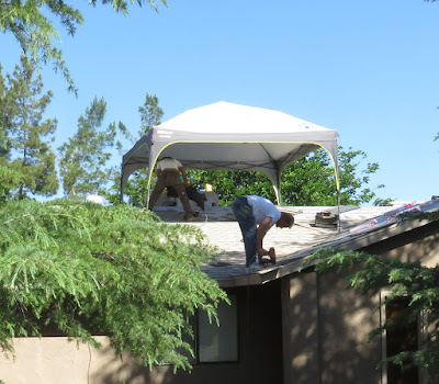
At least three of the houses along the way have been re-roofed since I began doing this walk. In one instance the roofer had come up with a rather ingenious method of shielding himself from the sun. He had erected the sort of portable canopy one often sees at campsites. The roofer said it cost him about $150 at WalMart.

Roofer protected from the sun by a portable canopy
Still on Agua Fria Drive, there is a vacant, overgrown hillside lot for sale that supports all sorts of indigenous plants. The most striking among these for now is a gorgeous cactus (right).

Agua Fria Drive ends at Del Mar Drive and the homeowner on the corner of those two streets has a motley collection of three very noisy dogs. One is a medium-sized mutt and the other two are small, extremely shrill yappers. They all seem to think it is their duty to alert the entire neighborhood every time someone walks past in the street. I finally resorted to carrying a dog whistle and stopping dead in the street and blasting their ears with all my might until they stopped barking. The larger dog soon got the idea and shut up. The smaller ones took a while longer. But I can now walk past with a minimum of barking; a couple of blasts from my whistle usually does the job.

After reaching Del Mar Drive I turn back on S Arrowhead Lane, return to Brook Hollow and follow it to Arroya Vista Drive and then home. But because that does not quite make a 2.5-mile walk, I take a short detour up and back on Elk Circle. Elk Circle is a pleasant street with attractive homes. However, glaring in its contrast with the otherwise pristine surroundings, is an old abandoned car. I noted it when I first started walking this way, primarily because a piece of side molding had come loose at one end on the driver's side door and was hanging down to the street. Sometime later the attachment at the front end of the molding strip had also given way and I kicked it under the car where it is at least less visible. Meanwhile, the derelict vehicle continues its steady deterioration. Today I noted that the left front tire is flat. It will soon be time for cinder blocks or a tow truck.

Its about time for cinder blocks or, hopefully, a tow truck.
Back on Brook Hollow Drive, I cross Christina Draw Wash once to reach Arroya Vista Drive and then again in the remaining short distance home. There I am greeted by a gorgeous bank of yellow lantana. We planted the lantana in an iris bed several years ago and found that it takes over and begins blooming each year just about the time the irises are done and continues until frost. We remove the dead foliage each fall and wait for the cycle to begin again with the return of the irises in the spring. We eventually planted another bed of lantana, red this time, for a bit of contrast.

Yellow lantana in the foreground; red lantana and Texas sage in the background
This is not a very long or very strenuous walk; however, in the heat of summer, I am always ready for a quick nap when I get home.


1Jessie Eastland (https://commons.wikimedia.org/wiki/File:Big_Ears_Sitting.jpg), https://creativecommons.org/licenses/by-sa/4.0/legalcode

Tuesday, June 13, 2017

Ellis Health Update - 170613

Background

I am undergoing treatment for Stage 4 Mesothelioma Lung Cancer. The problem started with chest pains on 2 January 2017 after I returned from my workout at the gym. A trip to the emergency room resulted in a CT (computed tomography) scan that revealed a mass in my right lung. A later biopsy indicated it was mesothelioma; a sample was sent to the Mayo Clinic for a second opinion; Mayo concurred in that diagnosis and I was sent for a PET (positron emission tomography) scan at the Verde Valley Medical Center clinic in Sedona, the nearest facility with a PET machine. Following the PET scan I was referred to the Arizona Oncology Center Sedona facility in the same building. I saw Dr Anthony at the oncology center who discussed treatment options and recommended chemotherapy consisting of the following two drugs: Pemetrexed and Carboplatin, treatment which I am now undergoing.

Previous posts touch on this subject are shown at:
and
and

Current Status

On 6 June we went to Sedona and saw Dr Lindquist (Dr Anthony has accepted a research position at an institute in California) for a scheduled chemotherapy visit; however my platelet count was too low and she rescheduled it for next Tuesday, 13 June (my 85th birthday; she noted that and offered another date but I declined because I like the Tuesday schedule). She also changed me from a three-week schedule to a 4-week schedule and scheduled a PET Scan for 22 June. Dr Lindquist prescribed temazepam to help me sleep while taking dexamethasone (steroid) tablets for the three-day period surrounding each chemo treatment. It seems to work as I slept for almost 8 hours the 0n 12 June, the night before today's chemotherapy session. I usually have a couple of down days following chemo. Perhaps some of that has been caused by sleeplessness.

Additionally, she referred me “to Dr David Sugarbaker at Baylor College of Medicine for an opinion on surgery for mesothelioma.” I fly to Houston on 25 June and expect to return home on 1 July. At my advanced age, I am an unlikely candidate for surgery, but if there is a chance that surgery could be performed, possibly resulting in remission, I am willing to consider it. After all, the chemo treatment I am now undergoing is only intended to keep the cancer under control, possibly prolonging my life for another couple of years and I suspect that my quality of life would deteriorate significantly over that time.

Meanwhile I am still holding up quite well. I did my usual 2.5-mile walk yesterday and would have aimed for the 4.7 mile “big block” walk today had not the chemo treatment interfered. I will see how I feel tomorrow and perhaps go for a walk after Julia leaves for the airport. She has been a very welcome and most helpful visitor for the past ten days.

Both she and Diana will meet us in Houston for the evaluation with Dr Sugarbaker's team. Hopefully, Julia's husband, Rick, will also be able to come. I have not seen him for some time.
My next update will likely be sometime in early July