Wednesday, March 22, 2017

Weatherford Trail


Buoyed by a sunny forecast, five of us gathered at the Safeway parking lot in Cottonwood at 0500 on 16 July 2011 for a hike on Weatherford Trail. We drove to Flagstaff and stopped at Denny’s for breakfast. After breakfast we continued on into Flagstaff, took US-180 W and followed it about 3.2 miles before turning right on Schultz Pass Road. We followed Schultz Pass Road about 5.3 miles to the trailhead parking lot at Schultz Tank. The turnoff to the parking lot is on the right (south) side of the road. We arrived at the trailhead at about 0740. A toilet is provided at the parking lot.

Donning our gear we found a sign (right) on the north side of the lot marking the Weatherford Trailhead. The trail started out at a gentle slope that varied very little all the way to our destination at Doyle Saddle. NOTE: A very short distance up the trail from the parking lot we crossed an old road. On the north side of this road, a sign says Weatherford Trail while on the south side it is signed as Schultz Trail. Go figure.

About 2 miles (by GPS; 2.4 according to signage) from the parking lot the Kachina Trail leads in from the left. We continued on up the mountain on Weatherford, and shortly entered the Peaks Wilderness area.

We paused along the way for an occasional rest break and after a couple of hours for a snack break and a group photograph (below). We had a long way to go and so didn’t linger for very long. The trail continued its gentle slope along the old road that, according to the forest service, originally carried passengers to the peaks via Model T Fords. Higher up the trail became pretty rocky. Gordon described it as walking on egg-sized marbles. It is really not too bad as long as you step carefully, and it does maintain the same gentle slope all the way.

Left to right: Donna Goodman, Gordon Bice, Dolly Yapp and Betty Wolters
Gordon and I had hiked on ahead a short distance and waited for the rest of the group to catch up. I took the below photograph as the rest of the group were arriving.

Left to right: Betty Wolters, Dolly Yapp and Donna Goodman at rest stop
We had, according to my GPS, come 5.8 miles from the trailhead. Hearing this, Dolly and Betty, declared that as they had only signed up for an eleven mile round trip hike, this was enough, and they would stop to eat lunch start back.

Our hoped for destination was Doyle Saddle where we would be able to look down into the Inner Basin and up to Humphrey's Peak. So, leaving Dolly and Betty eating lunch, Gordon, Donna and I pressed on, hiking another 1.9 miles according to the GPS before reaching Doyle Saddle. By the time we arrived it was 1220; we were tired and ready to eat. We could see Humphrey's Peak ahead and Dona and Gordon were able to pick out where they had been on a hike on Abineau Trail earlier this year. The inner basin was below us but we really couldn’t see much of it from the saddle. We ate lunch, I took a nap and shot a few photographs and we headed back.

From Doyle Saddle - Humphreys Peak (against the sky at upper left)
From Doyle Saddle – Looking back toward Flagstaff. Weatherford
Trail is seen to the left in this photo
We didn’t note what time we left Doyle Saddle; however since I did manage to get in a nap and we spent a bit of time enjoying the view we must have spent most of an hour there. I will estimate that we started back down about 1315.

The far-off views all along Weatherford Trail were spectacular now that we were facing down the mountain and we were torn between looking far away and watching our step on the loose, round pebbly surface of the old tourist road the trail follows.

We stopped often just to look without the bother of switching our view to look where we were stepping. The below photograph, with a view of Flagstaff and beyond from just below Doyle Saddle, was taken during one of these stops.

View looking out over Flagstaff – Taken from Weatherford Trail just
below Doyle Saddle
We arrived back at the trailhead at 1645 to find Betty and Dolly waiting for us. According to the sign at the trailhead, the distance to Doyle Saddle is 6 miles and our round trip hike would have been 12 miles. However, the one-way distance as measured by my GPS was 7.8 miles, making it 15.6 miles round trip. I don’t know which measurement is more accurate; however, my feet were telling me to go with the GPS reading. The highest elevation was 10877 feet and the total ascent was 3138 feet.

The GPS elevation readings were 8047 feet at the trailhead and 10877 at Doyle Saddle, an elevation difference of 8030 feet.

Our track is shown on the included map (below).


Red Rock Park to Gooseneck Bend


On 12 March 2011, fourteen Skyliners traveled north from Cottonwood on 89A and turned on Lower Red Rock Loop Road. We drove the entrance to Red Rock State Park, turned and parked alongside the road at the Lime Kiln Trailhead across from the park entrance. George and Akemi had traveled from Sedona and were waiting for us there. The below plaque is mounted at the trailhead.

Plaque mounted at Lime Kiln Trailhead at Red Rock State Park
From the trailhead Lime Kiln Trail first runs to the southeast parallel to Lower Red Rock Loop Road for about 0.1 miles, crossing a wash along the way, and then turns sharply up the slope of Scheurman Mountain. The trail climbs around 400 feet in 0.9 miles to cross a lower ridge on the south slope of Scheurman Mountain and then descends to cross Lower Red Rock Loop Road heading generally west. About 1.0 mile from Red Rock Loop Road, where Lime Kiln Trail follows a dirt road, we came to a fork in the road. At this point, we took the left fork, leaving Lime Kiln Trail. This fork is marked as 9845H, although the marker is a metal stake, partly hidden in the bushes and cannot be read until you pass it and look back. After following Road 9845H for about 0.1 miles from Lime Kiln Trail, we came to Horse Trail A. This trail actually crosses the road at this point; to continue toward Oak Creek at Gooseneck (sometimes called Horseshoe) Bend we turned left onto the horse trail. A metal stake bearing the letter A identifies the trail.

About 0.25 miles from 9845H, Horse Trail A enters an old road. We continued along this road going uphill to arrive at a saddle in the ridge overlooking Oak Creek above Gooseneck Bend. At the saddle in the ridge, we left the old road and continued on the horse trail going downhill to the southeast toward Oak Creek. About 0.25 miles from the saddle in the ridge and just above Oak Creek, the Indian ruins were visible in the cliff across a wash to our right. At this point, we could either (1) turn off the trail to the right and find a place to cross the wash and climb the hill to the cliff or (2) continue down the horse trail to a fence, apparently designed to keep stock from entering Oak Creek, and follow that up the hill to the cliff. We chose the second option.

Note the rock wall built under the overhang. This could be either 
Indian Ruins or a latter day fake?
At the bottom of the hill, part of the group made the steep climb up the hill along the fence to reach the ruins. The rest of the group continued straight ahead and found a nice lunch spot at the foot of a cliff alongside Oak Creek. We all ate lunch, some at the ruins, some alongside the creek, before heading back

After eating my lunch at the ruins, I made my way directly down the steep slope toward the creek rather than follow the fence back. I then walked up a dry wash alongside the creek to join the rest of the group before starting back. Along the way I found the below pictured log fabricated by some industrious beaver. Following lunch we all gathered for a group picture before heading back.

Left over building material from a beaver construction project
Left to right: The author, Daisy Williams, Dolly Yapp, Name Withheld, Miriam 

Sterling, Marvin Alt, Jim Manning, Unable to contact, Donna Goodman, 
Connie Woolard, Bill Woolard, Akemi Tomioka, Jan PreFontaine, George 
Everman, Lila Wright and Fran Lind – photo by George with time delay
The photograph below shows Oak Creek at the apex of Gooseneck Bend where most of the group stopped for lunch.

Apex of Gooseneck Bend in Oak Creek – photo by George
According to my GPS file, we hiked 6.6 miles. The elevation change was around 530 feet. Those who retraced the entire hike route on the return trip ascended a total about 1050 feet. For those who returned part of the way by hiking along Lower Red Rock Loop Road, and thus did not climb back across the foothill of Scheurman Mountain, the total ascent was around 750 feet.

Our GPS track is displayed on the included map (below).


Friday, March 3, 2017

The Neighborhood Walk


As most of you know, I was recently diagnosed as having lung cancer (mesothelioma, stage 4).

After my second session of chemotherapy, I was feeling well enough that I decided to incorporate a walk around the neighborhood in my daily schedule. I walk the same 1.5-mile route each day, starting at the mailbox on the street in front of our house and heading south on S Arroya Vista Drive.

The walk takes me past Mescal Drive, the street that fronts our property on the south, across Christina Draw, past Brook Hollow Drive and to the south end of S Arroya Vista at the top of the hill. There the street turns right (west), becoming Meadowlark Drive. The view from our house to the end of S Arroya Vista Drive is shown here (below).

Looking from our mailbox across Christina Draw and on to the end 
of S Arroya Vista Drive at the top of the hill.
Although it is not immediately obvious from the above photograph, a substantial wash runs down Christina Draw and under S Arroya Vista Drive. The wash is normally dry; however, it drains a large section of the eastern slope of Mingus Mountain south of Allen Spring and north of Black Canyon. Heavy heavy rains on the mountain above can turn it into a raging monster of a stream. The below photograph was taken in March 2007.

Christina Draw Wash in March 2007
The distance to the turn onto Meadowlark Drive is 0.2 miles. Meadowlark Drive then leads along a level ridge for a short distance before descending to end at Christina Draw Wash, about 0.4 miles upstream from the S Arroya Vista Drive crossing. The view while walking west on Meadowlark extends to the top of Mingus Mountain.

View looking west on Meadowlark Drive – Mingus Mountain on the horizon
Just 0.3 miles from Arroya Vista Drive Meadowlark comes to an abrupt end (right) at the wash.

There, I was faced with a dilemma. If I turned back here, my walk will be only about a mile long. And all of that would be on paved surfaces. I really wanted to walk a bit farther and wanted to include some distance along a rougher surface to give my ankles a workout. Nothing is more irritating to me than a sprained ankle.

After examining the wash and determining it to be open and relatively easy hiking, I decided to give it a try.

Christina Draw Wash from the end of Meadowlark Drive
The wash turned out to be the most interesting part of the walk. It is open and free of large boulders all the way from Meadowlark to Brook Hollow Drive, a distance of 0.3 miles. Below Brook Hollow it tends to close in a bit with overhanging growth and a less open path. Since it is rattlesnake season and I would be traveling alone, I decided to avoid the section between Brook Hollow Drive and Arroya Vista Drive, leaving the wash at Brook Hollow.

The wash , except perhaps for changes in stream flow caused by the construction of houses in recent years, remains in its natural state with the exception of some erosion prevention measures along a single property.

Rock wall built for erosion protection along Christina Draw Wash
On my way past that property, I found the owner out working in his back yard and stopped to chat. Angel Vargas, a widower, has lived there and battled the wash for some thirty years. Angel served in the Navajo Army during the Korean War and in the National Guard; he retired from the Navajo Army Depot in Bellemont in the 1980s.

The stone wall seen above roughly corresponds with the location of the bank when he moved in. His battle continues as he reinforces the bank with various materials salvaged from a variety of sources, including discarded WWII practice bombs (left) from the Army depot where he worked.

In the photograph below a line of these old practice bombs can be seen serving as the base of a section of retaining wall.


Practice bombs serving as the foundation for a section of Angel's retaining 
wall
Angel's accumulation of treasures rescued over the years include an old 6-cylinder engine and a horse-drawn turning plow, both once used on the Alvarez Ranch in Sycamore Canyon where Angel grew up.

Old 6-cylinder engine
Old horse-drawn turning plow
The engine could have been used to drive a water pump for irrigation. The owner of a small portable sawmill where I once worked as a teenager used an engine very much like this one to power his mill. AS for the old turning plow, I spent many youthful hours following behind one of those pulled by a team of mules.

Another memory from long ago was brought to mind by an old horse-drawn scoop. I used one of these when I was about 14 years old to clean out a pond on our farm.

A horse-drawn scoop
I really do not look back on the days Angel's collection of equipment called to mind with a lot of longing. I never learned to actually enjoy such work. At the time, I thought it was just because I was rather lazy. However, in retrospect, I think that I just wasn't interested. The best thing I can say is that such hard labor led me to join the Navy.

Angel's front yard, in contrast to the collection of artifacts in the back yard, is quite neat and orderly.

Angel's front yard
High on the bluff just across the wash from Angel's home is a large house (right) that is presently for sale and he is making an effort to, in his words, “clean up my back yard” so as to present a better view to prospective buyers. In my opinion almost everything he has collected has long since entered the status of “artifact” and can by no means be called junk. I call the place Angel's Museum; I certainly hope that he doesn't go too far in his clean-up efforts.

My feelings about “junk” may be influenced by memories of my Grandpaw Wicker's junk yard. Grandpaw was a farmer, a carpenter and a sawmill operator who also owned a thresher that he used during wheat and oat harvesting season to thresh grain for other farmers, collecting a toll for the service.

He bought all of his equipment second hand and repaired and maintained it himself. He seemed always to have a tractor, a truck or some other piece of equipment under repair. When something was simply beyond its useful life, it was never completely discarded but was instead moved to a location under a large oak tree that was called the “junk pile.” There it would reside just in case some part of it became useful for repairing some other piece of machinery. As a result I have always thought of old machinery as stuff that might be useful someday.

From the wash at Angels Museum, the bridge where Brook Hollow Drive crosses the wash is clearly visible. Our house can also be seen beyond the bridge.

Brook Hollow Bridge across Christina Draw Wash 
– Price home visible in the distance
The bridge marks 0.8 miles of my 1.5-mile walk. If I turned right (east) on Brook Hollow at the bridge, another 0.2 miles would bring me back home. However, still wanting more than a one mile walk, I turn left (west) and walk to the end of the street.

Heading west on Brook Hollow Drive
At the end of Brook Hollow Drive, I pause for a view across a wash (unnamed) and the houses along Quail Run to Mingus Mountain.

View to Mingus from the end of Brook Hollow Drive
I then retrace my steps for about 100 yards and turn left (northeast) on Agua Fria Drive.

Looking northeast on Agua Fria Drive
Agua Fria Drive is 0.3 miles long, running from Brook Hollow Drive to Del Mar Drive. Del Mar Drive then runs for 0.1 miles from Agua Fria Drive to Mescal Drive. From the junction of Del Mar and Mescal, it is just another 50 yards to the Mescal Drive side of our house.

Our house seen from Mescal Drive
The total walk as shown on the map (below) is 1.5 miles long; the highest elevation is 3560 feet and the total ascent is 266 feet.

The Neighborhood Walk
Eventually I decided to extend my walk and found that by turning right on Acoma Drive when I reached the end of Brook Hollow Drive and continuing to the end of that street and returning, I could extend the hike distance to an even two miles. Then, a little additional experimentation disclosed that by taking S Arrowhead Ln from Del Mar back to Brook Hollow and then proceeding to S Arroya Vista and back home I could extend the walk to 2.3 miles. This is shown below.

2.3-mile walk route

Friday, February 24, 2017

Camp Verde Cliff Dwellings


On 4 February 2017 thirteen Skyliners (Jim Manning, Jim Gibson, Mark Purcell, Karl Sink, Glen Sperry, Ellen McGinnis, Jim McGinnis, Joanne Hennings, Joyce Arregui, Theresa [last name unknown], Daisy Williams, Anita Jackson, and Frank Lombardo) drove through Camp Verde on Hwy 260 and parked on the left side of the road at mile marker 225.4. The trail leaves the road through a permanently closed gate of heavy pipe. There is room at this location to park 5 or 6 cars. This parking area is arrived at before reaching Clear Creek. It is necessary to pass through the closed gate by climbing between two widely spaced pipes.

Even though, we were really close to highway traffic we found that bushes nearby were adequate cover for a restroom stop before starting out on the trail. Caves up high on a cliff are visible from the beginning of this well-traveled but unnamed trail. This hike includes both cliff dwellings and other (pithouse) ruins. Fifteen Skyliners had hiked here on 12 February 2011. A few of today's hikers had been on that previous hike.

In 2011 I had been the last hiker to finish the climb up to the caves, the last few hundred feet of which is very steep, requiring some hard climbing to reach the first of the cave dwellings. The others that day had already left the cave area when I arrived and I only had time to take a couple of photos before hurrying to follow them. So I was really glad that this time our leader, Jim Manning, gave us about twenty minutes to explore all the caves that I had bypassed before.

This Photograph (right) shows stone and mortar partial enclosure of a cliff dwelling and includes hikers Theresa and Anita.

Just below the cliff dwelling shown here I saw and photographed two substantial pottery fragments (below left). We found many other potsherds scattered in various locations at this site. In keeping with the custom for such locations, we just examined and photographed them and left them in place for others to enjoy. A second cave with stone and mortar enclosure is shown here (below right).

Pottery shards below dwellings                    Dwelling with a mortared opening
Below Anita Jackson and Karl Sink are shown still exploring a cave while Glen Sperry and Jim McGinnis are departing.

Anita, Karl, Glen and Jim exploring a cliff dwelling
From the cave area we made our way on up to the top of the mesa where we found a deep, narrow chasm (left) separating two unequal parts of the mesa. The smaller part of the mesa where we went next was covered with ruins. The ruins were circles of low rock walls like the ruins of pit houses. To reach them we had to climb up over some larger rocks on the way up. A good example of these ruins is seen in the photograph below which shows Ellen McGinnis sharing a particularly impressive pottery shard with Frank Lombardo while Jim McGinnis quenches his thirst.

Ellen, Jim and Frank standing in the ruins atop the mesa
Ellen placed the pottery shard back atop the rock where she found it (below right). Note that the fragment, shown below, has a part of the rim still attached and a piece of corncob is located nearby.

Looking back on the caves
 in the wall of the mesa
Looking back from the ruins atop the mesa, we could see the caves below (left) along which we had followed the trail on the way up.

Leaving the smaller part of the mesa where the Indian ruins were located, we crossed the chasm that separates the two parts and hiked uphill through an area of creosote bushes (right) toward the high point of the mesa. Creosote resin was used by Native Americans as a glue; other parts of the plants were used medicinally.

When we arrived at the top we were looking down on the Salt River Materials Group Clarkdale Cement Plant's Gypsum Mine. Gypsum is used as a cement retarder so that the cement dries more slower.

Gypsum Mine
As seen below, from the high point of the mesa we had a clear view all the way to the San Francisco Peaks.

Looking north to the San Francisco Peaks
Rather than returning by the trail we had followed past the caves to the top of the mesa, we split into several groups that descended by different routes, creating a real problem for our hike leader. Along the way we passed some tall tree-sized Canotia holacantha plants (right). This species is the most common of the crucifixion-thorns.

Along the way down the wall of the mesa there was a very old stump with many roots (left) with only a few of those roots still attached to the soil. This stump probably could be dislodged very easily. I held my camera pointing downwards above the stump to get a photo of the star-like arrangement of the roots.
In his report1 of the 2011 hike in this area Ellis Price described two peaks located below the mesa alongside Hwy 260, “two small peaks visible from the mesa; one shows vegetation and one is completely bare. I saw no indication of anything, such as a rock layer, that would have caused the peaks to form naturally, and there was no sign of a road that might have been used by heavy equipment. I have no idea what produced them.” He also provided the following photograph.

Two small peaks at the foot of the mesa alongside Hwy 260
Curious to see whether I could determine the origin of the peaks from an up-close examination, I chose what appeared to be the easiest route to them. I had thought that others in our group would have felt the same curiosity and that I would meet them there.

However, I found myself alone at the peaks. The only evidence of other human activity was a few old footprints. As already noted we had started the descent in several different groups; now the individual groups had splintered, some making their loop shorter by going across the face of the mesa to intersect the trail that we had ascended on and some making a longer loop by heading more directly towards the highway and then returning to the trailhead.

I became concerned about being out of sight of everyone else while examining the peaks. However I finally caught sight of Jim Manning and waved to him. Jim waved back, indicating that he saw me, so I lingered to take the following photographs. One of the peak with sparse plant growth (below left) and one of the bare peak (below right).

Sparsely-covered peak                                              Bare peak                                             
As I approached the sparsely-covered peak I first thought that maybe it could have been a huge dump of useless product left over from the Gypsum Mine operations. But, if that were true, where was the road used by the dump trucks? The second smaller bare peak seemed to me to resemble somewhat the mudstone formations that I had seen years before in an area of the Grand Staircase Escalante National Monument. A closer look at photos of both peaks gives a hint that if all the white pebbly soil which covers the peak with vegetation were removed then that peak might look much the same as the bare peak. And all the white pebbly soil below the base of the bare peak looks as though it has eroded down off of the peak.

The geology of the Verde Valley is historically such that it sometimes held lake water interspersed with periods when it completely dried up leaving evaporites of salt and gypsum near the present town of Camp Verde. During wet periods the lake was quite extensive. High lake water left deposits of white limestone while low lake water left deposits of brown mudstone.

On leaving the peaks I was out of sight of the others for a long time because I could not find any other safe way down from those peaks than by retracing the route that I had taken in order to get there.

I finally caught sight of a few of the other hikers. I had made it down from the peaks and found a place where I could cross to the other side of a gulch which separated me from them. Jim McGinnis had backtracked looking for me. When I reached where Jim Manning was he let me know that he had been concerned about what could have happened to me.

After following along Hwy 260 to rejoin the other hikers, already back with the vehicles, Jim Manning reminded us that we should all try harder to remain together as a group, keeping at least some of the other hikers in sight at all times.

Editor's note: No one made a GPS track of this hike, a major shortcoming in my opinion, so I have used the track I made during the 2011 hike. The route at least approximates the route taken by the author of this report. The red track on the included map shows the route to the top of the mesa; the blue track shows the 2011 return route.

This report was written by Daisy Williams and assembled, edited and posted online by Ellis Price with help from Lila Wright.


1Price, E. F. (2012). Hiking in and around Verde Valley. United States: Createspace. P 327


Monday, February 13, 2017

Dogie Trail – Sycamore Pass


Parking at Sycamore Pass
Location: 34°55'21.08"N; 111°59'41.80"W
Elevation: 4681

Thirteen Skyliners (Donna Goodman, Betty Wolters, Daisy Williams, Anita Jackson, Dolly Yapp, Miriam Sterling, Marvin Alt, Gordon Bice, Fran Lind, Lila Walker, Ellis Price and two others) hiked on Dogie Trail in the Sycamore Canyon Wilderness on 10 April 2010. On 28 January 2017, Jim Manning led a second group of hikers (Karl Sink, Glenn Sperry, Jon Beach, Jim Manning, Chris Jensen, Jim Gibson, Dana Smith and Dave Beach). From Cottonwood, both groups took State Highway 89A to FR 525 just past mile marker 364. Then followed FR 525 for about 2.8 miles before turning left on FR 525C (Sycamore Pass Road) and continuing for about 9 miles to arrive at the Dogie Trailhead at Sycamore Pass.

Our hike leader for the 2010 hike, apparently still aggravated from our failure to remain closely grouped on a previous hike, lectured us severely about Skyliner Rules. Most importantly, we were told not to get ahead of the leader and to remain together so that she would know where everyone was at all times. She also said that we were supposed to be a social group and that we were to remain together and enjoy socializing as a group. Altogether, it reminded me of being chewed out by Chief Petty Officer Weir, my Company Commander during recruit training in 1951.

On the 2016 hike, one member, had a problem with his legs part-way into the hike and had to turn back; Dave Beach remained with him while the rest of the group continued on to Sycamore Creek. I had noted in 2010 that a couple of signs, with the trail name misspelled as “Doggie” instead of “Dogie,” were posted at the parking area and along the way to where the trail officially starts. No one mentioned the signs on this hike and I don't know whether they have been corrected. In any case hikers pass through a gate at the saddle about 200 yards from the parking area and enter the Sycamore Canyon Wilderness through a gate. Dogie Trail starts at this point.

After passing through the gate in April 2010 , I paused to take a couple of photographs looking ahead into the wilderness.

Looking into Sycamore Creek Wilderness from the saddle
Looking into Sycamore Creek wilderness from the saddle
On leaving the saddle the trail, at first, leads fairly steeply downhill. The following photograph shows the trail as it appeared in April 2010.

Heading down into the wilderness from the saddle on Dogie Trail  - 2010
For the current hike it was covered with ice, as shown in the below photograph, provided by Jim Manning.

Treacherous, ice-covered trail in February 2017
Probably the most distinctive rock formation along the trail is shown below. I thought it looked a bit like a giant coffee mug.

Rock formation resembling a giant coffee mug
We saw numerous flowers along the way in 2010.

Creamcups                                                    Dwarf mountain ragwort (?)
Purple milkvetch                                           Touristplant or Draba
Plains blackfoot/Blackfoot Daisy             Dock of some sort
Just under 1.75 miles from the parking lot we passed Sycamore Tank. The tank contained very little water in 2010. But, as we noted on the way back in on that hike, enough to attract a couple of migrating ducks. Sadly, my attempt to photograph the ducks resulted in nothing useful. However, Jim photographed the now-brimming tank, alas without ducks, during the current hike.

Sycamore Tank in January 2017
After traveling just over 5.5 miles from the parking lot we reached Sycamore Creek. From here the trail crosses the creek and continues upstream along the opposite side to connect with the Taylor Cabin Trail about one-half mile ahead. We stopped in 2010 and again in 2017 at the stream for lunch before turning back. In 2010, I ate rapidly, had a quick hot tea and settled in for a nap. I managed to find a nice spot several yards from the group and the quiet murmuring of the creek soon lulled me to sleep. I awakened about forty-five minutes later when the other hikers were up and ready to head back up the trail. I lingered a bit to take a photograph.

Looking up Sycamore Creek from the Dogie Trail Crossing in 2010
The hikers report that Sycamore Creek was running full, bank to bank, at the time of the 2017 hike.  Unfortunately, no one thought to take a photograph. 

The total hiking distance was 11.3 miles as shown by my GPS in 2010. This distance was recorded from the parking lot to Sycamore Creek and back. So far as I can determine, no GPS track was recorded for the current hike. The GPS profile for the hike shows a maximum elevation of 4881 feet and a minimum of 4194 feet. The elevation change on Dogie Trail between the parking area and Sycamore Creek is only 687 feet; however, the total in-and-out ascent, due to all the ridges and washes crossed along the way, was recorded as 2251 feet. It is not a difficult hike, but does require some stamina.

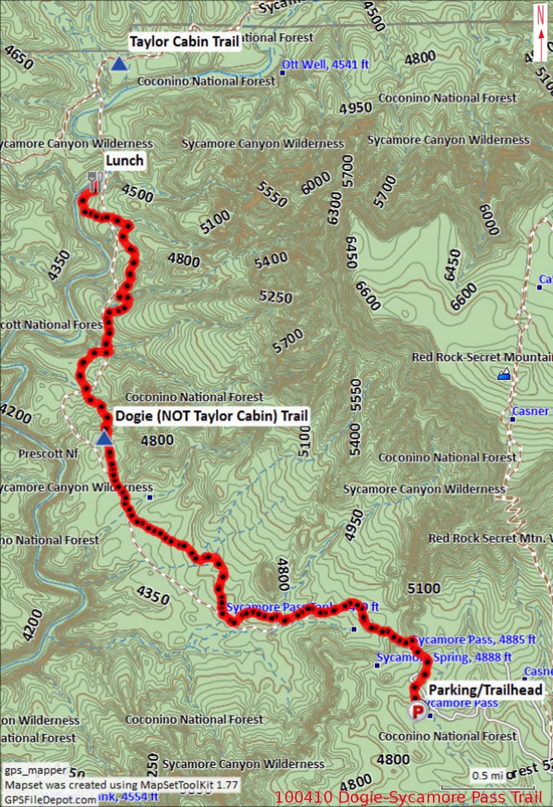
The map included as part of this report (below) shows the GPS track recorded in 2010 for this hike.

NOTE: On some maps, Dogie Trail is incorrectly listed as part of Taylor Cabin Trail.