Tuesday, November 1, 2016

Hike to AMBRR Tunnel


I had long had a hike to the Arizona Mineral Belt Railroad (AMBRR) Tunnel on my list of things to do. I had scheduled it four separate times and been forced to cancel because of weather conditions or other circumstances. Finally, Gordon Bice, Karl Sink and I set out on 28 October 2016 determined to finally cross it off the list.

We left Cottonwood at about 0800, drove east on Hwy 260 to Hwy 87 on the Mogollon Rim, turned north on Hwy 87 and continued to Rim Road (Forest Road 300). We turned right onto FR 300, continued along the rim to the General Springs area and parked. The Arizona Trail (below left) crosses FR 300 here on its way north, having followed Colonel Devin Trail #290 (below right) up the mountain from Washington Park, 2.5 miles below the rim.

Cropped from Arizona Trail Sign Colonel Devin Trail sign
The Battle of Big Dry Wash historical marker is located across the road from the Colonel Devin Trailhead. It is inscribed as follows.

Seven miles north of this point a band of Apache Indians were defeated by United States troops on July 17, 1882. A group of tribesmen from the San Carlos Reservation had attacked some ranches in the vicinity, killing several settlers. Cavalry and Indian scouts were immediately sent into the field in search of the hostiles. Five troops of cavalry and one troop of Indian scouts converged on the Apaches, surrounding them at the Big Dry Wash. The resistance of the Indians was broken after four hours of stubborn fighting. The casualties numbered two soldiers and more than twenty Apaches.

Off hand, seven miles from the site of the battle being memorialized seems an odd place to erect a monument. However, the depredations of the Indians seem to have covered a fairly widespread area. For instance, according to Wikipedia Commons, the cabin shown below, built in 1880 and now located at the Pioneer Living History Museum in Phoenix, was among those raided by the Indians. The cabins original location at Canyon Creek in Young, Arizona, is just about on a straight line between the San Carlos Reservation and Big Dry Wash1.

Marine 69-71, Phoenix-Pioneer Living History Museum-Flying V Cabin-1880-2, CC BY-SA 4.0
But back to the hike at hand. The odd lettering, “RR Tunnel TR. NR. 390.15 Mi” on the Colonel Devin Trailhead sign (shown previously) turned out to be a rather awkward way of saying that the Tunnel Trailhead was located 0.15 miles ahead. We decided the person who lettered the sign probably ran out of room and just shoved the numbers together. In any case, Railroad Tunnel Trail (my AMBRR Tunnel Trail) was located a short distance ahead. It turns off to the left just beyond the powerline pole, number 66, shown below. Karl Sink is shown below, standing on the AMBRR Tunnel Trail just after the turnoff. Colonel Devin Trail, meanwhile, continues down the right side of the wash.

Hiker Karl Sink heading down the trail
A sign (right), located at the head of the trail, was a bit confusing; we had expected to hike in and back on the same trail and we did not understand what “loop” might mean. Assuming that the answer would become obvious later in the hike we put the question aside and continued on our way.

My GPS recorded the distance from the Colonel Devin Trailhead at FR 300 to the AMBRR Tunnel Trail Loop turnoff as 0.1 miles, this as opposed to the 0.15 given on the trailhead sign at FR 300. But, in any case, the exact distance is not needed to locate the turnoff, powerline pole number 66 serves as an excellent marker.

The trail itself is quite clear once one turns off the Devin Trail. It follows along what was obviously built as a wagon road, perhaps once used, among other purposes, to transport equipment to the tunnel construction site. Whatever its original purpose, considerable effort had been devoted to building the road. In some places the canyon wall had been carved away (below left) to make space for the road; in other spots a retainer wall had been built to contain the roadbed. Gordon is shown standing on the trail at one such point (below right).

Roadbed carved from the canyon wall Gordon on trail atop retaining wall
About 0.4 miles from the start of AMBRR Trail, and 0.5 miles from FR 300, we came to a fork in the road. The photograph (left) shows the trail by which we had descended on the right; the left branch would obviously descend to Colonel Devin Trail at a different point, and a lower elevation, than where we had left it.

From the fork, the trail left the old road and led east-northeast up a steep, rocky side canyon; the way is marked by a single-word sign (right) affixed to a dead, charred section of tree trunk, felled no doubt by the 1990 Dude fire. The trail from the fork to the tunnel is steep and rocky; it wanders in and out of the streambed at the bottom before ending in a steep climb to the mouth of the tunnel. The distance was only around 0.1 miles; however it rises about 300 feet in that distance and the steep, rocky climb made it seem like twice that.

We came upon the tunnel suddenly, just at the top of a short, especially-steep section of trail that may have been ascending a tailings pile below the opening. The dark tunnel opening looms to the left in the below photograph; seen at right is the wall of a stone hut that might have been used to house workers. The walls are about six feet high and it appears that the hut once had a wooden roof, perhaps peaked to allow standing upright.

Mouth of AMBRR Tunnel and section of rock-walled hut – photo by Karl Sink.

Just across the canyon from the tunnel opening stood a long-dead ponderosa pine whose trunk had been burned almost through just above ground level (left). So little remained of the trunk that I thought the tree should have collapsed at the slightest of breezes.

I had started out on this hike thinking that the tunnel would lead southeast from its opening. However, we found that from this opening it lead very near directly north, perhaps veering a little easterly. That means that had it continued for its planned 3100 feet, it would have come out somewhere in General Springs Canyon. Meanwhile, the never-laid track leading to the south end of tunnel, where we stood, would have climbed along the steep canyon walls seen at left in the below photograph.

Canyon wall along which the railroad would have climbed to the tunnel
It certainly cannot be denied that this was an ambitious project. According to various sources, the Arizona Mineral Belt Railroad was conceived in the early 1880s as a means of shipping ore from the mines to the Atlantic and Pacific Railroad in Flagstaff. Timber companies around Flagstaff would also use the line to ship shoring timbers to the mines. Part of the route would run through this 3100-foot tunnel under the Mogollon Rim. Unfortunately, the company ran out of money after digging only a short section of the tunnel.

Most sources give the completed length of the tunnel as 70 feet. However, that is misleading in that it apparently represents only the part of the tunnel that was excavated to its full intended dimensions. A lesser bore continues into the mountain for about another 80 feet; apparently this section is not normally considered when measuring the length of penetration because it is not fully excavated. One can, however, walk to the very end, about 150 feet from the opening.

These two photographs show the small-bore extension, that is the section of tunnel beyond seventy feet (below left) and the tunnel opening (below right) as seen from about the end of the fully-excavated section.

The end of the tunnel              Looking out the tunnel
                                                    opening
A number of visitors to the tunnel have, over the years, felt impelled to record their presence and the easily-accessible parts of the main tunnel walls are largely covered with graffiti. The most noticeable bit of graffiti was perhaps a red hand print (below left). Some of the markings, bearing signatures and dates, seemed almost to constitute confessions to vandalism (below right).

Mark of a red-handed            Is this a confession?
vandal 
The canyon wall (perhaps cliff would be a more accurate term) above the tunnel looked extremely daunting, but we thought we could see a route that might take us to the top, so we gave it a try.

Canyon wall above the tunnel
We wound up climbing about 200 feet above the tunnel before deciding that it was just too dangerous. We had invested over half an hour in the effort by the time we arrived back at the tunnel opening. We, or at least I, had a few sore muscles the next day.

After a short pause to catch our breath, we set out back down the side canyon, following the path we had come in on. On arriving back at the fork in the trail, we decided that rather than return to the rim the way we had come, we would take the other fork and find out for sure where it would take us. As for the old road the trail had followed from Colonel Devin Trail near the rim to the fork, it continued straight ahead, not following the course of either of the trail forks. Later reference to the USGS online map, disclosed that it was probably the original road from Washington Park to the Rim at General Springs.

We did not further investigate the course the old road but set out on the trail fork we had chosen, arriving about ten minutes later at a junction with Colonel Devin Trail. The loop hike concept now became clear. The loop, described from the way we hiked it, started at the upper connection with Colonel Devin Trail, continued along the ancient roadbed to the trail fork, turned up the side canyon to the tunnel, returned to the fork by the same route, took the other fork back to Colonel Devin Trail and hiked up the canyon for about 0.4 miles, climbing some 415 feet to close the loop.

As we labored our way up the trail along the west side of the, dry at this point, East Verde River, I remembered a little more of the history of the area. According to Stan Brown, in an online article published by Payson Roundup, the trail we were on was named for “Army commander ... Thomas Devin” who built a “switchback trail” that “leads down the east side of the river”2. That description accords well with the old road we had followed down the canyon to the trail fork. The Colonel Devin Trail, in contrast, runs on the west side of the river.
The East Verde starts at the rim at the head of the canyon and flows down past Washington Park to join with the Verde River in the Mazatzal Wilderness, about 35 miles away.

As noted in a description of the river by the Verde River Basin Partnership, the river is dependent on rainfall, snowmelt, and supplementation from the Blue Ridge Reservoir”. A brief history of the the Blue Ridge (Now C C. Cragin) Reservoir, is available on the Salt River Project website.3

According to my GPS track the actual loop hike, starting and ending at the upper Colonel Devin/Tunnel Loop junction, measured 1.4 miles The highest elevation was shown as 7280 feet and the total ascent as 821 feet. Including the abortive attempt to climb the cliff above the tunnel, a side trip to investigate the area above the tunnel between FR 300 and the edge of the cliff and some other minor side trips, we actually hiked 3.1 miles and ascended 1163 feet, again according to my GPS.

On the attached map (below), the green track shows Colonel Devin Trail from the trailhead at Forest Road 300 to the junction with Tunnel Loop Trail. The red track shows the Tunnel Loop (or as I have called it AMBRR Loop) from its upper junction with the Colonel Devin Trail to the trail fork below the tunnel, up to the tunnel, back down the mountain to the fork, on to the lower junction with Colonel Devin Trail and then back along that trail to the upper junction.


1https://commons.wikimedia.org/wiki/File:Phoenix-Pioneer_Living_History_Museum-Flying_V_Cabin-1880-2.jpg
2http://www.paysonroundup.com/news/2003/aug/25/stories_from_the/

3http://www.srpnet.com/water/dams/cragin.aspx

Saturday, October 29, 2016

Barbershop Trail Hike


On October 29, 2016, nine Skyliners started out from our usual car- pooling point at the Cottonwood Safeway parking lot. The tenth hiker met us on FR 300. The ten hikers were as shown below:

Left to right: Jim McGinnis, Karl Sink, Jim Gibson, Chris Jensen, Lila Wright, Daisy Williams, Ellen McGinnis, Frank Lombardo, Betty Wolters and Dave Beach – photograph by Ellen McGinnis
We had reached FR 300 (also known as Rim Road) by going 2.5 miles on Highway 87 after taking Highway 260 to its intersection with Highway 87. We traveled east on the Rim Road for 17 miles to Forest Road 139 to leave one vehicle at the end of the hike. The remaining vehicles continued on to FR 137 for the beginning of the hike. Before reaching FR137 everyone in the lead vehicle got treated to the sight of a black bear running across the road directly in front of our vehicle. The bear was about 4 to 5 feet long, maybe 3 feet high at the shoulder and must have weighed around 200 pounds. This bear was really traveling fast and no one had a chance to capture a photo; nevertheless,everyone's spirits were lifted by the bear sighting. What were the chances of having something like this happen?

This bear was actually brown, but black bears can be light brown, blonde, or reddish brown as well as the more usual black. This information, along with the fact that they can run at speeds up to 25 miles per hour, was taken from the "Critters of Arizona Pocket Guide1." Barbershop Trail #91 is a part of the Cabin Loop Trail System. That trail system was the subject of an Arizona Highways magazine Hike of the Month in the August issue in 1993 written by William Hafford. Cabin Loop Trail links three cabins: General Springs Cabin, Pinchot Cabin., and Buck Springs Cabin.

According to Hafford, these cabins were built by the Forest Service during the early 1900s and have been used as fire-guard stations. Hafford also stated that these three cabins and the ragged east-west line of the Rim enclose a rough circle with a diameter of about eight miles. A part of Barbershop Trail goes across FR 137and downhill to Buck Springs Cabin. We began our hike by looking at Buck Springs Cabin. There is an information sign beside the trail above the cabin. sign, shown in the photograph below, explains that there are two cabins here at Buck Springs Fire Guard Station.

Sign posted at Buck Springs Fire Guard tower
Both the older cabin (below left) and the larger, newer cabin (below right) are shown here.

                             Cabin built in 1923                  Cabin built in 1946

We climbed back up to FR 137, crossed the road and continued on the trail down the slope of Buck Springs Ridge on the other side where several switchbacks led us into Yeager Canyon. On this hike there are many canyons and drainages to go down into. For this report, I used a description of the hike by Bruce Grubbs.2 Grubbs says that the trail crosses several roads, generally on the broad ridgetops, where it is important to follow the blazed route carefully. And he says that where the trail follows other roads for short distances you need to follow the blazes carefully. One tree had a sign for Cabin Loop Trail (below left). Much further along the trail I took a photo of a tree blaze that was different than the other blazes that I had seen (below right).

                              Cabin Loop Trail sign              A different blaze

Early on in our hike we came to a tricky crossing where there was some water. (below left) This must have been in Yeager Canyon because it came before we reached a sign which said that we were .5 mile from Buck Springs Cabin and that the junction with Houston Brothers Trail was still 4 miles away (below right).
A tricky spot                                Trail sign                            
Also before reaching that sign I had taken a photo of a tree scorched by lightening but still partly green and we wondered if it could possibly survive. (below left). Before long we came to the first of several unusual trees that we were to see on this hike. This tree had three trunks. (below right).

Lightening-damaged tree       Tree with three trunks       
And shortly thereafter we saw a tree with two trunks that had trapped the branches of a tree of another type of tree between those two trunks (right). Or had this other tree wrapped its branches around the taller two-trunked tree?

We came next to a meadow (below left) which might be the same meadow in Ellis's scouting report that he described as a “long, narrow meadow formed by a wash leading north into Bill McClintock Draw.3 After leaving the meadow we came to another unusual tree, one that I would describe as a double-decker Christmas tree. There were other trees in an area close to this one which had similar narrowing of the mid-sections; however, they did not look like two Christmas trees stacked one above the other as in the following photo (below right). Lila gave the explanation that these narrowed mid-sections were often caused by elk using those trees to rub the velvet off of their antlers.

Long narrow meadow            Stacked Christmas trees    
It was obvious that elk were in the area of this hike because in many places along the trail, actually right in the trail, there were elk droppings. Some were quite fresh looking.

We ate lunch at the location of the tree that had been shattered into many pieces by a lightening strike (left). This view of that tree looks very much like the photo in Ellis's scouting report which he had taken of this same tree.

I had taken several shots trying to get more of the widely scattered pieces of that tree into my photos. While eating their lunches the hikers sat on various pieces of that shattered tree.

When I had finished my lunch I noticed a blackened area (right) on the other end of the piece that I had been sitting on while eating. If this image is magnified then little shiny specks within the black area can be seen beneath the bent splinter of wood. Maybe they are crystallized bits of tree sap?

After lunch and after passing by the sign in Dane Canyon and going even further along Barbershop Trail I took another photo that is very much like a photo in Ellis's scouting report (below left). Ellis labeled his photo, "view looking north down Barbershop Canyon". I took another photo that gives a closer view of the big rock in the photo just mentioned. In the closer view there are trees near the rock that are now leafless which must have had beautiful Fall colored leaves not long ago (below right).

                         Looking down Barbershop       Large rock in Barbershop                           
                         Canyon                                         Canyon
 Almost to FR 139 we passed through a gateway of metal poles on either side of the trail. At the road we waited a short time while 2 hikers went on a few hundred yards to the official end of the Barbershop trail in order to have it on the GPS. Then we all loaded into our vehicle, some of us riding in the pickup bed so that no one had to walk the 1.9 miles back to the Rim Road where Jim and Ellen had left their vehicle.

The drivers continued on back to the beginning of the trail to retrieve the remaining vehicles while the rest waited at the intersection. While Karl, Betty, Jim Gibson, Frank and myself waited we had time to venture out to the edge of the Mogollon Rim to take in the view down off the rim and out to the way beyond (left).

Also take a look at the photo of Karl looking out from the rim (right).

None of us who saw that bear run out in front of Dave's van before we began the hike will ever forget that sometimes life gives us some really surprising views.

The hike is shown in red on the attached map (below).

According to the cleaned-up track recorded by the Skyliner GPS, the Barbershop Trail is 5.2 miles in length. The raw GPS track for the hike gave a reading of 7.1 miles. Approximately 0.8 miles of this difference is because the hikers parked on forest roads apart from the trailheads at each end. The remainder is due to GPS error and side trips from the trail. The highest elevation was shown as 7707 feet and the total ascent as 1097 feet.

Report author: Daisy Williams
edited by Lila Wright
modified for online use by Ellis Price


1McCarthy, Ann E., David A. Frederick, and Jonathan Norberg. Critters of Arizona Pocket Guide. Cambridge, MN: Adventure Publications, 2002.
2Grubbs, B. Hiking Northern Arizona: A Guide to Northern Arizona's Greatest Hiking Adventures, 2nd edition, pps 266-267. Guilford, Conn,: Falcon, 2001.

3http://ellisfprice.blogspot.com/2016/09/barbershop-trail.html

Friday, October 28, 2016

Kelsey-Dorsey-Hog Hill Loop

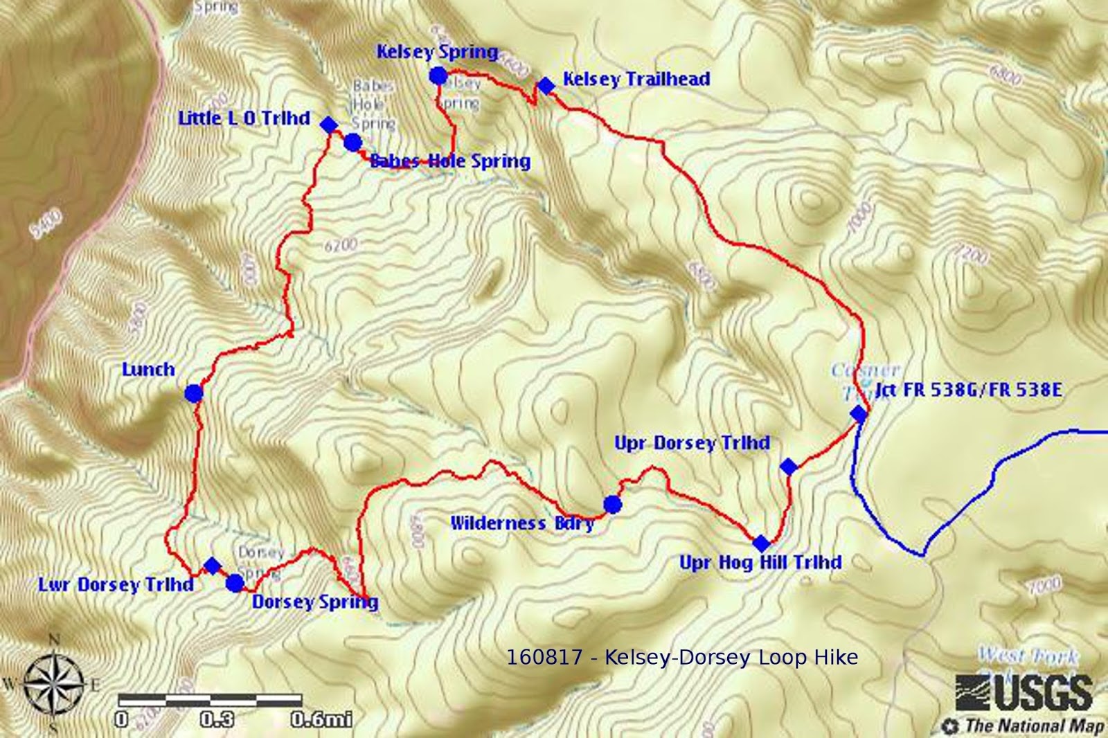
This is a quick memo to record a 15 October hike in Upper Sycamore Canyon. As shown on the below map, the hike utilized part of Forest Road 538G, part of Kelsey Trail, all of Dorsey Trail and a very short section of Hog Hill Trail.

A more complete description of the trail, based on a 17 August 2016 scouting hike, is available online at:

GPS track of the Kelsey-Dorsey-Hog Hill Loop – recorded by Ellis Price on 160817
The trail map included above is taken from the report of that August scouting hike.

On the current hike, participants reporting seeing wild turkeys and deer; on the scouting hike we saw no wildlife other than a few birds and perhaps a ground squirrel or two.

Ellen McGinnis provided several photographs taken with her smartphone during the recent hike; most of these duplicated, or were very similar to, photographs included in the referenced scouting hike and I have included in this report only a group photograph of the hikers at the Dorsey Spring Trailhead and one looking across Sycamore Canyon.

Left to right: Mark Purcell, Gary Jacobson, Jim Gibson, Ellen McGinnis, Daisy Williams and Karl Sink –hike leader Dave Beach is not shown
The photograph taken looking across Sycamore Canyon was an excellent shot of a view along a ledge of loose rocks running through an opening in the forest and showing the craggy cliffs on the other side of the canyon. It includes a dead tree standing alone at the edge of the forest and low-lying undergrowth with fall colors backed by the green of the coniferous forest along the edges of the forest opening.

Looking across Sycamore Canyon to the craggy cliffs on the other side
This report was compiled by Ellis Price with assistance from Lila Wright and input from Ellen McGinnis.


1http://ellisfprice.blogspot.com/2016_08_01_archive.html

Wednesday, October 19, 2016

Picture Canyon and Old Caves Crater


On October 8, 2016, eight Skyliners traveled north on I17 to Flagstaff, then east on I40, and north on 89A, stopping at Eldon Pueblo ruins which has a parking lot on the left side of the highway. From there, we hiked north a few hundred feet to the Arizona Trail. Turning east on the trail, we entered a large drainage bridge under 89A and continued southeast on the Arizona Trail. The trail meanders through the quiet forest and we were soon at the lower end of Picture Canyon Natural and Cultural Preserve. The city of Flagstaff acquired 478 acres in 2012 and are in the process of establishing trails in the area.

We took a group photo next to the wetlands in the Rio de Flag drainage (photo 1). The nearby Wildcat Hill Wastewater Treatment Plant provides a year long source of water for the wetlands which are protected by a fence surrounding the channel of water The fence extends downstream to the end of the Preserve and up stream to rough, rocky cliffs.

Photo 1 - Jim McGinnis, Karl Sink, Casey Hughes, Donna Goodman, Ellen McGinnis, Daisy Williams, Loren Pritzel, Lila Wright
We hiked upstream just outside of the western side of the fence to the rocky area. We continued a short distance in the rocky area to a point where we could see a series of waterfalls. From that viewpoint we ate our snack (photo 2).

photo 2 - Waterfall in Picture Canyon
Following social trails up through the rocks to the top, we immediately came to a sunken area with rock walls on the sides. There were many shards of pottery on the trail coming up out of the canyon. The Northern Sinagua people lived in this area.

Returning downstream to the intersection of the Arizona Trail crossing the wetlands, we walked a few hundred feet further downstream to a large area of petroglyphs on an outcropping of boulders. Two examples of these are shown below (photos 3 & 4). The Preserve had established a path up into the rocks for close up photos. They have erected frames for future signs that will probably give the viewer more information about the people who made the petroglyphs but at this point the frames are empty.


A group of 5 llamas with packs and their owners were traveling along the Arizona Trail and as they crossed the small bridge in the wetlands, the second llama slipped and sat down with one leg hanging off the side of the bridge. It sat very still while its owner pulled and pushed its leg for a couple of minutes. Finally it got its leg up and hurried off the bridge. The third llama refused to cross and was taken to the back of the group. The next two crossed and, possibly not wanting to be left behind, the rebel llama hurried across. They definitely provided our entertainment for the day (photo 5).

Photo 5
We retraced our steps on the Arizona Trail to our vehicles and Jim gave us a mileage of 6.5.

Getting back in our vehicles, we drove north on 89A for 2.4 miles, turned right on Silver Saddle Road and proceeded 1 mile to the trailhead for Old Caves Crater on the left. It was around 1 pm and we were hungry so we walked at short distance into the forest and ate our lunch as soon as we found a nice log to sit on.

We ate a quick lunch as the clouds were getting heavier and we hurried on up a wonderful trail. There were several choices of trails as the trailhead map shows (photo 6. at end of report). We took the direct route to the top where the small caves are. As the map indicated, the round trip distance is 2.2 miles so that gave us a total hiking distance for the day of 8.7 miles.

The vista from the top showed us how many houses are on all sides of the crater. We could also look directly west to Mt. Eldon and the San Francisco Peaks. We heard distant thunder as we hiked up the trail and now at the top there was a close strike on Mt. Eldon so we quickly made our way down the trail to the vehicles. There were no more lightning strikes near or far and a light sprinkle started just as we got in sight of the vehicles.

Thanks to Ellen and Karl for wonderful photos.

Photo 6 – Old Caves Trails System
Report by Lila Wright

Woody Mountain Lookout and Flagstaff Arboretum


On
October l, 2016 the Skyliners had a delightful surprise hike.  Seven
of us drove north
on I-17 to Exit 337 turned back over the freeway, right on Hwy 89A
and, after half a mile, turned left on Purple Sage Road. (At least we
would have if the hike leader had not been confused about going into
Fort Tuthill).  After 1.8 miles on Purple sage (NF 532), we turned
left on NF 231 (Woody Mt. Rd.). We were looking for NF 231 C when we
got to Roger's Lake, but it is unmarked now. We stopped at a new
parking lot at the south end of Roger's Lake and read a sign with a
map (below)
that showed new trails in the area.

Posted trail map
The trail we chose was called Gold Digger. We saw on the map that it would intersect the road that goes to the top of Woody Mt. As the trail led us gently upward in a meandering fashion, we soon heard a bull elk bugle. He treated us to two more calls when Gary Jacobson answered his challenge. But we never caught sight of him or any other elk. We did sight five fleeing deer on the hike and two mule deer near the road going in.

Looking to the north, the hikers could see the cloud shrouded Lowell Observatory and the San Francisco Peaks (below).

San Francisco Peaks and Lowell Observatory
We ate a late snack when we came to the intersection with the Woody Mt. Road and then quickly proceeded up the road to the lookout on top. We were a little concerned about clouds growing darker. At the look out, we discovered it was open but unoccupied. As it had cleared up somewhat, we had sunshine and a clear view in a full circle. When we made this hike six years ago the lake showed water; but it looked dry this year.

Rogers Lake from Woody Mountain
After lunch we took our group photo (below) at the Woody Mountain Lookout, with Jim McGinnis' camera which he was able to set on a timer and join the group.

Left to right: Beverly Sass, Gary Jacobson, Daisy Williams, Karl Sink, Ellen McGinnis, Jim McGinnis and Lila Wright.
Coming back down the mountain to the intersection of the Gold Digger trail: we continued on with the trail. Just a few hundred feet down the trail off a ridge we had been on, we came to a brand new ramada, picnic table and large water storage tank (below left). Next to it is a beautiful stand of young and old aspen (below right) protected by an elk fence.


Karl chose to go along the Two Spot trail which travels in a straight line along an old rail line at the edge of the lake. The rest of us followed the upper portion of Two Spot trail which was away from traffic noise and which meandered greatly in and out of gentle: shallow canyons. Karl arrived at the parking lot at one hour before the meandering group.


Each trail intersection is well marked as shown by the photograph displayed here (right).

Lila was attempting to use the Garmin GPS but was unsuccessful in figuring out the mileage. Thankfully Jim was able to get a mileage of 8.2. Our intended hike would have been 4 miles: so we doubled that but thoroughly enjoyed the beautiful trail.

With a little research the author discovered that in November of 2010 Coconino County acquired 22,250 acres of land in and around Rogers Lake. Go to Rogers Lake County Natural Area for further information. Skyliners last hiked the Woody Mountain area in 2010, the same year the county acquired the land and had no idea what changes were coming.

At the end of our hike, we climbed back into our vehicles and retraced our route on NF231 to the Arboretum which we had driven past earlier in the morning. Only four hikers went in. Two drove on to their destination in Flagstaff and one rested in the vehicle. Inside: we headed for the butterfly house first and were rewarded with three different species of butterflies in a wonderful habitat. A posted sign (left) informed us that butterflies smell With their antennae, and taste with their feet! The butterfly season is nearly over and of course many more species can be seen during the summer months. We saw the monarch (below left) and zebra longwing (below right) along another one that was not photographed or identified. The staff was very helpful in answering our questions.


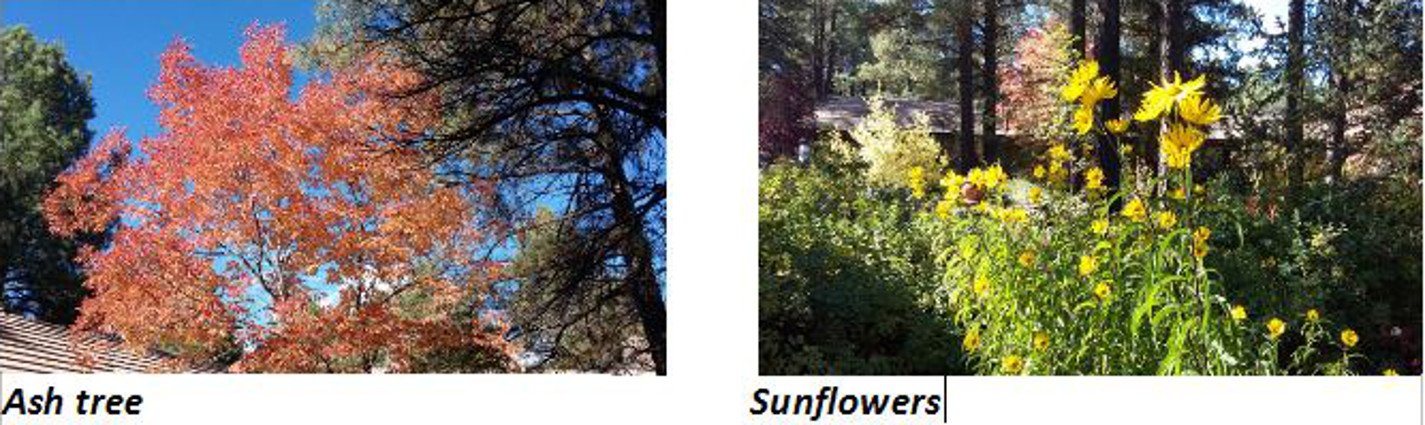
The grounds of the Arboretum were awash in autumn colors. The white ash (below left) was brilliant orange and the Maximilian sunflower (below right) was radiant yellow Apart from our group, we did not see another hiker all day and were amazed we had the whole place to ourselves. We will have to keep abreast of the county building more trails in this area in the future. It is definitely an area that offers much.


Report by Lila Wright