Monday, October 12, 2015

Kehl Spring to Forest Road 144 on Crook Trail

It was a bright, sunny day on 10 October 2015 when we started out to hike the section of General Crook Trail that lies between Forest road 144 and Kehl Spring. This was supposed to be a relatively easy 10-mile hike. I had downloaded a track that we could use in our GPS that would take us from Kehl Spring to Twentynine-Mile Tank, located about 0.6 miles northwest of Twentynine-Mile Butte; although our track measured 10.3 miles, we going to a spot on Forest Road 144 (note previously FR 149) about 0.3 miles short of the tank. Unbeknownst to me, the downloaded track ended about 1.2 miles southeast of the butte. This left us another 2.1 miles to travel along Crook Trail to reach FR 144 where we had parked our pickup car at a wide camping area. This increased the length of the hike to 12.4 miles. Additionally, we lost the trail after reaching the end of our downloaded track and hiked an extra mile or so, making the total hike about 13.5 miles.

As to the actual mechanics of the hike, we left Cottonwood at 0700, drove east on Hwy 260 and turned left onto Forest Road 144 just short of mile marker 249. Crook Trail crosses the forest road 0.4 miles from Hwy 260 at a large open camping area. There were nine of us and we were riding in three cars. So we parked one vehicle here and continued in the other two to Kehl Spring to start our hike.

The distance from where we left the pickup car on FR 144 to the start of our hike at Kehl Spring was 13 miles. To get there, we drove back to Hwy 260, continued east to Hwy 87 and turned north, turned right on Forest Road 300 (Rim Road) and continued for 7 miles to Kehl Spring where we parked at the campground. Kehl Spring Campground, Located, at the edge of a small meadow in a ponderosa forest, has eight campsites with fire rings. A vaulted toilet is provided but there is no running water. All Terrain Vehicle use is not allowed other than to enter or leave the campground; however the campground is located adjacent to Rim Road which can become noisy and quite dusty in dry weather. The primary season is March through September, but the facility is always open, weather permitting.

We found a place to park that would avoid interfering with campers and would permit easy retrieval of the vehicles later. In other words we parked them end-to-end along the outer perimeter in a manner that would prevent anyone from blocking us in without also obstructing the road into the campsite.

No signs were posted at the campground showing the location of Crook Trail, so we just hiked east through the meadow in which Kehl Spring is located, following along an old wash that we thought must have marked the old wagon road. Sure enough, that assumption turned out to be a correct, as we found two of the ubiquitous aluminum chevrons used as markers along this trail posted on adjacent trees just across the road at the upper end of the meadow. We passed between the trail markers and were certainly now following the old road traveled by Army supply wagons trekking between Fort Whipple and fort Apache in the 1870s.

The trail, marked along the way by the aluminum chevrons (occasionally painted a copper color) followed closely along, sometimes contiguous with, the present day Rim Road. An example of both colors of chevron are shown in the photograph below.

Copper and aluminum chevrons posted together along Crook Trail

While still following the section of trail, shown in the above photograph, that is contiguous with the road we stopped for a group photograph along the grassy bank.

Left to right: The author, Karl Sink,Ellen McGinnis, Jim McGinnis, Floyd Gardner, Daisy Williams, Dave Beach and Karen Webster – photograph by name withheld
The trail soon left Rim Road and we were back in the deep forest, guided only be the faint imprint of the ancient Crook Wagon Road and the shiny chevron markers. There were more of the copper-colored ones located along this stretch of trail than I remembered seeing on previous sections of the trail. We examined one of them more closely and found that they were merely the standard aluminum chevrons with a coat of copper-colored paint applied. I have often wondered just why one would go to the trouble of painting perfectly serviceable aluminum trail markings and then distributing them seemingly at random along the trail. Perhaps they were left over from another job.
In sections of old growth trees, we could follow the course of the trail just by observing where trees were missing in other places a distinct roadbed was visible.

Still visible section of the old General Crook Wagon Road

We found the following sign posted at one place where the trail just touched Rim Road without crossing or entering it.

General Crook Trail sign along Rim Road

Some old forest roads, used long after the demise of the old wagon road, followed it in places and it is easy to follow the trail along those sections. However, it is also easy to miss the point where the old trail and a newer forest road diverges. The hiker must pay constant attention for chevrons or other signs indicating these road/trail separations. That later happened to us just before we reached the end of our downloaded track and was the cause of an extra mile of hiking while we rambled around in the forest looking for the trail.

When we reached Hwy 87, the trail turned south and followed closely along the east side of the highway toward the junction with Hwy 260. At first it ran several hundred yards away from the highway, but then it crossed through the perimeter fence and continued south along the highway right of way. Here we found still a third color of chevron marker, bright red. Someone suggested that this section of the trail might be so marked to indicate that it is used by snowmobiles.

General Crook Trail following alongside Hwy 87 – note the red chevron

The trail crosses to the west side of Hwy 87 at Corduroy Wash about 0.6 miles north of the Hwy 260 junction. It then continues west parallel to Hwy 260, never more than about 0.6 miles away. Our downloaded track ended at the farthest point away from the highway, but still some 2.1 miles short of our hike's end at FR 144.

When we neared the end of the hike, the three drivers went ahead to retrieve the cars from Kehl Spring. The rest of us hiked at a more leisurely pace to the end of the trail and waited for them. It was now growing dark and, despite having donned my jacket, I was a little chilly. Fortunately, a kind group of nearby campers invited us to join them at their campfire. I leaped at the opportunity and was soon warming myself at a cozy campfire. The others then filtered over one at a time until we were all gathered around the fire.

By the time the drivers returned to pick us up it was almost 1900 and I didn't get home until around 1945.

The actual hike from Kehl Spring to Forest Road 144 (still shown on some maps as FR 149) is 12.4 miles as shown by the red track on the map included in this report. Note that I have corrected the track to remove the extra distance that we hiked. The very faint yellow track near the upper left shows the 0.4 mile drive along FR 144 to the Crook Trail Crossing. and the fainter blue track, intertwined with the red one, shows the downloaded GPS track that we were following.

The actual hike distance for this trail is 12.4 miles, the maximum elevation is 7926 feet and the descent was 1442 feet and the ascent was 1010 feet.


Wednesday, October 7, 2015

HS Canyon from Long Canyon Road


As our first hike for the 2015/2016 season, ten Skyliners hiked HS Canyon on 3 October 2015. We parked on Long Canyon Road at the Chuckwagon Trail crossing, followed Chuckwagon and the Brins Mesa Connector to Forest Road 152, continued north on FR 152 to the Secret Canyon Trailhead and followed Secret Canyon to the HS Trailhead.

The main group left Cottonwood Safeway parking lot and drove north on Hwy 89A to Dry Creek Road in Sedona, took Dry Creek Road to the stop sign, turned right on Long Canyon Road (FR 152B) and continued 0.6 miles to the Chuckwagon Trail sign on the right. Having left a few minutes early to pick George up at his house, I arrived at the trailhead early and found a Sedona member already waiting there.

Before starting our hike, we gathered for a group photograph at the parking area. The photograph is by the author and one hiker, represented below only by the extra hiking pole seen between Jim Manning and Terry Johnson, chose to remain unidentified

Left to right: Jim Manning, Terry Johnson, Joyce Arregui, Daisy Williams, Frank Lombardo, Floyd Gardner, George Everman and Karl Sink

The first part of our hike, on a section of the tadpole-shaped Chuckwagon Trail, led us southeast from Long Canyon Road across the wash that drains Long Canyon. Then, about 0.1 miles after crossing the wash, it turned to the northeast to pass along the slopes of Grassy Knolls. These two grass-covered hills are lined up so that the second, less prominent knoll, is northeast of the first, in a line running approximately parallel to and just west of Dry Creek. Ascending the slope of the knolls and climbing in and out of washes along the slope turned out to be the most difficult part of the hike.

We had crossed the Long Canyon wash in a stand of Arizona cypress trees. However, that quickly gave way to grass, cactus and scattered junipers.

Grass, cactus and scattered junipers along the slopes of Grassy Knolls
Looking ahead as we moved along the slope parallel to Dry Creek we had a panoramic view stretching from the Grassy Knolls, across the mountain range directly ahead to the mountains on the eastern side of the creek.

Panoramic view looking north from Chuckwagon Trail along Grassy Knolls
We were about a hundred feet above our starting point and could now look over our shoulders to Capitol Butte (Thunder Mountain). Although not discernible in the photograph below, the southwestern slope of the mountain is marked by the distinctive Lizard Head Rock.

Capitol Butte from Chuckwagon Trail on Grassy Knolls
We descended into and climbed out of washes following along a well-constructed and heavily-used trail. Chuckwagon was completed in 2012 and is apparently intended to provide access to such backcountry trails as Devil's Bridge and Brins Mesa. These destinations, along with others (such as Vultee Arch, Secret Canyon Trail and Bear Sign Trail), were previously accessed by way of FR 152. However, since the Forest Service quit maintaining that road it is no longer usable by the general public. It is, however, still traveled by the commercial tour companies from Sedona as well as by other individuals with 4-wheel drive, high-clearance vehicles. For all others, Chuckwagon Trail now provides access.

We descended from the Grassy Knolls and crossed Dry Creek, leaving the junipers behind and entering another area dotted with Arizona Cypress trees. Shortly after crossing the creek we came to the junction of Chuckwagon Trail with Brins Mesa Connector Trail.

Junction of Chuckwagon Trail with Brins Mesa Connector Trail
Although the sign shown above makes it appear that Brins Mesa Connector leads off at an angle and Chuckwagon continues straight ahead, the reality is that Chuckwagon makes a sharp turn to the right . In any case the sign does accurately point out the correct path to Brins Mesa Trail. As an aside, it was 1.4 miles along Chuckwagon Trail from Long Canyon Road to this intersection.

About 75 yards along the Brins Mesa Connector Trail we crossed an old, but still used, road that apparently leads to the Van Deren Cabin (built by homesteader Earl Van Deren and later used in Blood on the Moon, a film staring Robert Mitchum)1.

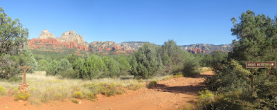
After following the connector trail for about 0.3 miles from its start at Chuckwagon, we found ourselves at FR 152. A sign (shown at right in the following photograph) directed us to the Brins Mesa Trailhead which is located on a loop just off the main road. The photograph was stitched together to show the trail junction at the forest road. The small sign (shown at left in the following photograph) shows the end of Brins mesa Connector. Following the sign on the right will take you about 75 yards along the short loop road to the actual Brins Mesa Trailhead. The loop then returns you to the forest road.

The small sign mounted atop a cairn at the left marks the end of Brins Mesa connector; the somewhat larger sign at the right points the way to Brins Mesa Trailhead

The following map, posted at the Brins Mesa Trailhead, shows the Devil's Bridge Trailhead about 1.1 miles to the south, the Secret Canyon Trailhead about a mile north and the Vultee Arch/Sterling Pass Trailhead about 1.9 miles north. Also shown is the turnoff from Secret Canyon Trail to HS Canyon Trail about 0.7 miles north of the Secret Canyon Trailhead.

Excerpt from a Forest Service map posted at the Brins Mesa Trailhead on FR 152
We continued north on FR 152 for about a mile to the Secret Canyon Trailhead where we stopped for a midmorning snack. The actual trailhead where all the normal trail information signs are posted is located about a 100 yards down a dirt road from FR 152.

The following photographs show the sign pointing to the trailhead (below left) and the actual road leading to it (below right).

After our snack we proceeded down the short dirt road, crossed Dry Creek and headed north on Secret Canyon Trail. The trail was clearly marked, first by one of the rusty old metal signs (below left) found in the area and then a few yards farther on by a newer wooden sign (below right).

The trail up Secret Canyon was wide and well-worn, showing a lot of usage. It was actually ground down by passing feet so that we were walking on a thick layer of powdery sand. We were surrounded by junipers and manzanitas and occasionally, as we wound our way back and forth across across the wash, even found a few puddles of water. These puddles would be gone in another day or so if it didn't rain.

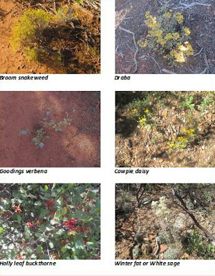
About the only flowers we had seen to this point had been a lot of broom snakeweed on Grassy Knolls. But we now started to see a few more along the way. A sample of the broom snakeweed along with other flowers seen later in the hike are shown below.


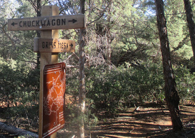
Just 0.7 miles from FR 152, we came to the HS Canyon Trailhead. The trailhead was marked by another of those attractive, rusty old metal signs (below left) that just seem to belong wherever they are found. Occasionally, through a break in the tree cover we could look ahead and see a half-moon (below right) lurking above the mountains.

One mile from the Secret Canyon/HS Canyon Trail junction, is a very faint trail that leads to the left, passing along the foot of a large protruding rock cliff and climbing sharply uphill for about 50 yards to a flat viewpoint surrounded by low-growing manzanita.

Turnoff to viewpoint
This is a great place to look out over the surrounding terrain and I have included a panoramic view stitched together from photographs made during last April's scouting hike.

Panorama from viewpoint – stitched from photographs made in April 2015
The trail follows close along the wash in the bottom of HS Canyon, passing through junipers near the mouth of the canyon and then entering a forest composed of oaks, a few ponderosa pines and manzanita. Below are shown a collection of acorns (left) gathered along the way and a manzanita (right) displaying its distinctive brownish purple bark among a profusion of green leaves.


Our total hiking distance, as measured from my GPS track, was 9.8 miles in and out. Only 3 miles of this was actually on HS Trail. Approximately 2.8 miles was along what used to be Gunslinger Trail but is now a section of Chuckwagon Trail, about 0.6 miles was on Brins Mesa Connector, two miles were along FR 152 and 1.4 miles was on Secret Canyon Trail. Luckily we only met one vehicle, an ATV on the forest service road, so were not bothered by dust.

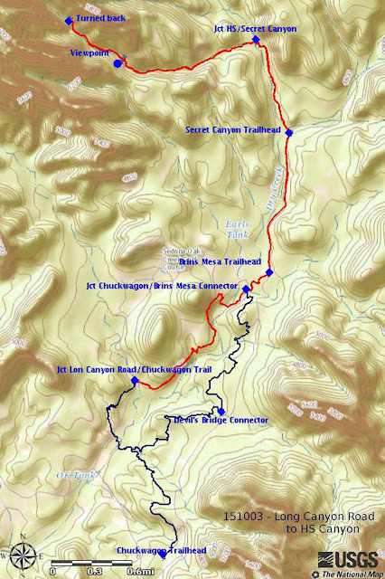
Our in-and-out track is shown in red on the map below. The section of track between Long Canyon Road and the junction of Chuckwagon Trail and Brins Mesa Connector Trail, although shown in red because it was part of this hike, is in reality a section of Chuckwagon Trail. It also was previously known as Gunslinger Trail. The dark blue section of trail is the rest of Chuckwagon Trail.


1http://thehikehouse.com/tag/van-deren-cabin

Friday, July 17, 2015

HS Canyon Trail by Way of Secret Canyon


I had read several reports of hikes on HS Canyon Trail and they all varied a bit as to how long the trail was. Additionally, I found one old trail map that showed HS Canyon Trail actually leaving HS Canyon and turning north along the foothills of Maroon Mountain to reconnect with Secret Canyon Trail near the intersection with David Miller Trail. But one thing the reports all seemed to agree on was that HS Canyon Trail turned off of Secret Canyon Trail about 0.7 miles from Forest Road 152.

Four of us set out on 22 April 2015 to determine for ourselves just where the trail would lead us. We drove from Cottonwood to Sedona on Hwy 89A, turned left onto Dry Creek Road and continued to the junction with Forest Road 152, also known as Vultee Arch Road (or on some maps, including Google Earth, Dry Creek Road). Personally, I think the road is renamed every few years just to confuse people.

A paved parking area and restrooms are provided at the start of FR 152 and there the pavement ends; the next 3.5 miles of road to the Secret Canyon Trailhead is very rough and should only be attempted in high-clearance, 4-wheel drive vehicles. To emphasize that point, the Forest Service has embedded a row of rocks across the road at its very beginning. The rocks are of sufficient height as to discourage drivers of low-clearance vehicles from even attempting to go further. We had come prepared with high clearance vehicles, but one was a rear-wheel drive pickup that we had to park along the way. We all just piled into the 4-wheel drive vehicle for the rest of the trip to the Secret Canyon Trailhead.
A short 50-yard driveway leads from FR 152 to the trailhead parking area. There is room for one vehicle to park alongside the forest road and, arriving at 0820, we were early enough to park there (right)
We four hikers (Lila Wright, Karl Sink, Phil Sullivan and the author) donned our packs and walked the short distance to the trailhead.

The trail information shown here (left) was extracted from a Forest Service sign posted in a prominent location at the trailhead. The trailhead is located on the southeast side of Dry Creek and one crosses the almost always dry creek to travel northwest on Secret Canyon Trail.

On the far bank stands a wooden sign (right), this is in addition to the rusty old iron sign that has long marked the start of Secret Canyon Trail. I guess someone decided to reassure those people who might be looking for HS Canyon Trail that they were headed in the right direction.

We followed Secret Canyon Trail through a forest of manzanita, juniper and oak for 0.7 miles, following along the dry creekbed that marked the bottom of the canyon, before we came to the HS Canyon Trail turnoff (left). The trail here was open, very distinct and easy to hike as we entered the mouth of HS Canyon and started a gentle climb. Gradually the manzanitas thinned in favor of more substantial trees, primarily oaks as seen below (below).

HS Canyon Trail winding its way up the canyon between the oaks

We expected to see a lot flowers on this late April day and were not disappointed. Although, strictly speaking, one of the most unusual plants we found was not technically a flower but rather a red miners lettuce. This was soon followed by an isolated western wallflower.

Red miners lettuce
Western Wallflower
Most of the way up the trail the wash at the bottom of the canyon was close on our right and, as we approached the point where my old map had said the trail turned right to follow along the foothills of Maroon Mountain, I kept close watch for anything which might suggest a trail leading in that direction. I saw nothing, so we continued on up the canyon heading toward Maroon Mountain.
Larkspur 
Lupine

Other flowers seen along the way included a larkspur and a lupine.

Eventually we crossed the wash and continued upstream along the other side. The trail now became a bit rougher and a little less distinct but still easy to follow. We also saw signs of recent trail maintenance such as trimmed branches and stacked rock cairns. The flowers, meanwhile, became more prolific.

Mixed bed of penstemons and larkspurs 

We saw a mixed bed of penstemons and larkspurs (left) and a western wallflower of a different shade of yellow (right) stopped for a snack along the way at a small open area, covered with a variety of flowers, just at the end of the recently maintained portion of the trail.


Larkspur, penstemon and western wallflower; Phil Sullivan at upper left

Just ahead we came to a rock cairn (right) that marked the end of any recent trail maintenance. At the cairn, we entered the wash and hiked along the dry streambed; an occasional small cairn indicated that others had been this way before us.

For most of the distance along here the bed of the wash was grass-covered and brush free; we encountered only the occasional large rock to navigate around or climb over. All in all it was relatively easy going. The photograph (left) shows two of the large rocks along with an informal cairn placed on top of one of them.

Lila is shown here (right) as she makes her way up a relatively clear stretch of the streambed. Note the flowers in the foreground of the photograph. We found larkspur and western wallflower all along here. Apparently, the creekbed retained just enough moisture to allow them to proliferate.

Eventually, however, we came to an area that was filled with a jumble of dead brush and living undergrowth. It was obvious that in order to continue we would need to leave the wash. There, to reinforce our decision to leave the wash, we found another small cairn (left) pointing the way.

After leaving the wash at the cairn, we found a few additional clues along the way in the form of an occasional very ancient tree trimming. There were also short sections of trail that could have been the result of human passage but were more likely made by animals. And soon enough we came to a spot near the head of what now appeared to be a box canyon ending at the eastern slope of Maroon Mountain. We could see what might have been a way to go a little farther by passing to the right under the overhanging cliff shown below but it looked awfully difficult and would have turned an otherwise pleasant hike into a chore.

Overhanging cliff near the end of HS Canyon

On the way back down the trail we noted a couple of flowering plants that we had missed on the way up.

New Mexico raspberry Cliffs fendlerbush

A New Mexico raspberry is shown here (left) along with a Cliffs fendlerbush (right).

The best viewpoint on this hike is located on a manzanita-covered hill, about a mile above the junction with Secret Canyon Trail.

Looking generally north from the viewpoint


Looking northeast from the viewpoint

The rest of the hike was an easy 1.7-mile trek along a gently downsloping trail and we were soon back at the Secret Canyon Trailhead.

I measured the round trip hike as being 5.0 miles. The maximum elevation was 5433 feet and the total ascent was 830 feet.

Our track is shown in red on the included map (next page).


Scouting Grapevine Gulch Trail


I had identified Grapevine Gulch Trail as being a relatively short hike, 2.7 miles one way, trail that could easily be hiked by the Skyliners as a 5.4-mile round trip hike. The trail is located in Grapevine Gulch on the Prescott Valley side of Mingus Mountain and the best way to reach the trail from Cottonwood would be to drive south across Mingus Mountain on Hwy 89A and then follow Powerline road, a dirt road, along the foot of the mountain to Grapevine Well which marks the trailhead.

It was a sunny day when Lila Wright, Karl Sink and the author set out early in the morning of 18 February 2015 to explore the trail. Although there were only the three of us and we could have ridden in one vehicle we chose to take two because the dirt road we would follow was unfamiliar to us. The two vehicles were a 4-wheel drive pickup and a rear-wheel drive pickup. This would enable us to determine whether 4-wheel drive was necessary and also provide a measure of safety in the event of a breakdown in a remote area.

From the Cottonwood Safeway parking lot it was 21.3 miles across the mountain to the turnoff onto Forest Road 643 (Powerline Road). The first 0.9 miles of FR 643, to the junction with FR 151, was heavily traveled and maintained in excellent condition. However, from that point on, the going became pretty rough in places as the road wound its way over and around hills and across deep washes while generally following the power line. I was happy to be driving a 4-wheeler. On the other hand, Karl managed to follow all the way with his rear-wheel drive vehicle. In the final analysis, a 4-wheel drive vehicle is highly desirable and a high-clearance vehicle is a necessity.

After another 4.8 miles, 6.1 miles from Hwy 89A and a short distance after FR 643 turned sharply east, we came to an intersection with FR 9002V. Forest Road 643 turned right and continued south at this point, but we continued straight ahead on FR 9002V until it turned left and headed north. This is the Grapevine Gulch Trailhead, but we drove straight ahead for another 0.1 mile to park at Grapevine Well.

The map (right) shows the route (see dark yellow track) we took along Powerline Road (FR 643) and FR 9002V to Grapevine gulch Trailhead.

The map insert (left) details the area from the FR 643/9002V junction to the trailhead and also shows Grapevine Well.


As noted, we actually drove another 0.1 mile past what we took to be the official Grapevine Gulch Trailhead. There, just short of the well, we came to a gated fence (below) and parked outside the gate to start our hike.

On the other side of the fence the trail follows an old road, see the faint track just to the left of the sign, that leads up the slope and follows along the hillside before returning to the bottom of the gulch. After crossing the fence, we paused for a few minutes to look around at Grapevine Well and its associated windmill and water tank.


Lila and Karl at Grapevine Well

The roughest and steepest part of the trail was the short section of old road that climbed up the hillside, but it was a short stretch of the trail. When we reached the high point on the hill, just before dipping back to the bottom of the gulch, we could see large rock outcroppings near the streambed below; this was undoubtedly the reason that the road builders had chosen the hillside in that area. On the other hand, a cow trail did follow along the bottom of the gulch and we could have followed that instead of the old roadbed.

In any case we were soon enough back in the bottom of the gulch, following the remains of the old road as it wound its way back and forth across the streambed. At the time of our hike the streambed was bone dry for most of the way, so we had no problem crossing it. A section of the streambed, about 0.9 miles from the trailhead, with the old road shown running along its left bank is shown below.

Grapevine Gulch dry streambed with trail (old road) shown at left

About 1.4 miles from the trailhead we came to the remains of an old mine. The only reference I could find to a mine at this location identified it as a “Cobalt shaft; Cobalt prospect; Walker prospect [?])1The source also indicates that it is a narrow (knife edge to 14 inches wide), 15-foot vein deposit of partly oxidized, altered gabbro (intrusive igneous rocks) containing relics of sulfide, possibly cobaltiferous arsenopyrite.

Although all we saw was the tailings pile alongside the streambed, the source said the workings included “a 28 foot long opencut leading to an 18 foot long adit (horizontal or nearly horizontal entrance to a mine). A 20 foot winze (minor connection between two levels in an underground mine) was sunk at the portal2”.

Cement Spring is located near the old prospect mine. I had seen the name on the map and wondered how it got its name. One look at the spring (right) answered that question. Someone, probably the miners, had dug the spring out and reinforced the walls with rocks cemented together. It was now more a shallow well than a spring. Although no water entered the streambed at this point, there was water in the spring.

From Cement Spring, the Forest Service map indicated that the trail continued for another 1.2 miles and ended at Trap Spring. When we arrived there, we did find a mere trickle of water in the streambed as shown in the below photograph. Contrary to the map, the trail continued on past the spring and, as it appeared to be well used and easy to hike, we decided to continue on up the gulch.

A trickle of water in the stream; trail continuing up the gulch (right)

About 0.2 miles above Trap Spring a trail branched off to the right, leading up a side wash to the northeast. We continued along the trail in Grapevine Gulch, heading directly north, for another 0.5 miles before deciding to turn back. The trail was still clear and easy to hike, sloping gently as it made its way up the gulch, and we wondered who had extended it. I later determined that the extension was the work of mountain bikers. The extension crosses the ridge ahead, follows Ash Creek for a distance and then returns to Grapevine Gulch Trail by way of the fork we had noted just above Trap Spring.

We stopped along the way for a leisurely lunch but still found ourselves approaching the end of our hike early in the afternoon. The below photograph, looking across Prescott Valley from the mouth of the gulch, was taken near the end of the hike. The Grapevine Well Windmill is located just beyond the rock formation shown right of center. Although the road looks good here, it is very rough ahead.

Looking across Prescott Valley; top of windmill visible above the rock formation

After finishing the hike, we decided that we would continue south on Powerline Road to Hwy 169 for the return home. That idea didn't work because the road is closed at a locked gate a short distance ahead. Finding ourselves stymied in that plan, we decided that we would instead go west from Powerline Road, following a road that we were sure would take us to Fain Road. We would then follow Fain Road north to Hwy 89A. Unfortunately, we soon came to another locked gate. This closure was emphasized with a dead coyote hung on either side of the gate. We weren't sure but
thought that might be a message for trespassers. One of the coyotes is shown here (left).

We gave up on all alternatives and returned home the way we had come.

After uploading my GPS track, I measured the round trip hike as being 6.4 miles. The maximum elevation was 6132 feet and the total ascent was 891 feet.

Our track is shown in red on the included map (next page). The purple track is the bike trail that loops across the ridge, down Ash Creek and then back across to rejoin Grapevine Gulch Trail above Trap Spring.


1 Cobalt shaft; Cobalt prospect; Walker prospect [?])

2 Ibid