Tuesday, June 10, 2014

Hiking the Inner Basin Trail


I had already hiked most of the other major trails in the San Francisco Peaks area – Humphreys Peak, Weatherford, Kachina, Abineau, Bearjaw, Bismark Lake Loop and Waterline – I now wanted to hike Inner Basin Trail from Lockett Meadow to Weatherford. Three fellow hikers -- Gordon Bice, Jim Manning and Jim Quin – agreed to accompany me. 10 June 2014 was a beautiful day and we left Cottonwood at 0700 in high spirits. Our route from Cottonwood took us north on I-17 to Flagstaff. From there we continued north on US 89 to the Sunset Crater exit, turned left and drove 4.5 miles on a well-maintained dirt road to Lockett Meadow.

Even a flat tire as we approached Flagstaff did nothing to dampen our mood. We simply stopped in the dead zone between the St Mary's Road exit lane and the freeway proper and replaced it with the spare. With three people to change the tire and me to hold the lug nuts we were soon on our way again.

Although we saw a number of campers before we reached Locket Meadow and there was a moderate amount of traffic on the road in, the Locket Meadow Campground was essentially empty, just a car here and there in the numbered slots. As for trailhead parking, ours was only the second vehicle in the lot.

The first time I had hiked on the Inner Basin trail, that time only the lower section of the trail, I had left Locket Meadow at a different place and followed along an old road to Jack Smith Spring. That section of trail was about 1.6 miles in length. Since about 2010, however, the trail has been rerouted and now starts at the very end (southwest perimeter) of the campground at a well-marked trailhead. Several parking spots are reserved nearby for day hikers.

As for the trail itself, it now follows for about 0.4 miles along the very edge of the 2010 Schultz fire. Upon leaving the trailhead one almost immediately comes to the burn area and then hikes for some distance along a trail with devastation on one side and an untouched forest on the other. The trail then dives into a lush untouched forest pine and fir trees, turning to mostly aspen about 0.8 miles from the trailhead. One mile from the trailhead, we started a series of switchbacks that lifted us through a forest now composed almost entirely of aspen. Oh, we saw the occasional evergreen among the white trunks. But essentially this was an aspen forest and remained so until we reached the Waterline Trail, about 1.8 miles from the trailhead by my GPS.

The quiet stillness of the aspens, broken only by the gentle sound of the wind and the occasional chirping of a bird, had an almost mesmerizing effect and made one want to linger. We paused to look around in awe at the stark contrast between the white of the aspen trunks and the emerald green of the grass-covering the forest floor.

Aspen forest traversed by the switchbacks

When we emerged on Waterline Trail at the end of the switchbacks, we still had 0.3 miles to go before reaching Jack Smith Spring. In other words, rerouting the trail away from the old road and creating the switchbacks through the aspens had added half a mile.

In my opinion it was well worth it. The switchbacks are well-engineered and the new trail allows one to spend additional time in one of the most beautiful spots I have ever visited.

Now on Waterline Trail (also Inner Basin Trail) we continued up an old road at a very gentle slope until we arrived at Jack Smith Spring. The road,, built to service the waterline, once crossed a road running the length of the Inner Basin at the spring. Now, however, the section of road between Locket Meadow and Jack Smith Spring is closed off and almost completely indiscernible. Meanwhile, this section of Waterline Road and the road running on up to the Inner Basin are closed to all but maintenance vehicles. Not even horses are allowed in the Inner Basin.

After looking around at the utility buildings and the old cabin located at Jack Smith Spring, we headed on up the Inner Basin Trail, now following the road still used by Flagstaff to maintain the water system. About a tenth of a mile distance up the road we came to Pumping Station # 11. The pump itself in enclosed in a pre-fabricated wooden structure fitted with lifting lugs, perhaps indicating that it was transported by helicopter.

 Pumping Station # 9
We continued for another 0.5 miles to arrive at the Inner Basin. Here we also found Pumping Station # 9 (right). The building was of the same pre-fabricated construction we had noted at Pumping Station # 11. We did not see a Pumping Station #10.

additional building
There was an additional building (left), of the same pre-fabricated construction as the two pumping stations, installed nearby. It looked very much like a bus stop shelter. I don't know why it was installed there, perhaps for shelter in an emergency.

Looking straight ahead (southwest) we could see, very faintly, the old road that was Weatherford Trail, traced below in red, running along the slope of Fremont Mountain. Our trail, the Inner Basin, would end at a junction near the rightmost end of the red line.

Showing Inner Basin Trail running through the basin toward Fremont (center)
 and its terminus at Weatherford Trail on Fremont
The saddle seen to the right of Fremont Mountain is Fremont Saddle. Doyle Saddle, hidden here by the shoulder of Doyle Mountain, is located to the left of Fremont, between Fremont and Doyle. The saddle names are from a USFS map published in 2000. Other maps, including the USGS map used for this report, reverse these names.

The trail to this point had been all uphill and that did not change. Sometimes it was quite steep, sometimes less steep, but always uphill. The path through the open Inner Basin meadow was only gently uphill and the hiking was easy for about 0.4 miles. At that point the trail, still following an old road, angled left to leave the open meadow, cross the wash below Doyle Spring and enter a forest of small trees. The trail now became steeper and had a lot of loose rocks. We came to another meadow as we approached the base of Fremont below the slide area. The spot where Weatherford Trail crosses the slide (red line) appeared almost close enough to touch.

Close up view of Fremont Mountain showing a section of Weatherford Trail (red)
From here the trail angled to the right, heading almost directly toward Agassiz Peak and we reentered the forest. Now the trees were larger and began to offer a modicum of shade. The trail still followed along an old roadbed and we were still closely following the wash in which Doyle Spring is located. At one point we saw a waterline access riser leading to the conclusion that Flagstaff is (or at least was) collecting water from a source farther up the wash, probably accounting for the old road we were following.

We were now finding patches of snow in shaded areas alongside the trail. We had been expecting another set of switchbacks to take us up the mountain and we were not disappointed. About 0.9 miles after we angled left at the end of the Inner Basin meadow to cross the wash below Doyle Spring, we came to a sign telling us to leave the old roadbed and make our way directly up the mountain. This was the start of the switchbacks. The old roadbed appeared to continue on up the wash. However, my Arizona topomap shows that it ended at the base of Agassiz, a short distance ahead.

Five quick turns on the switchbacks and a short, straight climb brought us to Weatherford Trail. We ate lunch and then took a group photograph, not a very good one, before heading back.

Left to right: Jim Manning, Gordon Bice and Jim Quin
According to my cleaned up GPS track, the elevation at the beginning of the hike was 8688 feet and the end was 10887, so we climbed about 2288 feet. Because my GPS did not lock in immediately when we started, I clipped the track at Weatherford Trail and just measured the return trip. That was 4.4 miles, meaning that we hiked 8.8 miles round trip.

The included map (next page) shows our GPS track in red. The yellow track shows the pre-2010 section of trail before it was rerouted. The blue track is a section of the Weatherford Trail.


Monday, June 2, 2014

Pivot Rock Canyon


Although we expect to hike sporadically in the high country during the summer, a 31 May 2014 hike in Pivot Canyon was the last scheduled hike for the season.

We left Cottonwood at 0700, our normal starting time for May hikes, and drove east on Hwy 260 for about 43 miles before turning left onto Forest Road 144. The turnoff is just before you reach milepost 249; in fact, one can actually read the numbers on the mile marker from the turnoff. We traveled 1.8 miles on FR 144, turned left onto FR 149 and traveled 1.1 miles, turned right onto FR 142 and traveled 2.1 miles to the unmarked trailhead at Toms Creek. There is a wide graveled area in the bottom of Pivot Canyon where FR 142 crosses Toms Creek, providing ample parking.
We were greeted by a scattering of bright yellow primroses (right). I have only seen these once before, on the Lower Cedar Bench Trail.
As we continued the easy hike up the gently-sloping canyon, following an ATV trail, I noted a beautiful young oak tree (left) growing in isolation on the canyon floor and a thriving young aspen (right). Later, in the upper reaches of the canyon, I saw other young aspens along with the trunks of old, mature dead ones.

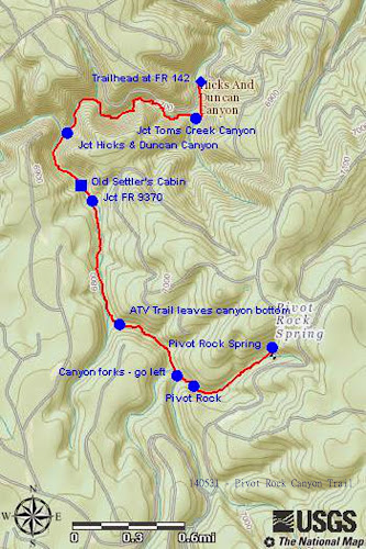
Just 0.2 miles upstream from our stating point, an old road crosses the canyon. This is where Toms Creek flows in from the left (southeast). We didn't investigate the old road; however, it appears passable by 4-wheel drive vehicles. The main canyon at this point turns and continues upstream to the west for about a mile to the mouth of Hicks and Duncan Canyon (sometimes called Corduroy Wash because a wash of that name joins Hicks and Duncan about 1.5 miles above). Pivot Rock Canyon then turns and runs generally south for about 1.6 miles before it turns to the southeast past Pivot Rock and then gently curves to run northeast until it ends at Pivot Rock Spring.

About 1.5 miles from the trailhead at FR 142, there is an old settler's cabin (left). That has, according to Daisy Williams, who came this way several years ago, been partially restored in recent years. We stopped there for a short rest and to take a group photograph


Left to right: Betty Wolters, Chris Jensen, Beverly Sass, Daisy Williams,
David Murrill, Lila Wright, Jim Manning and Joyce Arregui – photograph by
the author
Jim Manning was hiking with a bad leg, having previously damaged a muscle, and didn't intend to hike all the way to Pivot Spring. He had anyway hiked the trail in April when we did a scouting hike. He thus decided to stop off at the cabin, read a book for awhile, and then return to the trailhead to wait for us.

About 0.1 mile upstream from the old cabin, what remains of Forest Road 9370 enters the canyon. This section of the road appears long unused; however, it is still easily discernible as it leads steeply up the canyon wall. As a matter of fact, we left the canyon by way of this road when we did the scouting hike last month. It is still posted as FR 9370 on the upper end.

After another 0.6 miles upstream from FR 9307, we came to a parting of the ways between the hiking trail and the ATV trail. As shown in the below photograph, the ATV trail leaves the canyon bottom at this point while the hiking trail continues up the canyon floor.

ATV trail leads to the right up the canyon wall; the hiking trail is straight ahead
The trail for the rest of the way is still very easy to follow although in at least two instances ATV trails descend from the right canyon wall. I followed one of those on the scouting hike and found that it took me to an old road, still in use, that leads up a draw and back down the other side to rejoin the trail.

From this point the canyon closes in a bit but is still wide enough that one can walk alongside the rocky streambed. The trail is almost level and easy to hike. But about 0.4 miles from where the ATV trail left the canyon floor and approximately where I returned to the trail on the scouting hike after following the ATV trail, the canyon forks and it is not really clear which branch is Pivot Rock Canyon. Just remember that this is where the canyon turns southeast and take the left branch.

Canyon fork – go left – do not take the path leading straight ahead
At this point, go directly up the left fork. The apparently well-trod path leading up the slope between the two forks ends a few yards ahead.

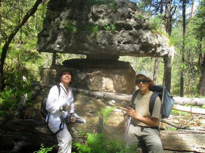
The rock formation which gives the canyon its name lies just 0.1 mile, ahead just above the trail on the left side. For the best view climb the slope from the upstream side of the rock.

Pivot Rock – photographed in April 2014


We took a couple of photographs while at the rock.
The author – photo by Betty Wolters 

Joyce Arregui and Betty Wolters

The canyon floor this stretch was carpeted with a blanket of beautiful, bright green ferns.

Upper Pivot Rock Canyon blanketed with ferns
Just upstream from Pivot Rock we found what remains of the rear passenger compartment of an ancient automobile and wondered how in the world it ever wound up at this inaccessible spot. The photograph below was taken in April 2014.

Remains of old automobile

We were now very near to Pivot Rock Spring where we expected to eat lunch before turning back, so we moved right along.

When we arrived at the spring we found another party, a family group with several children, ranging from a couple of teenagers to a three-months old baby, was already there and were preparing to enter the cave from which the spring flows. 

Cave from which spring flows
I followed them in along with Chris Lila and Daisy. Although not apparent from outside, the cave opens up after about 12 yards into a chamber large enough to stand and move around in. A hiker is shown below entering the large chamber.

Hiker entering large chamber

In contrast to the outside temperature, it was quite chilly inside the large chamber.

Inner chamber of cave at Pivot Rock Spring
I am told that the cave runs about an eight of a mile into the mountain and that one can leave the inner chamber by one opening and return by another, making a loop in the mountain. These entry and exit openings are pointed out by the red arrows in the above photograph. We chose to defer crawling through the loop to another day and climbed back out to eat lunch.

We had identified a several flowers during the April scouting hike. Now a month later even more were in bloom and these were entirely different than the April flowers. They are all included in the following photographs, those from today's hike first, along with notations as to when photographed.

Claret cup cactus – May 2014
Green gentian – May 2014

Thermopsis – May 2014

Bush pea (?) - May 2014
Wild rose – May 2014

Arizona honeysuckle – May 2014
The columbine (below), was found growing in a naturally-formed flower pot located in a large isolated boulder along the trail in the lower part of Pivot Rock Canyon. Apparently there was just enough moisture to keep it alive. It was photographed in May 2014

Columbine in natural flower pot - May 2014

Scrambled eggs – April 2014

 Canadian violet – April 2014

Hookspur violet – April 2014

Creeping mahonia – April 2014
This was an easy hike. The round trip distance was 6.6 miles, the trailhead elevation was 6685 feet and the elevation difference was only 372 feet.

Our GPS track is shown in red on the included map (below). Points of interest discussed in the narrative are also noted on the map.


Sunday, May 25, 2014

Visit to Alvarez Ranch


On 25 May 2014 the Skyliners visited the old Alvarez Ranch on the Verde River. The long-abandoned ranch, located on the north side of the river between Sycamore Creek and Railroad Wash, is owned by the National Forest Service but is not accessible by any official trail or road. We crossed the river at location N34 52.109 W112 06.124 and entered the site at the old ranchhouse. Below are shown the hikers in our group and the ranchhouse as viewed from the river.

Left to right: Chris Jensen, James Quin, Donna Goodman, the author, 
Lila Wright, Gary Jacobson and David Beach

Old Alvarez Ranchhouse

As we climbed up to the old dwelling, we noted the work of beavers along the bank. Two of several examples are shown in the below photographs.

The work of beavers at Alvarez Ranch 

Lila provided a 28 February 2012 article written by Jim Hutchison and published in the Camp Verde Bugle Newspaper that supplies information about Spanish Immigrant Rosendo Alvarez, his family and descendants (see footnote below)1. One of Rosendo's children, Emilia Alvarez Carillo, now living in Clarkdale, recently celebrated her 97th birthday.

Located just a few yards from the old ranchhouse are a well and, a bit farther away, an outdoor privy.

Well
Privy
There are also several other structures still standing at the ranch site. Some of these are of wood construction, but were fairly well-preserved. Shown below are a shedlike structure and a frame building that might have once been a chicken house. At least it reminded me of those I was familiar with in my youth.

Shed and frame building constructed of wood

There were also two stone buildings, one still in fairly good condition. They might have been used to store grains and other produce.


Stone structure of unknown use
The old ranch was a most pleasant place and we were tempted to linger, but we had arranged to be picked up at noon, so soon continued on our way. At first we following a faint trail, then an old road bed downstream toward what we expected to be private property with two occupied dwellings.

We retreated to the river until we thought we had bypassed the private property. Looking at a map I later located, it appears that the parcel of private property located along the road we followed from the Alvarez Ranch extends to both sides of the river at one point.


It appears that the best way to entirely avoid private property on the way to Alvarez Ranch is to Park at the Sycamore Canyon Trailhead, take Parsons Trail down to Sycamore Creek, follow Packard Trail across the creek and then bushwhack for about 0.8 miles to bypass the section of private property. After reviewing the “bushwhack” area in Google Earth, I believe that about 0.3 miles of that 0.8 mile section would be across flat, relatively open terrain.” On the below map, I have labeled this the north bypass. I have also shown a possible south bypass. To take that route, one should drive on past the Sycamore Trailhead, park at a locked gate (see “Park – south bypass”) and follow approximately the route shown in blue. There is a road that runs down the hill beyond the locked gate, crosses Sycamore Creek and continues on to the dwellings located on the private property.

Detail map of the area around the Sycamore Creek junction with the Verde River

The north bypass should be easier. Although it does have about 0.5 miles of steep slope to cross, it appears to vary in elevation by less than 50 feet. Taking the south bypass would be about 0.5 miles shorter, but it would involve crossing the river twice.


The possible routes to the Valdez Ranch are shown on the included map (below). The yellow line outlines the private property, the green track is Packard Trail, the red track includes the north bypass route and the blue track includes the south bypass route.

The total round-trip distance by the north bypass is 5.0 miles. The maximum elevation is 3750 feet and the difference is 150 feet.


1http://cvbugle.com/main.asp?SectionID=74&SubSectionID=702&ArticleID=33804

Sunday, April 20, 2014

Crook Trail in Copper Canyon


On 19 April 2014 seven Skyliners hiked General Crook Trail in Copper Canyon. We first positioned one car in Camp Verde at the Copper Canyon Trailhead, located on Forest Road 136 about 0.9 miles from Salt Mine Road. We then took Interstate 17 across the Black Hills to the Hwy 169 intersection and turned east on the dirt road to Squaw Peak (now FR 732, but possibly still numbered FR 68d). About 0.3 miles from I-17, we turned left onto FR 136 (possibly still numbered FR 684d). This is a rough road suitable only for high-clearance or 4-wheel drive vehicles. We could have continued for another 1.4 miles on FR 732 and turned on FR 9603J to bypass the first 1.8 miles, the roughest part, of FR 136. The route we took to park at the crest of Copper Canyon is shown below in blue. The alternate route (FR 9603J) is shown in green.

Map showing route (and alternate route) to parking at the crest
of Copper Canyon

We parked at the crest of the ridge at the very top of Copper Canyon, donned our gear and then posed for a group photograph before starting our hike.

Left to right: Jim Manning, Daisy Williams, Gary Jacobson, Betty Wolters,
Kwi Johnson and Lila Wright – author not shown


About 200 yards below the crest we started to see flowers. The first sightings were desert marigolds, feather daleas and 4 O'clocks.

Desert marigold/Feather dalea
 4 0”clock


After those first sightings we found flowers all along the trail. The next photograph (below, right), shows desert marigolds and feather daleas with a cliffrose shrub as a backdrop.

The road we were walking on, although fairly steep, did provide good footing, allowing us to devote much of our attention to our surroundings rather than next step. At some time in the past the old road had been moved a few yards up the hill and the older roadbed was clearly visible just below us. We really had no way of knowing whether it was the route of the original General Crook Wagon Road. However, I suspect that it may have been relocated numerous times over the years in response to slides and washes.

At one point we came upon a particularly attractive clump of desert marigolds (left) with a few sprigs of showy penstemon set among them and a hint of globe mallow arranged above.

As we neared the old stage station located just over a mile down from the top of the canyon, we noted a number of colorful rocks that had tumbled down the mountainside during construction of I-17 as the contractor blasted away the mountain above.

Rock blasted from mountain when constructing I-17
We then arrived at the old stage stop, a most pleasant place with a grove of hackberry and Arizona walnut trees and a steady flowing stream nearby.

Photograph taken standing near foundations of old stage stop building
There is a year-round spring just up a side canyon from where the old stage stop is located and water is always flowing in the nearby stream and on down the canyon from here. The spring is simply referred to on all the maps I have seen as “Copper Canyon Water,” apparently having no other name.

Wirelettuce (or Desert straw)
  Showy penstemon
Below the stage station flowers continued to grow in profusion, particularly where the earth had been disturbed when constructing the power line. Near one particular power pole we found the most perfectly-formed clump of wirelettuce (desert straw) that I had ever seen along with a veritable jungle of showy penstemon.

Firecracker penstemon
  Primrose
These were closely followed by a fiery red firecracker penstemon and a clump of primrose just past its prime.


A little farther down the trail was a single
salt cedar (tamarisk) plant (left) growing alongside the stream. The tamarisk, a native of Eurasia, is classified as an invasive species and the subject of countless eradication efforts throughout the desert southwest. The plant limits competition by taking up salt from deep ground water, concentrating it in its foliage and, from there, depositing it into the soil where it is detrimental to other plants. In spite of this, the tamarisk is certainly a beautiful plant at certain stages of its development.

Fleabane  
Just after we had paused to admire some fleabane growing in splendid isolation beside the road, we came upon a cave that, although having hiked this way several times in the past, I had never before noticed. Kwi checked it out and reported that it was about 25 feet deep and then turned and continued for another eight or ten feet.

Cave at side of FR 136
Antelope horn 
We found several more flowers, all pictured here, as we drew near to the small, lovely waterfall where we planned to eat lunch.


Groundsel


I climbed down to the top of the waterfall and snapped a couple of photographs before climbing back up to eat and settle in for a good noon nap.  The Copper Canyon Waterfall, seen from the top, is shown in the below photograph.

The Copper Canyon Waterfall from the top
Gary had already found a nice soft spot in the shade of a juniper tree and, shoving a few dried cow chips aside, I joined him there. I really don't know how long we slept, but do know that I was much refreshed.

It is just a little under two miles from the waterfall to the Copper Canyon Trailhead and we had excellent views down the road ahead, across the Verde Valley and beyond the Mogollon Rim to the San Francisco Peaks.

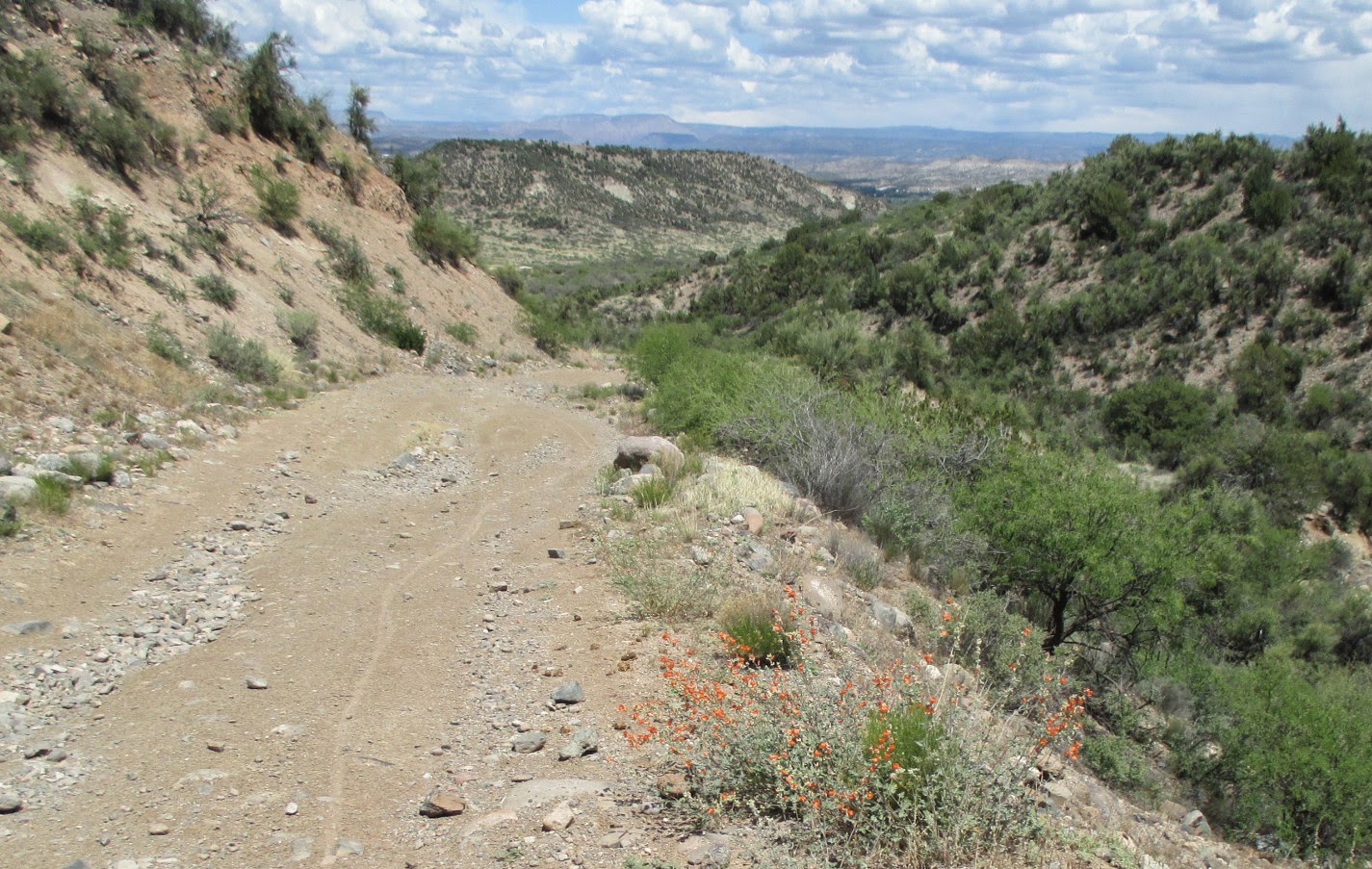
Looking down the road ahead and across the valley to the peaks

This one-way hike was 6.1 miles, the trailhead elevation (where we parked) was 4769 feet and the elevation difference was 1514 feet.

Our GPS track is shown in red on the included map (below)