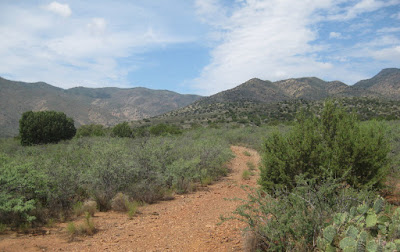
This
was an unanticipated hike. Still recovering from surgery, I had not
planned to hike for another month. However, Lila Wright, the
Skyliner hike leader had proposed a hike at Bismarck Lake, northwest
of the San Francisco Peaks, for Saturday, 27 July 2013 and I dearly
wanted to go. To make sure I was up to that hike, I decided to do a
trial hike on Thursday, two days before the Bismarck hike.
If
no one else was available to hike with me on the proposed date, I
planned to park at the intersection of Old Hwy 279 and Ogden Ranch
Road. I would then hike up Ogden Ranch Road (a dirt road) to the
Black Canyon Trailhead and return. I figured that would be a little
over five miles round trip. But luck was with me, and another
Skyliner hiker agreed to hike with me. Since there were now two of
us, we decided to drive on to the Black Canyon Trailhead and hike up
the actual trail instead of on the dirt road.
When
we arrived at the trailhead, we found that Ogden Ranch Road has now
been blocked off 0.7 miles short of where it previously ended, and a
new trailhead with ample parking has been built. A sign clearly
marks the new start of Black Canyon Trail and clearly prohibits all
motorized vehicles.
 |
Sign at start of Black Canyon Trail
|
Leaving
the trailhead, the trail follows for about 0.2 miles along a track
previously used by ATVs and then passes through a gate (the first of
two).
 |
Trail between trailhead and first gate
|
 |
First gate located at lower end of new section of Black Canyon Trail
|
Just
a few yards beyond the gate, the trail dips into a wash (actually
more a canyon) downstream from Quail Spring. Looking across the wash
we could see the trail climbing out on the other side.
 |
The trail can be seen (center) climbing out of the wash on the other side
|
The
below photograph, taken from the other side of the wash, shows the
section of trail on which we descended.
 |
Looking back the way we had come
|
The
trail wound its way up the mountain, zigzagging in and out as it made
its way around the shoulders carved in the mountain slope. Soon we
were abreast of the arroya which can be seen just up the street
(Arroya Vista Drive) from my house. I am convinced that the street
must have been named after the wash (arroya or arroyo).
 |
Wash (arroyo or arroya) visible from Arroya Vista Drive near my house
|
Approximately
0.7 miles after we had passed through the first one, we came to a
second gate.
 |
Second, upper, gate on new section of trail
|
About
0.3 miles beyond the second gate, we came to the end of the new
section of Black Canyon Trail. It was, according to my GPS track,
2.2 miles in length. We had now hiked 2.2 miles and I wanted to go
for 2.5, so we continued on for another 0.2 miles. I stopped there
because the reading on my GPS was actually 2.5 miles and because
there was a nice shady spot in which to rest. However, when I later
downloaded and measured the track, it was only 2.4 miles. That was
close enough.
 While
I settled in for my rest (actually a short nap) my companion hiked
around the next shoulder to see what was ahead. He soon returned to
report that only more shoulders were visible ahead and took this
picture of the author (see photograph at right by
hiker using my camera) resting in the shade.
Unfortunately, I had left my camera in video mode and had to cut the
picture from a video clip.
Since
this was my first after surgery hike, I knew that Rosemary would be
worried, so I used my cellphone to call home and let her know that
we had made the planned distance and were now headed back.
We
met two other hikers on the trail as we neared the second gate. They
were a couple trying out new hiking boots in preparation for a
forthcoming expedition to Nepal.
When
I returned home and downloaded the GPS data, I found that (as noted
above) we had hiked 2.4 miles one way, or 4.8 miles round trip.
Again, close enough to my goal of 5-miles. According to my GPS
track, the elevation gain was 860 feet and the highest elevation was
4770 feet.
Our
GPS track is shown on the two included maps (below). The new section of trail is shown in red
and the replaced section in yellow on the first map. The second map
shows the entire 8-mile length of Black Canyon Trail, including the
mile added by the new section of trail.
 |
| Lower Black Canyon Trail |
 |
| Entire Black Canyon Trail |
No comments:
Post a Comment