 We
set out on 19 January 2013 to hike the Mountain. Having already
hiked Mooney Trail to the top of Casner three times, I was anxious to
try the Casner Mountain Trail. Ron Grafe who has not hiked with the
Skyliners for awhile had already contacted me to say he would join
us; then looking up after preparing the sign-in sheet, I saw a
vehicle sporting the familiar Bice Electric sign (right)
and knew that Gordon Bice, recently too busy to hike much, was also
with us today.
The
day was bright and sunny and we set out for the trailhead in good
spirits. We drove north on Hwy 89A to the Sedona Waste Treatment
Facility and turned left onto FR 525, turned left onto FR 525C
(Sycamore Pass Road) about 2.8 miles from Hwy 89A, continued on past
the well-traveled FR 761 (Bill Gray Road) turnoff and arrived at the
trailhead just across Coffee Creek after traveling 7.2 miles on FR
525C. The Forest Roads, both 525 and 525C had recently been graded
and were in very good condition.
 The
start of the trail is marked by one of those sturdy, almost
indestructible old rusty trailhead signs (see
left) that are seen on area trails of a certain
vintage. Only a small parking area is provided, just large enough
for a single vehicle, perhaps two with care. However, additional
parking is available alongside the road.
The
trail leads past the sign down to the bank of Coffee Creek (usually
dry) and connects with a very faint old road that leads across a side
wash and continues, at a rather steep incline at first, along the
slope on the other side until it reaches the service road for the
Sycamore Substation power line after about eight-tenths of a mile and
an elevation gain of some 550 feet.
The
Casner Mountain Trail was apparently built by the Casner family to
drive cattle from the Verde Valley to the Mogollon rim for summer
grazing. It was later used to build and maintain the power line. It
is still used as a service road for the power line, but is normally
closed to public travel by motorized vehicles. I think the section
of trail we followed from Coffee Creek up to join the service road
(about 300 yards beyond the gate barring motorized vehicles) must
have been a part of the original cattle trail.
After
joining the service road, the trail runs straight up the mountain for
about eight-tenths of a mile, at first rising at a gentle slope, but
becoming ever steeper, rising another 600 feet or more.
 |
Looking up the trail to Casner Mountain ahead
|
The
trail then starts a series of switchbacks, a total of nine by my
count, to rise an additional 700 feet or more in the next nine-tenths
of a mile.
At
the beginning of the switchbacks we paused to take a group photograph
(below) and to look down on the
Robbers Roost formation.
 The
photograph here (see right) shows
Robbers Roost. The much photographed Robbers Roost cave is located
on the opposite side, just below the rim at the top of the formation.
After
a short rest we gathered our packs and resumed our trek along the
switchbacks toward the top of the mountain. The total elevation gain
would be about 2200 feet and we had done a bit less than half of
that.
As
we climbed higher we could look back down the mountain and trace our
path, following closely along the power line, up the lower slope to
the start of the switchbacks. Lifting our gaze a bit we could see
down Verde Valley to the mist-shrouded White Hills beyond Camp Verde.
The bright morning sunlight filtering through the mist served to
give the whole scene an almost surreal look.
 |
Looking back the way we had come from the switchbacks on Casner
Mountain Trail
|
At
the sharp turn of the ninth switchback we came to what I thought was
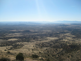
the best viewpoint of the entire hike. We could look out across
Sycamore Pass and on across Black Mountain to the Black Hills.
Shifting
our focus a bit to the west we had a clear view down Sycamore Canyon
as it would its way toward the Verde River Canyon.
 |
Looking down into Sycamore Canyon from the Casner Mountain Trail
|
We
still had almost another mile to go and something over 600 feet to
climb to reach the top, so we didn't linger very long at this
viewpoint.
We
came out at the top of the mountain in a sort of saddle with a small,
rocky rise to the left and another to the right. The trail ahead had
a thin, patchy layer of fast-melting snow. I had started with the
notion of hiking on along the top of the mountain to connect with the
top of Mooney trail some 3 to 4 miles ahead; however, that now looked
a muddy, miserable prospect, and we decided to climb to the summit
for lunch and then turn back.
But
which of the small uprisings was the actual summit. The one to the
right appeared higher, so we went there for lunch. A later look with
Google Earth indicated that we had chosen incorrectly, the other rise
was shown as higher by about ten feet at 6810 feet. However, the one
we settled on for lunch gave me a GPS reading of 6840 feet. Of
course a reading on my instrument taken at the top of the other rise
might also have also been higher than shown on Google Earth.
Right
spot or not we had great views all around for lunch, we could see the
snowy path ahead that we had chosen not to take, a view that only
validated our decision to turn back here.
 |
Trail running north with the power line across the top of Casner Mountain
|
Looking
to the northeast from our perch, we also had a clear view of the San
Francisco Peaks.
 |
The San Francisco Peaks seen from Casner Mountain Summit
|
 Ron
Grafe told us of a ceramic figure he had seen, mounted on a rock
outcropping overlooking Verde Valley, about a tenth of a mile above
the switchbacks and 70 yards from the trail. He had checked on the
way up and found that it had been destroyed, probably by high winds,
possibly by vandals. The parts of the figure were still scattered
about and, intrigued by his description, several of us stopped to
reassemble it on the way back (left).
Ron and George called it “Nightmare.”
Ron
Grafe told us of a ceramic figure he had seen, mounted on a rock
outcropping overlooking Verde Valley, about a tenth of a mile above
the switchbacks and 70 yards from the trail. He had checked on the
way up and found that it had been destroyed, probably by high winds,
possibly by vandals. The parts of the figure were still scattered
about and, intrigued by his description, several of us stopped to
reassemble it on the way back (left).
Ron and George called it “Nightmare.”
The
hike back down went fast and we were back at our cars about five and
one-half hours
after starting the hike.
The
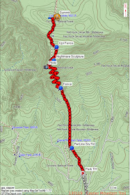
total hike distance shown on my GPS was 5.8 miles round trip, the
maximum elevation was 6840 feet and the total ascent was 2583 feet.
The GPS track is shown on the included map (below).


No comments:
Post a Comment