We
hiked to the Oak Creek/Verde River confluence on 10 January 2015.
From Cottonwood, we drove north on Hwy 89A, turned right on Cornville
Road, continued for about 2.2 miles, turned left onto Forest Road
9816 and parked just through a gate. We had an unusually large group
of hikers and I decided to gather them for a group photograph while
we were still all together at the trailhead.
We
left the FR 9816 parking area, walked across Cornville Road, passed
through a pedestrian gate on the other side and headed south on FR
9806D, a road now closed to motorized traffic. A sign clearly stated
that the road was open only to hikers, bikers and equestrians.
The
weather report had called for a 50% chance of rain and, although the
sun was flirting with the clouds and occasionally even peeking
through, we all knew that we were likely to be donning raingear
before the hike was done. Our assorted raingear ran the gamut from
at least one raincoat through a variety of ponchos and a lone plastic
garbage bag which, by the way, works very well for keeping dry.
I
hiked near the rear of the group because, with such a large group, we
needed someone to make sure we didn't lose a hiker along the way. An
additional benefit was that I could make frequent stops to view and
photograph our surroundings. I climbed a small hill just off the
trail to a good viewpoint for the following scene. The photograph
below shows Mingus Mountain at the left (west). At the right
(northwest) Black Mountain and Casner Mountain with Sycamore Gap in
between can barely be discerned through the ever more threatening
cloud cover. This again brought home the notion that we would surely
need our raingear before this hike was done.
 |
View to the west and northwest – Mingus Mountain to Casner Mountain
|
None
of us had hiked this way for several years and we were a little
unsure about the best route to take, so we just followed the road.
Unfortunately, there were too many roads to choose from and we made a
wrong turn about 1.3 miles from the start of the hike. This added
close to an extra mile to the hike. When our error became apparent,
we changed course and soon were back on the correct road. But, even
following the correct road, the one that leads most directly to the
conjunction, involves a lot of unnecessary steps for hikers. We
later found that by following the road, and including the extra mile
added by taking the wrong road, we had hiked 6.1 miles to reach the
conjunction. We resolved to correct those errors on the way back.
Eventually,
we were close enough that we could see our goal, or at least the
general area, including the Thousand Trails RV park just beyond it
and across the river.
 |
Looking beyond the conjunction to RVs lined up in the park across the river, just left of center
|
But
we still had a wide loop in the road as it turned east and made its
way along a ridge and descended into the Oak Creek Canyon. Although
we could see that the road was taking us out of our way again, it was
not yet apparent just how much additional hiking that would entail.
I measured later and found that we had gone a full extra mile by
following the road.
As
we approached the conjunction we came to another fork in the road.
We turned left so to pass by some ruins located high above Oak Creek.
The road we followed led directly to the ruins; however the ruins
themselves are located on private property and are posted to prevent
trespassing. Below is shown a view from the road.
 |
Ruins near Oak Creek/Verde River confluence
|
As
can be seen from a different angle, specifically from the road
farther up the river, there are numerous caves in the cliff just
below the visible portion of the ruins. It must once have been a
quite sizable settlement.
 Just
beyond the closed-off entrance to the ruins the road ends but a trail
continues on, following closely along the cliff rim above the creek.
This trail is quite rocky and steep in places and on this day
included a climb up a slick muddy bank to reach the cliffs above the
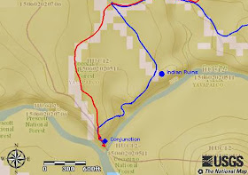
juncture. There is, however, an alternative; if we had continued
straight ahead instead of turning toward the ruins at the last road
fork we would have come out atop the cliff, just where we wanted to
be. The map insert (right) shows
these details.
As
we made our way along the cliff above Oak Creek toward the river, we
could see the creek below and the opposite side of the river between
Thousand Trails RV Park (barely visible on the left) and Alcantara
Vinyards and Winery (just out of sight on the right).
 |
Looking down Oak Creek and across the Verde River
|
There
are two distinct levels to the cliff at the juncture. The view shown
here is of the lower level as seen from the upper one. It rather
reminded me of looking down on the bow of a ship from the wheelhouse.
Oak Creek flows in from the left and the Verde River brushes the
right flank. The prominent land feature on the distant, southern
horizon directly ahead is Squaw Peak.
 |
The “bow” between Oak Creek (left) and the Verde River (right)
|
I
descended to the lower level, the “bow” so to speak, for lunch.
Looking back up the river from there I had a view along the cliff
face of the smoothly flowing river and Mingus Mountain, now partly
obscured by a rain shower, in the distance.
 |
Looking north up the Verde River
|
After
some discussion it was decided that six of the hikers would remain in
the area while the while the other twelve would hike back to the
trailhead. Those who had hiked back would then drive down Tissaw
Road, turning from Cornville Road, at Verde Santa Fe to pick up those
who had chosen to wait.
As
it turned out, the rain began almost at once and, according to
reports, much harder along the river where we had left the six hikers
than for those of us who chose to hike back to the trailhead. Chilly
and uncomfortable, they chose not to wait and had a friend pick them
up and deliver them back to Cottonwood, notifying our leader of the
change by cellphone.
Meanwhile,
those of us returning to the trailhead were soon donning our
raingear. We were touched by rain twice on the way back, never very
hard but enough for a thorough soaking without raingear.
We
did, as planned, take a shorter route back by climbing directly up
two hills and avoiding the error we made by taking the wrong road on
the way in. As a result, our return trip was only 3.7 miles instead
of the 6.1 miles for the trip in.
This
hike, based on our return track, is 7.4 miles round trip. The
highest elevation was 3588 feet and the total ascent was 626 feet.
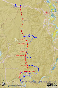
Our
track is shown on the included map (next page).
Our return track is shown in red. The hike to the conjunction is
shown in blue but is covered by red except for those areas where the
two deviate. The mm 2 notation near where we parked indicates mile
marker 2 on County Road 30 (Cornville Road).
The
turnoff onto Tissaw road is approximately one mile to the west of
where we parked. The road is clearly signed.


No comments:
Post a Comment